

Aeolian Sand Transport Potential and Its …
109
2. Central Piedmont plain that represents the low area confined between the floor
of the escarpment and the southern structural plain.
3. Southern structural plain that occupies the southern extension of Dakhla depression. It is underlain by the Nubia Sandstone Formation. The surface of this floor
rises to more than 200 m.
4. Gabal Edmonstone is an isolated hill detached from the plateau and occurs about
18 km west of Qasr. It has an elevation of about 465 m (amsl) and 300 m above
the depression plain (Brookes 1993).
2.5 Geology of Dakhla Oasis
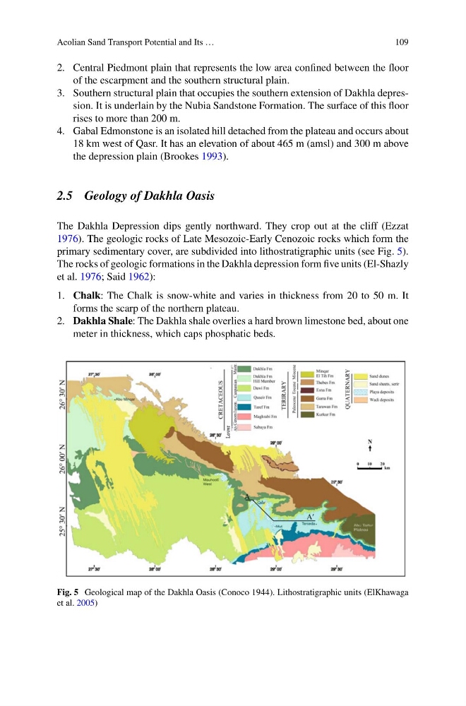
The Dakhla Depression dips gently northward. They crop out at the cliff (Ezzat
1976). The geologic rocks of Late Mesozoic-Early Cenozoic rocks which form the
primary sedimentary cover, are subdivided into lithostratigraphic units (see Fig. 5).
The rocks of geologic formations in the Dakhla depression form five units (El-Shazly
et al. 1976; Said 1962):
1. Chalk: The Chalk is snow-white and varies in thickness from 20 to 50 m. It
forms the scarp of the northern plateau.
2. Dakhla Shale: The Dakhla shale overlies a hard brown limestone bed, about one
meter in thickness, which caps phosphatic beds.
Fig. 5 Geological map of the Dakhla Oasis (Conoco 1944). Lithostratigraphic units (ElKhawaga
et al. 2005)
109
2. Central Piedmont plain that represents the low area confined between the floor
of the escarpment and the southern structural plain.
3. Southern structural plain that occupies the southern extension of Dakhla depression. It is underlain by the Nubia Sandstone Formation. The surface of this floor
rises to more than 200 m.
4. Gabal Edmonstone is an isolated hill detached from the plateau and occurs about
18 km west of Qasr. It has an elevation of about 465 m (amsl) and 300 m above
the depression plain (Brookes 1993).
2.5 Geology of Dakhla Oasis
The Dakhla Depression dips gently northward. They crop out at the cliff (Ezzat
1976). The geologic rocks of Late Mesozoic-Early Cenozoic rocks which form the
primary sedimentary cover, are subdivided into lithostratigraphic units (see Fig. 5).
The rocks of geologic formations in the Dakhla depression form five units (El-Shazly
et al. 1976; Said 1962):
1. Chalk: The Chalk is snow-white and varies in thickness from 20 to 50 m. It
forms the scarp of the northern plateau.
2. Dakhla Shale: The Dakhla shale overlies a hard brown limestone bed, about one
meter in thickness, which caps phosphatic beds.
Fig. 5 Geological map of the Dakhla Oasis (Conoco 1944). Lithostratigraphic units (ElKhawaga
et al. 2005)