

108
A. M. Sharaky
Linear dunes
Crescentic dunes
Atlantic Ocean
Star dunes
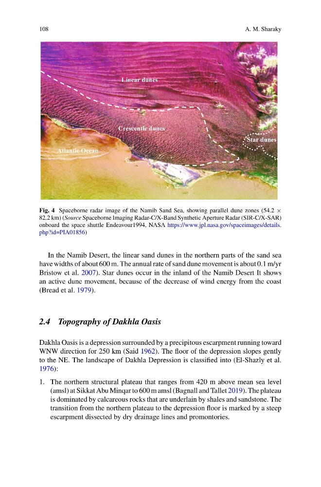
Fig. 4 Spaceborne radar image of the Namib Sand Sea, showing parallel dune zones (54.2 ×
82.2 km) (Source Spaceborne Imaging Radar-C/X-Band Synthetic Aperture Radar (SIR-C/X-SAR)
onboard the space shuttle Endeavour1994, NASA https://www.jpl.nasa.gov/spaceimages/details.
php?id=PIA01856)
In the Namib Desert, the linear sand dunes in the northern parts of the sand sea
have widths of about 600 m. The annual rate of sand dune movement is about 0.1 m/yr
Bristow et al. 2007). Star dunes occur in the inland of the Namib Desert It shows
an active dune movement, because of the decrease of wind energy from the coast
(Bread et al. 1979).
2.4 Topography of Dakhla Oasis
Dakhla Oasis is a depression surrounded by a precipitous escarpment running toward
WNW direction for 250 km (Said 1962). The floor of the depression slopes gently
to the NE. The landscape of Dakhla Depression is classified into (El-Shazly et al.
1976):
1. The northern structural plateau that ranges from 420 m above mean sea level
(amsl) at Sikkat Abu Minqar to 600 m amsl (Bagnall and Tallet 2019). The plateau
is dominated by calcareous rocks that are underlain by shales and sandstone. The
transition from the northern plateau to the depression floor is marked by a steep
escarpment dissected by dry drainage lines and promontories.
A. M. Sharaky
Linear dunes
Crescentic dunes
Atlantic Ocean
Star dunes
Fig. 4 Spaceborne radar image of the Namib Sand Sea, showing parallel dune zones (54.2 ×
82.2 km) (Source Spaceborne Imaging Radar-C/X-Band Synthetic Aperture Radar (SIR-C/X-SAR)
onboard the space shuttle Endeavour1994, NASA https://www.jpl.nasa.gov/spaceimages/details.
php?id=PIA01856)
In the Namib Desert, the linear sand dunes in the northern parts of the sand sea
have widths of about 600 m. The annual rate of sand dune movement is about 0.1 m/yr
Bristow et al. 2007). Star dunes occur in the inland of the Namib Desert It shows
an active dune movement, because of the decrease of wind energy from the coast
(Bread et al. 1979).
2.4 Topography of Dakhla Oasis
Dakhla Oasis is a depression surrounded by a precipitous escarpment running toward
WNW direction for 250 km (Said 1962). The floor of the depression slopes gently
to the NE. The landscape of Dakhla Depression is classified into (El-Shazly et al.
1976):
1. The northern structural plateau that ranges from 420 m above mean sea level
(amsl) at Sikkat Abu Minqar to 600 m amsl (Bagnall and Tallet 2019). The plateau
is dominated by calcareous rocks that are underlain by shales and sandstone. The
transition from the northern plateau to the depression floor is marked by a steep
escarpment dissected by dry drainage lines and promontories.