

5 Urbanisation and Land Use Change
79
Table 5.1 (continued)
Indicator
Description
Sources
Concentration/decentralisation
Degree to which urban
development is located
near to the CBD (e.g.
measured by the
percentage of
population and
employment within
concentric rings around
the CBD or the median
person’s/worker’s
distance in distance
units from CBD)
Galster et al.
(2001), Glaeser and
Kahn (2003), Lopez
and Hynes (2003),
Weber and Sultana
(2005), Huang et al.
(2007), Torrens
(2008)
Continuity/dispersion/fragmentation/complexity The degree to which
developable land is
built up continuously;
the degree of
irregularity of built-up
patches (measured
using certain indices
such as patch density or
more complex
statistical measures of
spatial regularity)
Galster et al.
(2001), Chin
(2002), Huang et al.
(2007), Schneider
and Woodcock
(2008), Siedentop
and Fina (2010),
Salvati and Carlucci
(2016)
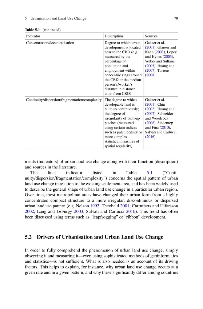
ments (indicators) of urban land use change along with their function (description)
and sources in the literature.
The
final
indicator
listed
in
Table
5.1
(“Continuity/dispersion/fragmentation/complexity”) concerns the spatial pattern of urban
land use change in relation to the existing settlement area, and has been widely used
to describe the general shape of urban land use change in a particular urban region.
Over time, most metropolitan areas have changed their urban form from a highly
concentrated compact structure to a more irregular, discontinuous or dispersed
urban land use pattern (e.g. Nelson 1992; Theobald 2001; Carruthers and Ulfarsson
2002; Lang and LeFurgy 2003; Salvati and Carlucci 2016). This trend has often
been discussed using terms such as “leapfrogging” or “ribbon” development.
5.2 Drivers of Urbanisation and Urban Land Use Change
In order to fully comprehend the phenomenon of urban land use change, simply
observing it and measuring it—even using sophisticated methods of geoinformatics
and statistics—is not sufficient. What is also needed is an account of its driving
factors. This helps to explain, for instance, why urban land use change occurs at a
given rate and in a given pattern, and why these significantly differ among countries
79
Table 5.1 (continued)
Indicator
Description
Sources
Concentration/decentralisation
Degree to which urban
development is located
near to the CBD (e.g.
measured by the
percentage of
population and
employment within
concentric rings around
the CBD or the median
person’s/worker’s
distance in distance
units from CBD)
Galster et al.
(2001), Glaeser and
Kahn (2003), Lopez
and Hynes (2003),
Weber and Sultana
(2005), Huang et al.
(2007), Torrens
(2008)
Continuity/dispersion/fragmentation/complexity The degree to which
developable land is
built up continuously;
the degree of
irregularity of built-up
patches (measured
using certain indices
such as patch density or
more complex
statistical measures of
spatial regularity)
Galster et al.
(2001), Chin
(2002), Huang et al.
(2007), Schneider
and Woodcock
(2008), Siedentop
and Fina (2010),
Salvati and Carlucci
(2016)
ments (indicators) of urban land use change along with their function (description)
and sources in the literature.
The
final
indicator
listed
in
Table
5.1
(“Continuity/dispersion/fragmentation/complexity”) concerns the spatial pattern of urban
land use change in relation to the existing settlement area, and has been widely used
to describe the general shape of urban land use change in a particular urban region.
Over time, most metropolitan areas have changed their urban form from a highly
concentrated compact structure to a more irregular, discontinuous or dispersed
urban land use pattern (e.g. Nelson 1992; Theobald 2001; Carruthers and Ulfarsson
2002; Lang and LeFurgy 2003; Salvati and Carlucci 2016). This trend has often
been discussed using terms such as “leapfrogging” or “ribbon” development.
5.2 Drivers of Urbanisation and Urban Land Use Change
In order to fully comprehend the phenomenon of urban land use change, simply
observing it and measuring it—even using sophisticated methods of geoinformatics
and statistics—is not sufficient. What is also needed is an account of its driving
factors. This helps to explain, for instance, why urban land use change occurs at a
given rate and in a given pattern, and why these significantly differ among countries