

6 Urban-Rural Interrelations—A Challenge for Sustainable Land …
107
quantitative data was available, and ignored difficult-to-measure interdependencies
such as information and financial flows, due to lack of data (Repp et al. 2012).
Stead’s model is useful for theoretically analysing the interlinkages between rural
and urban areas. However, revisions must be made to reflect current spatial current
dynamics and to grasp the even more complex interactions (Repp et al. 2012). One
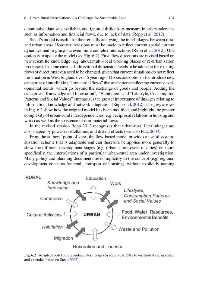
option is to update the model (see Fig. 6.2). First, flow directions are revised based on
new scientific knowledge (e.g. about multi-local working places or re-urbanisation
processes). In some cases, a bidirectional dimension needs to be added to the existing
flows or directions even need to be changed, given that current situations do not reflect
the situation in West England over 15 years ago. The second option is to introduce new
categories of interlinking “immaterial flows” that are better at reflecting current developmental trends, which go beyond the exchange of goods and people. Adding the
categories “Knowledge and Innovation”, “Habitation” and “Lifestyle, Consumption
Patterns and Social Values” emphasises the greater importance of linkages relating to
information, knowledge and network integration (Repp et al. 2012). The grey arrows
in Fig. 6.2 show how the original model has been modified, and highlight the greater
complexity of urban-rural interdependencies (e.g. reciprocal relations in housing and
work) as well as the existence of non-material flows.
In the revised version Repp 2012 recognizes that urban-rural interlinkages are
also shaped by power constellations and distant effects (see also Pütz 2004).
From the authors’ point of view, the flow-based model provides a useful systematisation scheme that is adaptable and can therefore be applied more generally to
show the different development stages (e.g. urbanisation cycle of cities) or, more
specifically, the interrelations of a particular urban-rural area under investigation.
Many policy and planning documents refer implicitly to the concept (e.g. regional
development concepts for retail, transport or housing), without explicitly naming
Fig. 6.2 Adapted model of rural-urban interlinkages by Repp et al. 2012 (own illustration, modified
and extended based on Stead 2002)
107
quantitative data was available, and ignored difficult-to-measure interdependencies
such as information and financial flows, due to lack of data (Repp et al. 2012).
Stead’s model is useful for theoretically analysing the interlinkages between rural
and urban areas. However, revisions must be made to reflect current spatial current
dynamics and to grasp the even more complex interactions (Repp et al. 2012). One
option is to update the model (see Fig. 6.2). First, flow directions are revised based on
new scientific knowledge (e.g. about multi-local working places or re-urbanisation
processes). In some cases, a bidirectional dimension needs to be added to the existing
flows or directions even need to be changed, given that current situations do not reflect
the situation in West England over 15 years ago. The second option is to introduce new
categories of interlinking “immaterial flows” that are better at reflecting current developmental trends, which go beyond the exchange of goods and people. Adding the
categories “Knowledge and Innovation”, “Habitation” and “Lifestyle, Consumption
Patterns and Social Values” emphasises the greater importance of linkages relating to
information, knowledge and network integration (Repp et al. 2012). The grey arrows
in Fig. 6.2 show how the original model has been modified, and highlight the greater
complexity of urban-rural interdependencies (e.g. reciprocal relations in housing and
work) as well as the existence of non-material flows.
In the revised version Repp 2012 recognizes that urban-rural interlinkages are
also shaped by power constellations and distant effects (see also Pütz 2004).
From the authors’ point of view, the flow-based model provides a useful systematisation scheme that is adaptable and can therefore be applied more generally to
show the different development stages (e.g. urbanisation cycle of cities) or, more
specifically, the interrelations of a particular urban-rural area under investigation.
Many policy and planning documents refer implicitly to the concept (e.g. regional
development concepts for retail, transport or housing), without explicitly naming
Fig. 6.2 Adapted model of rural-urban interlinkages by Repp et al. 2012 (own illustration, modified
and extended based on Stead 2002)