

94
M. D. Setiawati et al.
was defined in reference of land cover map from the Indonesian Geospatial Agency
(BIG), i.e., accessible here: https://tanahair.indonesia.go.id.
6.9 Land Surface Temperature
Land Surface Temperature (LST) is commonly used to measure the magnitude of
UHI at the surface level (Tomlinson et al. 2011a, b). Satellite thermal data are able to
represent the spatial gradient of radiometric surface temperature (Coll et al. 2010).
The satellite platform of LANDSAT 8 with 30 m resample of spatial resolution
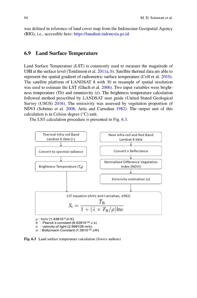
was used to estimate the LST (Gluch et al. 2006). Two input variables were brightness temperature (Tb) and emmisivity (ε). The brightness temperature calculation
followed method prescribed by LANDSAT user guide (United Stated Geological
Survey (USGS) 2016). The emissivity was assessed by vegetation proportion of
NDVI (Sobrino et al. 2008; Artis and Carnahan 1982). The output unit of this
calculation is in Celsius degree (°C) unit.
The LST calculation procedure is presented in Fig. 6.3.
Fig. 6.3 Land surface temperature calculation (Source authors)
M. D. Setiawati et al.
was defined in reference of land cover map from the Indonesian Geospatial Agency
(BIG), i.e., accessible here: https://tanahair.indonesia.go.id.
6.9 Land Surface Temperature
Land Surface Temperature (LST) is commonly used to measure the magnitude of
UHI at the surface level (Tomlinson et al. 2011a, b). Satellite thermal data are able to
represent the spatial gradient of radiometric surface temperature (Coll et al. 2010).
The satellite platform of LANDSAT 8 with 30 m resample of spatial resolution
was used to estimate the LST (Gluch et al. 2006). Two input variables were brightness temperature (Tb) and emmisivity (ε). The brightness temperature calculation
followed method prescribed by LANDSAT user guide (United Stated Geological
Survey (USGS) 2016). The emissivity was assessed by vegetation proportion of
NDVI (Sobrino et al. 2008; Artis and Carnahan 1982). The output unit of this
calculation is in Celsius degree (°C) unit.
The LST calculation procedure is presented in Fig. 6.3.
Fig. 6.3 Land surface temperature calculation (Source authors)