

5 An Overview of the Integrated Flood Analysis System (IFAS) …
75
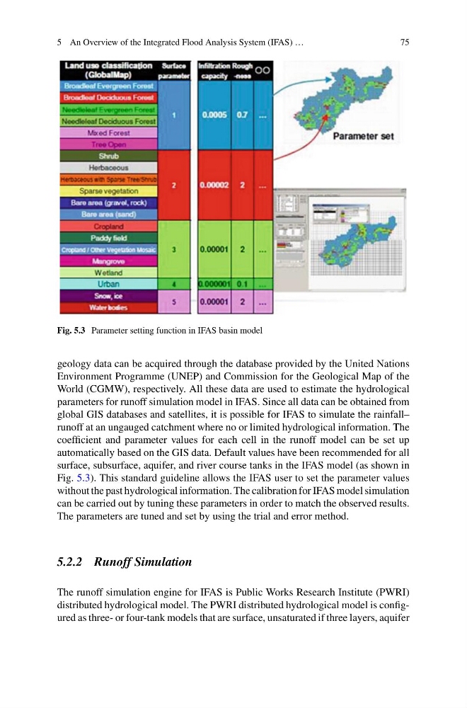
Fig. 5.3 Parameter setting function in IFAS basin model
geology data can be acquired through the database provided by the United Nations
Environment Programme (UNEP) and Commission for the Geological Map of the
World (CGMW), respectively. All these data are used to estimate the hydrological
parameters for runoff simulation model in IFAS. Since all data can be obtained from
global GIS databases and satellites, it is possible for IFAS to simulate the rainfall–
runoff at an ungauged catchment where no or limited hydrological information. The
coefficient and parameter values for each cell in the runoff model can be set up
automatically based on the GIS data. Default values have been recommended for all
surface, subsurface, aquifer, and river course tanks in the IFAS model (as shown in
Fig. 5.3). This standard guideline allows the IFAS user to set the parameter values
without the past hydrological information. The calibration for IFAS model simulation
can be carried out by tuning these parameters in order to match the observed results.
The parameters are tuned and set by using the trial and error method.
5.2.2 Runoff Simulation
The runoff simulation engine for IFAS is Public Works Research Institute (PWRI)
distributed hydrological model. The PWRI distributed hydrological model is configured as three- or four-tank models that are surface, unsaturated if three layers, aquifer
75
Fig. 5.3 Parameter setting function in IFAS basin model
geology data can be acquired through the database provided by the United Nations
Environment Programme (UNEP) and Commission for the Geological Map of the
World (CGMW), respectively. All these data are used to estimate the hydrological
parameters for runoff simulation model in IFAS. Since all data can be obtained from
global GIS databases and satellites, it is possible for IFAS to simulate the rainfall–
runoff at an ungauged catchment where no or limited hydrological information. The
coefficient and parameter values for each cell in the runoff model can be set up
automatically based on the GIS data. Default values have been recommended for all
surface, subsurface, aquifer, and river course tanks in the IFAS model (as shown in
Fig. 5.3). This standard guideline allows the IFAS user to set the parameter values
without the past hydrological information. The calibration for IFAS model simulation
can be carried out by tuning these parameters in order to match the observed results.
The parameters are tuned and set by using the trial and error method.
5.2.2 Runoff Simulation
The runoff simulation engine for IFAS is Public Works Research Institute (PWRI)
distributed hydrological model. The PWRI distributed hydrological model is configured as three- or four-tank models that are surface, unsaturated if three layers, aquifer