

4 Classifying the Forest Surfaces in Metropolitan Areas …
55
Balkans can apply the method to rapidly prepare maps of indexing the forest surfaces
by their wildfire ignition probability and wildfire spreading capacity.
4.2.2 Procedure of Data Analysis
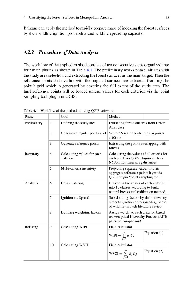
The workflow of the applied method consists of ten consecutive steps organized into
four main phases as shown in Table 4.1. The preliminary works phase initiates with
the study area selection and extracting the forest surfaces as the main target. Then the
reference points that overlap with the targeted surfaces are extracted from regular
point’s grid which is generated by covering the full extent of the study area. The
final reference points will be loaded unique values for each criterion via the point
sampling tool plugin in QGIS.
Table 4.1 Workflow of the method utilizing QGIS software
Phase
Goal
Method
Preliminary
1
Defining the study area
Extracting forest surfaces from Urban
Atlas data
2
Generating regular points grid Vector/Research tools/Regular points
(100 m)
3
Generate reference points
Extracting the points overlapping with
forests
Inventory
4
Calculating values for each
criterion
Calculating the values of all criteria for
each point via QGIS plugins such as
NNJoin for measuring distances
5
Multi-criteria inventory
Projecting separate values into an
aggregate reference points layer via
QGIS plugin “point sampling tool”
Analysis
6
Data clustering
Clustering the values of each criterion
into 10 classes according to Jenks
natural breaks reclassification method
7
Ignition vs. Spread
Sub-dividing factors by their relevancy
either to ignition or to spreading phase
of wildfire through literature review
8
Defining weighting factors
Assign weight to each criterion based
on Analytical Hierarchy Process (AHP,
pairwise comparison)
Indexing
9
Calculating WIPI
Field calculator
WIPI =
n
i=1
α i C i
Equation (1)
10
Calculating WSCI
Field calculator
WSCI =
m
j=1
β j C j
Equation (2)
55
Balkans can apply the method to rapidly prepare maps of indexing the forest surfaces
by their wildfire ignition probability and wildfire spreading capacity.
4.2.2 Procedure of Data Analysis
The workflow of the applied method consists of ten consecutive steps organized into
four main phases as shown in Table 4.1. The preliminary works phase initiates with
the study area selection and extracting the forest surfaces as the main target. Then the
reference points that overlap with the targeted surfaces are extracted from regular
point’s grid which is generated by covering the full extent of the study area. The
final reference points will be loaded unique values for each criterion via the point
sampling tool plugin in QGIS.
Table 4.1 Workflow of the method utilizing QGIS software
Phase
Goal
Method
Preliminary
1
Defining the study area
Extracting forest surfaces from Urban
Atlas data
2
Generating regular points grid Vector/Research tools/Regular points
(100 m)
3
Generate reference points
Extracting the points overlapping with
forests
Inventory
4
Calculating values for each
criterion
Calculating the values of all criteria for
each point via QGIS plugins such as
NNJoin for measuring distances
5
Multi-criteria inventory
Projecting separate values into an
aggregate reference points layer via
QGIS plugin “point sampling tool”
Analysis
6
Data clustering
Clustering the values of each criterion
into 10 classes according to Jenks
natural breaks reclassification method
7
Ignition vs. Spread
Sub-dividing factors by their relevancy
either to ignition or to spreading phase
of wildfire through literature review
8
Defining weighting factors
Assign weight to each criterion based
on Analytical Hierarchy Process (AHP,
pairwise comparison)
Indexing
9
Calculating WIPI
Field calculator
WIPI =
n
i=1
α i C i
Equation (1)
10
Calculating WSCI
Field calculator
WSCI =
m
j=1
β j C j
Equation (2)