

7 Comparative GIS-Based Assessment …
119
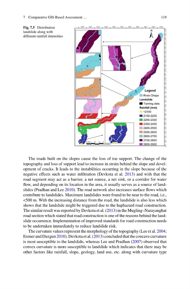
Fig. 7.5 Distribution
landslide along with
different rainfall intensities
The roads built on the slopes cause the loss of toe support. The change of the
topography and loss of support lead to increase in strain behind the slope and development of cracks. It leads to the instabilities occurring in the slope because of the
negative effects such as water infiltration (Devkota et al. 2013) and with that the
road segment may act as a barrier, a net source, a net sink, or a corridor for water
flow, and depending on its location in the area, it usually serves as a source of landslides (Pradhan and Lee 2010). The road network also increases surface flows which
contribute to landslides. Maximum landslides were found to be near to the road, i.e.,
<500 m. With the increasing distance from the road, the landslide is also less which
shows that the landslide might be triggered due to the haphazard road construction.
The similar result was reported by Devkota et al. (2013) in the Mugling–Narayanghat
road section which stated that road construction is one of the reasons behind the landslide occurrence. Implementation of improved standards for road construction needs
to be undertaken immediately to reduce landslide risk.
The curvature values represent the morphology of the topography (Lee et al. 2004;
Erener and Duzgun 2010). Devkota et al. (2013) concluded that the concave curvature
is most susceptible to the landslide, whereas Lee and Pradhan (2007) observed that
convex curvature is more susceptible to landslide which indicates that there may be
other factors like rainfall, slope, geology, land use, etc. along with curvature type
119
Fig. 7.5 Distribution
landslide along with
different rainfall intensities
The roads built on the slopes cause the loss of toe support. The change of the
topography and loss of support lead to increase in strain behind the slope and development of cracks. It leads to the instabilities occurring in the slope because of the
negative effects such as water infiltration (Devkota et al. 2013) and with that the
road segment may act as a barrier, a net source, a net sink, or a corridor for water
flow, and depending on its location in the area, it usually serves as a source of landslides (Pradhan and Lee 2010). The road network also increases surface flows which
contribute to landslides. Maximum landslides were found to be near to the road, i.e.,
<500 m. With the increasing distance from the road, the landslide is also less which
shows that the landslide might be triggered due to the haphazard road construction.
The similar result was reported by Devkota et al. (2013) in the Mugling–Narayanghat
road section which stated that road construction is one of the reasons behind the landslide occurrence. Implementation of improved standards for road construction needs
to be undertaken immediately to reduce landslide risk.
The curvature values represent the morphology of the topography (Lee et al. 2004;
Erener and Duzgun 2010). Devkota et al. (2013) concluded that the concave curvature
is most susceptible to the landslide, whereas Lee and Pradhan (2007) observed that
convex curvature is more susceptible to landslide which indicates that there may be
other factors like rainfall, slope, geology, land use, etc. along with curvature type