

7 Comparative GIS-Based Assessment …
113
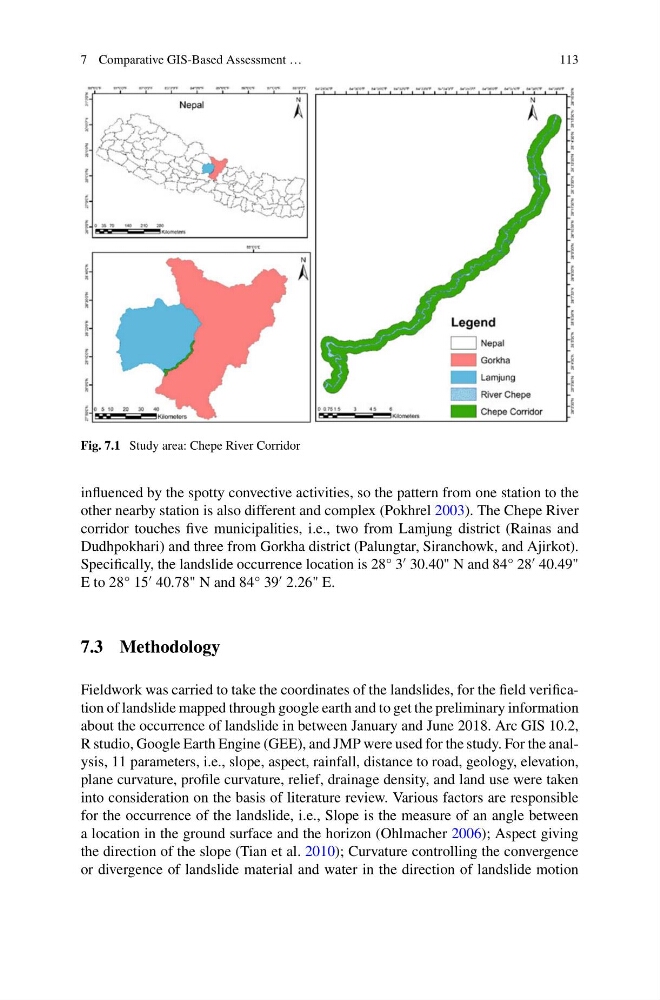
Fig. 7.1 Study area: Chepe River Corridor
influenced by the spotty convective activities, so the pattern from one station to the
other nearby station is also different and complex (Pokhrel 2003). The Chepe River
corridor touches five municipalities, i.e., two from Lamjung district (Rainas and
Dudhpokhari) and three from Gorkha district (Palungtar, Siranchowk, and Ajirkot).
Specifically, the landslide occurrence location is 28° 3
30.40" N and 84° 28
40.49"
E to 28° 15
40.78" N and 84° 39
2.26" E.
7.3 Methodology
Fieldwork was carried to take the coordinates of the landslides, for the field verification of landslide mapped through google earth and to get the preliminary information
about the occurrence of landslide in between January and June 2018. Arc GIS 10.2,
R studio, Google Earth Engine (GEE), and JMP were used for the study. For the analysis, 11 parameters, i.e., slope, aspect, rainfall, distance to road, geology, elevation,
plane curvature, profile curvature, relief, drainage density, and land use were taken
into consideration on the basis of literature review. Various factors are responsible
for the occurrence of the landslide, i.e., Slope is the measure of an angle between
a location in the ground surface and the horizon (Ohlmacher 2006); Aspect giving
the direction of the slope (Tian et al. 2010); Curvature controlling the convergence
or divergence of landslide material and water in the direction of landslide motion
113
Fig. 7.1 Study area: Chepe River Corridor
influenced by the spotty convective activities, so the pattern from one station to the
other nearby station is also different and complex (Pokhrel 2003). The Chepe River
corridor touches five municipalities, i.e., two from Lamjung district (Rainas and
Dudhpokhari) and three from Gorkha district (Palungtar, Siranchowk, and Ajirkot).
Specifically, the landslide occurrence location is 28° 3
30.40" N and 84° 28
40.49"
E to 28° 15
40.78" N and 84° 39
2.26" E.
7.3 Methodology
Fieldwork was carried to take the coordinates of the landslides, for the field verification of landslide mapped through google earth and to get the preliminary information
about the occurrence of landslide in between January and June 2018. Arc GIS 10.2,
R studio, Google Earth Engine (GEE), and JMP were used for the study. For the analysis, 11 parameters, i.e., slope, aspect, rainfall, distance to road, geology, elevation,
plane curvature, profile curvature, relief, drainage density, and land use were taken
into consideration on the basis of literature review. Various factors are responsible
for the occurrence of the landslide, i.e., Slope is the measure of an angle between
a location in the ground surface and the horizon (Ohlmacher 2006); Aspect giving
the direction of the slope (Tian et al. 2010); Curvature controlling the convergence
or divergence of landslide material and water in the direction of landslide motion