

required based on a two-tailed distribution set to cover a broader range of the
distribution due to uncertainty, where z α/2 ¼ 1.96. The required minimum sample
size is, therefore 96 households.
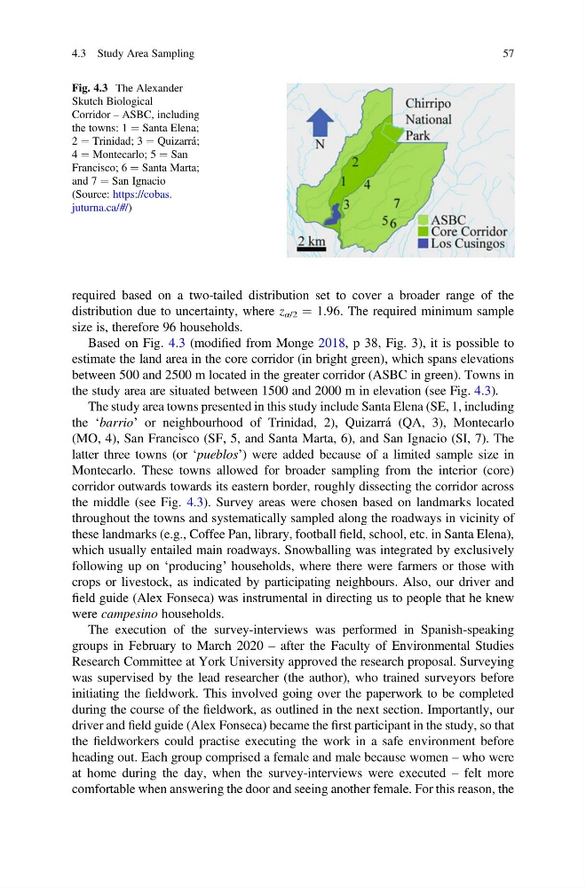
Based on Fig. 4.3 (modified from Monge 2018, p 38, Fig. 3), it is possible to
estimate the land area in the core corridor (in bright green), which spans elevations
between 500 and 2500 m located in the greater corridor (ASBC in green). Towns in
the study area are situated between 1500 and 2000 m in elevation (see Fig. 4.3).
The study area towns presented in this study include Santa Elena (SE, 1, including
the ‘barrio’ or neighbourhood of Trinidad, 2), Quizarrá (QA, 3), Montecarlo
(MO, 4), San Francisco (SF, 5, and Santa Marta, 6), and San Ignacio (SI, 7). The
latter three towns (or ‘pueblos’) were added because of a limited sample size in
Montecarlo. These towns allowed for broader sampling from the interior (core)
corridor outwards towards its eastern border, roughly dissecting the corridor across
the middle (see Fig. 4.3). Survey areas were chosen based on landmarks located
throughout the towns and systematically sampled along the roadways in vicinity of
these landmarks (e.g., Coffee Pan, library, football field, school, etc. in Santa Elena),
which usually entailed main roadways. Snowballing was integrated by exclusively
following up on ‘producing’ households, where there were farmers or those with
crops or livestock, as indicated by participating neighbours. Also, our driver and
field guide (Alex Fonseca) was instrumental in directing us to people that he knew
were campesino households.
The execution of the survey-interviews was performed in Spanish-speaking
groups in February to March 2020 – after the Faculty of Environmental Studies
Research Committee at York University approved the research proposal. Surveying
was supervised by the lead researcher (the author), who trained surveyors before
initiating the fieldwork. This involved going over the paperwork to be completed
during the course of the fieldwork, as outlined in the next section. Importantly, our
driver and field guide (Alex Fonseca) became the first participant in the study, so that
the fieldworkers could practise executing the work in a safe environment before
heading out. Each group comprised a female and male because women – who were
at home during the day, when the survey-interviews were executed – felt more
comfortable when answering the door and seeing another female. For this reason, the
Fig. 4.3 The Alexander
Skutch Biological
Corridor – ASBC, including
the towns: 1 ¼ Santa Elena;
2 ¼ Trinidad; 3 ¼ Quizarrá;
4 ¼ Montecarlo; 5 ¼ San
Francisco; 6 ¼ Santa Marta;
and 7 ¼ San Ignacio
(Source: https://cobas.
juturna.ca/#/)
4.3 Study Area Sampling
57
distribution due to uncertainty, where z α/2 ¼ 1.96. The required minimum sample
size is, therefore 96 households.
Based on Fig. 4.3 (modified from Monge 2018, p 38, Fig. 3), it is possible to
estimate the land area in the core corridor (in bright green), which spans elevations
between 500 and 2500 m located in the greater corridor (ASBC in green). Towns in
the study area are situated between 1500 and 2000 m in elevation (see Fig. 4.3).
The study area towns presented in this study include Santa Elena (SE, 1, including
the ‘barrio’ or neighbourhood of Trinidad, 2), Quizarrá (QA, 3), Montecarlo
(MO, 4), San Francisco (SF, 5, and Santa Marta, 6), and San Ignacio (SI, 7). The
latter three towns (or ‘pueblos’) were added because of a limited sample size in
Montecarlo. These towns allowed for broader sampling from the interior (core)
corridor outwards towards its eastern border, roughly dissecting the corridor across
the middle (see Fig. 4.3). Survey areas were chosen based on landmarks located
throughout the towns and systematically sampled along the roadways in vicinity of
these landmarks (e.g., Coffee Pan, library, football field, school, etc. in Santa Elena),
which usually entailed main roadways. Snowballing was integrated by exclusively
following up on ‘producing’ households, where there were farmers or those with
crops or livestock, as indicated by participating neighbours. Also, our driver and
field guide (Alex Fonseca) was instrumental in directing us to people that he knew
were campesino households.
The execution of the survey-interviews was performed in Spanish-speaking
groups in February to March 2020 – after the Faculty of Environmental Studies
Research Committee at York University approved the research proposal. Surveying
was supervised by the lead researcher (the author), who trained surveyors before
initiating the fieldwork. This involved going over the paperwork to be completed
during the course of the fieldwork, as outlined in the next section. Importantly, our
driver and field guide (Alex Fonseca) became the first participant in the study, so that
the fieldworkers could practise executing the work in a safe environment before
heading out. Each group comprised a female and male because women – who were
at home during the day, when the survey-interviews were executed – felt more
comfortable when answering the door and seeing another female. For this reason, the
Fig. 4.3 The Alexander
Skutch Biological
Corridor – ASBC, including
the towns: 1 ¼ Santa Elena;
2 ¼ Trinidad; 3 ¼ Quizarrá;
4 ¼ Montecarlo; 5 ¼ San
Francisco; 6 ¼ Santa Marta;
and 7 ¼ San Ignacio
(Source: https://cobas.
juturna.ca/#/)
4.3 Study Area Sampling
57