

One of the important things that should be known about
the Saline and Sebeka soils is the depth of the salt horizon.
The closer it is to the surface, the more harmful it is to the
growth of plants. Salty soils usually contain several types of
salts prevailing and they vary in the extent of damage they
cause to plants. The most harmful salt to plants is sodium
salt, followed by chloride salts, while the least harmful is
sulfate salts. Where the concentration of sodium salts is high
relative to other types of salt, a sodic soil may develop
(Zurqani el at. 2018, 2019).
These soils also differ in terms of textures: some of them
are sandy soils, some silt sand, and others clay loam, but all
are characterized by their weak integration and severity of
disintegration. They are spread in the western and central
coastal areas, the Benghazi plain region, and most of the
oases and southern old valleys, with a total estimated area of
about 400,000 hectares. These soils are classified under the
great group level in Libya based on the existence or absence
of a groundwater level that is close to the surface (Table 4.9
and Fig. 4.10) (Ben Mahmoud 2013).
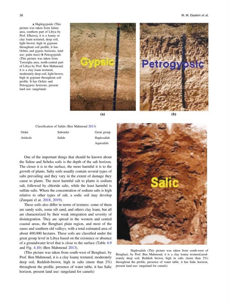
(This picture was taken from south-west of Benghazi, by
Prof. Ben Mahmoud, it is a clay loamy textured, moderately
deep soil, Reddish-brown, high in salts (more than 2%)
throughout the profile, presence of water table, it has Salic
horizon, present land use: rangeland for camels)
Fig. 4.9 a Haplogypsids (This
picture was taken from Jafara
area, southern part of Libya by
Prof. Elhawej, it is a loamy or
clay loam textured, deep soil,
light brown, high in gypsum
throughout soil profile, it has
Ochric and gypsic horizons, land
use: palm trees) b Petrogypsids
(This picture was taken from
Tawergha area, north-central part
of Libya by Prof. Ben Mahmoud,
it is a clay loam textured,
moderately deep soil, light brown,
high in gypsum throughout soil
profile. It has Ochric and
Petrogypsic horizons, present
land use: rangeland)
Table 4.9 Classification of Salids (Ben Mahmoud 2013)
Order
Suborder
Great group
Aridsols
Salids
Haplosalids
Aquisalids
Fig. 4.10 Haplosalids (This picture was taken from south-west of
Benghazi, by Prof. Ben Mahmoud, it is a clay loamy textured,moderately deep soil, Reddish brown, high in salts (more than 2%)
throughout the profile, presence of water table. it has Salic horizon,
present land use: rangeland for camels)
58
M. M. Elaalem et al.
the Saline and Sebeka soils is the depth of the salt horizon.
The closer it is to the surface, the more harmful it is to the
growth of plants. Salty soils usually contain several types of
salts prevailing and they vary in the extent of damage they
cause to plants. The most harmful salt to plants is sodium
salt, followed by chloride salts, while the least harmful is
sulfate salts. Where the concentration of sodium salts is high
relative to other types of salt, a sodic soil may develop
(Zurqani el at. 2018, 2019).
These soils also differ in terms of textures: some of them
are sandy soils, some silt sand, and others clay loam, but all
are characterized by their weak integration and severity of
disintegration. They are spread in the western and central
coastal areas, the Benghazi plain region, and most of the
oases and southern old valleys, with a total estimated area of
about 400,000 hectares. These soils are classified under the
great group level in Libya based on the existence or absence
of a groundwater level that is close to the surface (Table 4.9
and Fig. 4.10) (Ben Mahmoud 2013).
(This picture was taken from south-west of Benghazi, by
Prof. Ben Mahmoud, it is a clay loamy textured, moderately
deep soil, Reddish-brown, high in salts (more than 2%)
throughout the profile, presence of water table, it has Salic
horizon, present land use: rangeland for camels)
Fig. 4.9 a Haplogypsids (This
picture was taken from Jafara
area, southern part of Libya by
Prof. Elhawej, it is a loamy or
clay loam textured, deep soil,
light brown, high in gypsum
throughout soil profile, it has
Ochric and gypsic horizons, land
use: palm trees) b Petrogypsids
(This picture was taken from
Tawergha area, north-central part
of Libya by Prof. Ben Mahmoud,
it is a clay loam textured,
moderately deep soil, light brown,
high in gypsum throughout soil
profile. It has Ochric and
Petrogypsic horizons, present
land use: rangeland)
Table 4.9 Classification of Salids (Ben Mahmoud 2013)
Order
Suborder
Great group
Aridsols
Salids
Haplosalids
Aquisalids
Fig. 4.10 Haplosalids (This picture was taken from south-west of
Benghazi, by Prof. Ben Mahmoud, it is a clay loamy textured,moderately deep soil, Reddish brown, high in salts (more than 2%)
throughout the profile, presence of water table. it has Salic horizon,
present land use: rangeland for camels)
58
M. M. Elaalem et al.