

and pine. The planting of coniferous species was initiated in
the Edo period (1603–1868 AD), and planted coniferous
forests account for 40% of total forests in recent years.
Reflecting the complex topography of Japan, the distribution patterns of land use are also very complicated. The
majority of mountainous, hilly and volcanic areas are covered
with forests, while some of these areas are used for farmland,
such as pasture and orchard. Most agricultural lands in cities
situated in flat areas and suburban alluvial lowlands are
mainly used for paddy fields, and higher terraces are used for
upland cultivation, fruit orchards and tea fields. In the northern and the eastern parts of Hokkaido Island, flat areas are
used for farmland, forest and pasture, since they are not
suitable for rice farming due to the low temperature. The
distribution of fruit orchards and tea fields is quite different
from region to region, due to the influence of social and
economic conditions as well as natural conditions.
According to the White Paper on Land, 2018 (Ministry of
Land, Transport and Tourism 2018), 66.3% of Japan is
forest, 11.8% is agricultural land and 5.11% is residential
land (Table 2.1). Between 1975 and 2016, the proportion of
agricultural land decreased from 14.8% to 11.8%. On the
other hand, the proportion of residential land increased from
4 to 5.1% and the area of roads increased from 2.4 to 3.7%
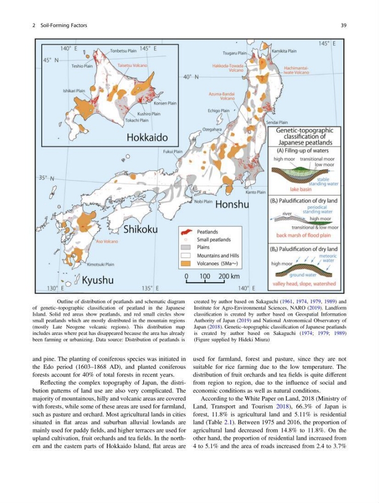
Fig. 2.26 Outline of distribution of peatlands and schematic diagram
of genetic–topographic classification of peatland in the Japanese
Island. Solid red areas show peatlands, and red small circles show
small peatlands which are mostly distributed in the mountain regions
(mostly Late Neogene volcanic regions). This distribution map
includes areas where peat has disappeared because the area has already
been farming or urbanizing. Data source: Distribution of peatlands is
created by author based on Sakaguchi (1961, 1974, 1979, 1989) and
Institute for Agro-Environmental Sciences, NARO (2019). Landform
classification is created by author based on Geospatial Information
Authority of Japan (2019) and National Astronomical Observatory of
Japan (2018). Genetic–topographic classification of Japanese peatlands
is created by author based on Sakaguchi (1974; 1979; 1989)
(Figure supplied by Hideki Miura)
2 Soil-Forming Factors
39
the Edo period (1603–1868 AD), and planted coniferous
forests account for 40% of total forests in recent years.
Reflecting the complex topography of Japan, the distribution patterns of land use are also very complicated. The
majority of mountainous, hilly and volcanic areas are covered
with forests, while some of these areas are used for farmland,
such as pasture and orchard. Most agricultural lands in cities
situated in flat areas and suburban alluvial lowlands are
mainly used for paddy fields, and higher terraces are used for
upland cultivation, fruit orchards and tea fields. In the northern and the eastern parts of Hokkaido Island, flat areas are
used for farmland, forest and pasture, since they are not
suitable for rice farming due to the low temperature. The
distribution of fruit orchards and tea fields is quite different
from region to region, due to the influence of social and
economic conditions as well as natural conditions.
According to the White Paper on Land, 2018 (Ministry of
Land, Transport and Tourism 2018), 66.3% of Japan is
forest, 11.8% is agricultural land and 5.11% is residential
land (Table 2.1). Between 1975 and 2016, the proportion of
agricultural land decreased from 14.8% to 11.8%. On the
other hand, the proportion of residential land increased from
4 to 5.1% and the area of roads increased from 2.4 to 3.7%
Fig. 2.26 Outline of distribution of peatlands and schematic diagram
of genetic–topographic classification of peatland in the Japanese
Island. Solid red areas show peatlands, and red small circles show
small peatlands which are mostly distributed in the mountain regions
(mostly Late Neogene volcanic regions). This distribution map
includes areas where peat has disappeared because the area has already
been farming or urbanizing. Data source: Distribution of peatlands is
created by author based on Sakaguchi (1961, 1974, 1979, 1989) and
Institute for Agro-Environmental Sciences, NARO (2019). Landform
classification is created by author based on Geospatial Information
Authority of Japan (2019) and National Astronomical Observatory of
Japan (2018). Genetic–topographic classification of Japanese peatlands
is created by author based on Sakaguchi (1974; 1979; 1989)
(Figure supplied by Hideki Miura)
2 Soil-Forming Factors
39