

history of the Japanese Islands can be characterized from the
viewpoint of such climate change.
(1) Denudation of mountains and volcanoes
A total of 62% of Japanese terrestrial land is composed of
mountainous and volcanic regions (Fig. 2.13). In the
mountains of the Japanese Islands, mass movement in which
slope material moves downward only under the influence of
gravity (i.e., without forces such as running water, waves,
wind, glaciers, etc.) plays an important role in changing the
slope topography. This mass movement includes the following phenomena: creep (slope material slowly moves
downward), rockfalls (one or a number of rock fragments
instantaneously fall down the slope separately from a cliff or
steep slope), landslip (material suddenly undergoes brittle
fracture, is peeled off from the slope and rapidly falls down
the slope in a disturbed state), landslide (the top lump slips
from a continuous slip surface inside the slope) and debris
flow (one or a number of rock fragments instantaneously fall
down the slope, falling apart from a cliff or steep slope).
When rain falls on a slope, the soil particles are first
transported by sheet surface flow caused by raindrops. As the
velocity and the depth of the surface flow of the depression
increase, a rill is formed by the grooved erosion, which
eventually turns into a gully. On mountain slopes in Japan,
valleys and gullies are densely distributed, so mass movements in the valley heads and side walls are the most important factors in erosion and sediment production in
mountainous areas. The slopes of large undulating mountains
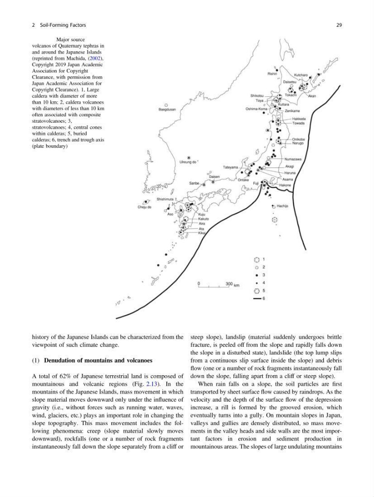
Fig. 2.16 Major source
volcanos of Quaternary tephras in
and around the Japanese Islands
(reprinted from Machida, (2002),
Copyright 2019 Japan Academic
Association for Copyright
Clearance, with permission from
Japan Academic Association for
Copyright Clearance). 1, Large
caldera with diameter of more
than 10 km; 2, caldera volcanoes
with diameters of less than 10 km
often associated with composite
stratovolcanoes; 3,
stratovolcanoes; 4, central cones
within calderas; 5, buried
calderas; 6, trench and trough axis
(plate boundary)
2 Soil-Forming Factors
29
viewpoint of such climate change.
(1) Denudation of mountains and volcanoes
A total of 62% of Japanese terrestrial land is composed of
mountainous and volcanic regions (Fig. 2.13). In the
mountains of the Japanese Islands, mass movement in which
slope material moves downward only under the influence of
gravity (i.e., without forces such as running water, waves,
wind, glaciers, etc.) plays an important role in changing the
slope topography. This mass movement includes the following phenomena: creep (slope material slowly moves
downward), rockfalls (one or a number of rock fragments
instantaneously fall down the slope separately from a cliff or
steep slope), landslip (material suddenly undergoes brittle
fracture, is peeled off from the slope and rapidly falls down
the slope in a disturbed state), landslide (the top lump slips
from a continuous slip surface inside the slope) and debris
flow (one or a number of rock fragments instantaneously fall
down the slope, falling apart from a cliff or steep slope).
When rain falls on a slope, the soil particles are first
transported by sheet surface flow caused by raindrops. As the
velocity and the depth of the surface flow of the depression
increase, a rill is formed by the grooved erosion, which
eventually turns into a gully. On mountain slopes in Japan,
valleys and gullies are densely distributed, so mass movements in the valley heads and side walls are the most important factors in erosion and sediment production in
mountainous areas. The slopes of large undulating mountains
Fig. 2.16 Major source
volcanos of Quaternary tephras in
and around the Japanese Islands
(reprinted from Machida, (2002),
Copyright 2019 Japan Academic
Association for Copyright
Clearance, with permission from
Japan Academic Association for
Copyright Clearance). 1, Large
caldera with diameter of more
than 10 km; 2, caldera volcanoes
with diameters of less than 10 km
often associated with composite
stratovolcanoes; 3,
stratovolcanoes; 4, central cones
within calderas; 5, buried
calderas; 6, trench and trough axis
(plate boundary)
2 Soil-Forming Factors
29