

the top of the land-side slope of the trench to the volcanic
front) and the “volcanic inner arc” (“back-arc” or “inner
zone”: from the volcanic front to the edge down to the edge of
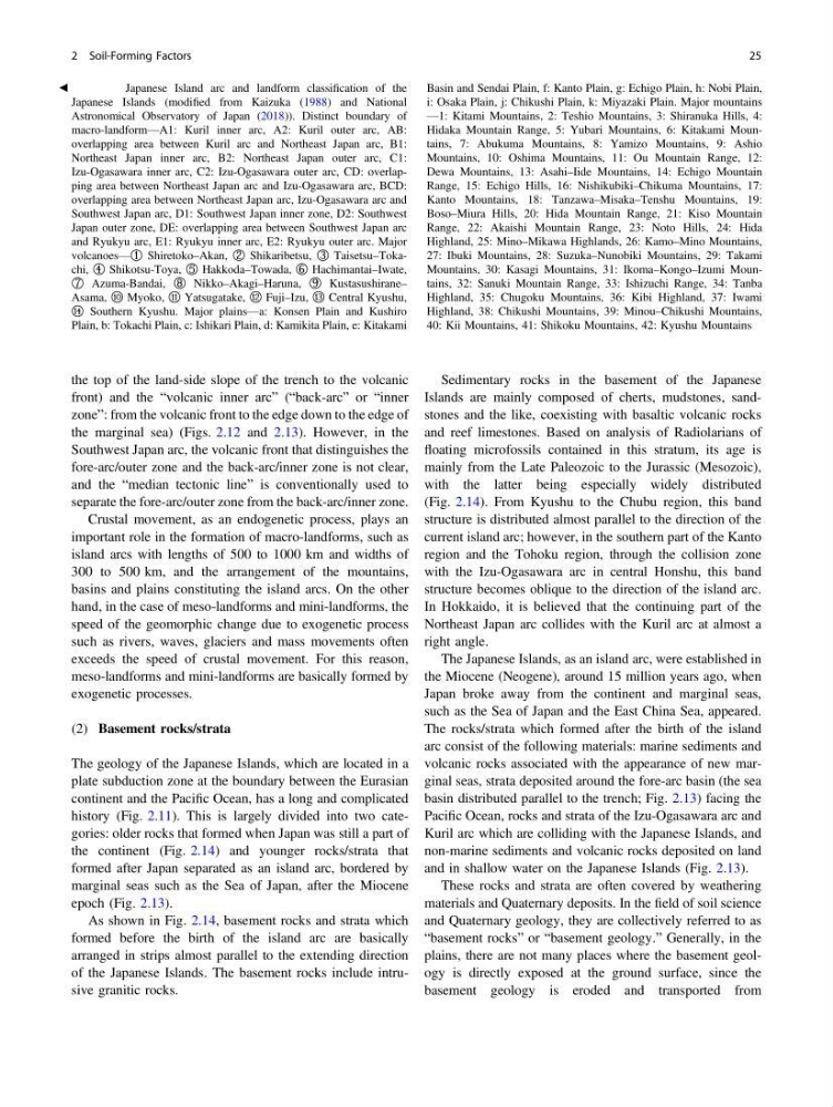
the marginal sea) (Figs. 2.12 and 2.13). However, in the
Southwest Japan arc, the volcanic front that distinguishes the
fore-arc/outer zone and the back-arc/inner zone is not clear,
and the “median tectonic line” is conventionally used to
separate the fore-arc/outer zone from the back-arc/inner zone.
Crustal movement, as an endogenetic process, plays an
important role in the formation of macro-landforms, such as
island arcs with lengths of 500 to 1000 km and widths of
300 to 500 km, and the arrangement of the mountains,
basins and plains constituting the island arcs. On the other
hand, in the case of meso-landforms and mini-landforms, the
speed of the geomorphic change due to exogenetic process
such as rivers, waves, glaciers and mass movements often
exceeds the speed of crustal movement. For this reason,
meso-landforms and mini-landforms are basically formed by
exogenetic processes.
(2) Basement rocks/strata
The geology of the Japanese Islands, which are located in a
plate subduction zone at the boundary between the Eurasian
continent and the Pacific Ocean, has a long and complicated
history (Fig. 2.11). This is largely divided into two categories: older rocks that formed when Japan was still a part of
the continent (Fig. 2.14) and younger rocks/strata that
formed after Japan separated as an island arc, bordered by
marginal seas such as the Sea of Japan, after the Miocene
epoch (Fig. 2.13).
As shown in Fig. 2.14, basement rocks and strata which
formed before the birth of the island arc are basically
arranged in strips almost parallel to the extending direction
of the Japanese Islands. The basement rocks include intrusive granitic rocks.
Sedimentary rocks in the basement of the Japanese
Islands are mainly composed of cherts, mudstones, sandstones and the like, coexisting with basaltic volcanic rocks
and reef limestones. Based on analysis of Radiolarians of
floating microfossils contained in this stratum, its age is
mainly from the Late Paleozoic to the Jurassic (Mesozoic),
with the latter being especially widely distributed
(Fig. 2.14). From Kyushu to the Chubu region, this band
structure is distributed almost parallel to the direction of the
current island arc; however, in the southern part of the Kanto
region and the Tohoku region, through the collision zone
with the Izu-Ogasawara arc in central Honshu, this band
structure becomes oblique to the direction of the island arc.
In Hokkaido, it is believed that the continuing part of the
Northeast Japan arc collides with the Kuril arc at almost a
right angle.
The Japanese Islands, as an island arc, were established in
the Miocene (Neogene), around 15 million years ago, when
Japan broke away from the continent and marginal seas,
such as the Sea of Japan and the East China Sea, appeared.
The rocks/strata which formed after the birth of the island
arc consist of the following materials: marine sediments and
volcanic rocks associated with the appearance of new marginal seas, strata deposited around the fore-arc basin (the sea
basin distributed parallel to the trench; Fig. 2.13) facing the
Pacific Ocean, rocks and strata of the Izu-Ogasawara arc and
Kuril arc which are colliding with the Japanese Islands, and
non-marine sediments and volcanic rocks deposited on land
and in shallow water on the Japanese Islands (Fig. 2.13).
These rocks and strata are often covered by weathering
materials and Quaternary deposits. In the field of soil science
and Quaternary geology, they are collectively referred to as
“basement rocks” or “basement geology.” Generally, in the
plains, there are not many places where the basement geology is directly exposed at the ground surface, since the
basement geology is eroded and transported from
b Fig. 2.13 Japanese Island arc and landform classification of the
Japanese Islands (modified from Kaizuka (1988) and National
Astronomical Observatory of Japan (2018)). Distinct boundary of
macro-landform—A1: Kuril inner arc, A2: Kuril outer arc, AB:
overlapping area between Kuril arc and Northeast Japan arc, B1:
Northeast Japan inner arc, B2: Northeast Japan outer arc, C1:
Izu-Ogasawara inner arc, C2: Izu-Ogasawara outer arc, CD: overlapping area between Northeast Japan arc and Izu-Ogasawara arc, BCD:
overlapping area between Northeast Japan arc, Izu-Ogasawara arc and
Southwest Japan arc, D1: Southwest Japan inner zone, D2: Southwest
Japan outer zone, DE: overlapping area between Southwest Japan arc
and Ryukyu arc, E1: Ryukyu inner arc, E2: Ryukyu outer arc. Major
volcanoes—① Shiretoko–Akan, ② Shikaribetsu, ③ Taisetsu–Tokachi, ④ Shikotsu-Toya, ⑤ Hakkoda–Towada, ⑥ Hachimantai–Iwate,
⑦ Azuma-Bandai, ⑧ Nikko–Akagi–Haruna, ⑨ Kustasushirane–
Asama, ⑩ Myoko, ⑪ Yatsugatake, ⑫ Fuji–Izu, ⑬ Central Kyushu,
⑭ Southern Kyushu. Major plains—a: Konsen Plain and Kushiro
Plain, b: Tokachi Plain, c: Ishikari Plain, d: Kamikita Plain, e: Kitakami
Basin and Sendai Plain, f: Kanto Plain, g: Echigo Plain, h: Nobi Plain,
i: Osaka Plain, j: Chikushi Plain, k: Miyazaki Plain. Major mountains
—1: Kitami Mountains, 2: Teshio Mountains, 3: Shiranuka Hills, 4:
Hidaka Mountain Range, 5: Yubari Mountains, 6: Kitakami Mountains, 7: Abukuma Mountains, 8: Yamizo Mountains, 9: Ashio
Mountains, 10: Oshima Mountains, 11: Ou Mountain Range, 12:
Dewa Mountains, 13: Asahi–Iide Mountains, 14: Echigo Mountain
Range, 15: Echigo Hills, 16: Nishikubiki–Chikuma Mountains, 17:
Kanto Mountains, 18: Tanzawa–Misaka–Tenshu Mountains, 19:
Boso–Miura Hills, 20: Hida Mountain Range, 21: Kiso Mountain
Range, 22: Akaishi Mountain Range, 23: Noto Hills, 24: Hida
Highland, 25: Mino–Mikawa Highlands, 26: Kamo–Mino Mountains,
27: Ibuki Mountains, 28: Suzuka–Nunobiki Mountains, 29: Takami
Mountains, 30: Kasagi Mountains, 31: Ikoma–Kongo–Izumi Mountains, 32: Sanuki Mountain Range, 33: Ishizuchi Range, 34: Tanba
Highland, 35: Chugoku Mountains, 36: Kibi Highland, 37: Iwami
Highland, 38: Chikushi Mountains, 39: Minou–Chikushi Mountains,
40: Kii Mountains, 41: Shikoku Mountains, 42: Kyushu Mountains
2 Soil-Forming Factors
25
front) and the “volcanic inner arc” (“back-arc” or “inner
zone”: from the volcanic front to the edge down to the edge of
the marginal sea) (Figs. 2.12 and 2.13). However, in the
Southwest Japan arc, the volcanic front that distinguishes the
fore-arc/outer zone and the back-arc/inner zone is not clear,
and the “median tectonic line” is conventionally used to
separate the fore-arc/outer zone from the back-arc/inner zone.
Crustal movement, as an endogenetic process, plays an
important role in the formation of macro-landforms, such as
island arcs with lengths of 500 to 1000 km and widths of
300 to 500 km, and the arrangement of the mountains,
basins and plains constituting the island arcs. On the other
hand, in the case of meso-landforms and mini-landforms, the
speed of the geomorphic change due to exogenetic process
such as rivers, waves, glaciers and mass movements often
exceeds the speed of crustal movement. For this reason,
meso-landforms and mini-landforms are basically formed by
exogenetic processes.
(2) Basement rocks/strata
The geology of the Japanese Islands, which are located in a
plate subduction zone at the boundary between the Eurasian
continent and the Pacific Ocean, has a long and complicated
history (Fig. 2.11). This is largely divided into two categories: older rocks that formed when Japan was still a part of
the continent (Fig. 2.14) and younger rocks/strata that
formed after Japan separated as an island arc, bordered by
marginal seas such as the Sea of Japan, after the Miocene
epoch (Fig. 2.13).
As shown in Fig. 2.14, basement rocks and strata which
formed before the birth of the island arc are basically
arranged in strips almost parallel to the extending direction
of the Japanese Islands. The basement rocks include intrusive granitic rocks.
Sedimentary rocks in the basement of the Japanese
Islands are mainly composed of cherts, mudstones, sandstones and the like, coexisting with basaltic volcanic rocks
and reef limestones. Based on analysis of Radiolarians of
floating microfossils contained in this stratum, its age is
mainly from the Late Paleozoic to the Jurassic (Mesozoic),
with the latter being especially widely distributed
(Fig. 2.14). From Kyushu to the Chubu region, this band
structure is distributed almost parallel to the direction of the
current island arc; however, in the southern part of the Kanto
region and the Tohoku region, through the collision zone
with the Izu-Ogasawara arc in central Honshu, this band
structure becomes oblique to the direction of the island arc.
In Hokkaido, it is believed that the continuing part of the
Northeast Japan arc collides with the Kuril arc at almost a
right angle.
The Japanese Islands, as an island arc, were established in
the Miocene (Neogene), around 15 million years ago, when
Japan broke away from the continent and marginal seas,
such as the Sea of Japan and the East China Sea, appeared.
The rocks/strata which formed after the birth of the island
arc consist of the following materials: marine sediments and
volcanic rocks associated with the appearance of new marginal seas, strata deposited around the fore-arc basin (the sea
basin distributed parallel to the trench; Fig. 2.13) facing the
Pacific Ocean, rocks and strata of the Izu-Ogasawara arc and
Kuril arc which are colliding with the Japanese Islands, and
non-marine sediments and volcanic rocks deposited on land
and in shallow water on the Japanese Islands (Fig. 2.13).
These rocks and strata are often covered by weathering
materials and Quaternary deposits. In the field of soil science
and Quaternary geology, they are collectively referred to as
“basement rocks” or “basement geology.” Generally, in the
plains, there are not many places where the basement geology is directly exposed at the ground surface, since the
basement geology is eroded and transported from
b Fig. 2.13 Japanese Island arc and landform classification of the
Japanese Islands (modified from Kaizuka (1988) and National
Astronomical Observatory of Japan (2018)). Distinct boundary of
macro-landform—A1: Kuril inner arc, A2: Kuril outer arc, AB:
overlapping area between Kuril arc and Northeast Japan arc, B1:
Northeast Japan inner arc, B2: Northeast Japan outer arc, C1:
Izu-Ogasawara inner arc, C2: Izu-Ogasawara outer arc, CD: overlapping area between Northeast Japan arc and Izu-Ogasawara arc, BCD:
overlapping area between Northeast Japan arc, Izu-Ogasawara arc and
Southwest Japan arc, D1: Southwest Japan inner zone, D2: Southwest
Japan outer zone, DE: overlapping area between Southwest Japan arc
and Ryukyu arc, E1: Ryukyu inner arc, E2: Ryukyu outer arc. Major
volcanoes—① Shiretoko–Akan, ② Shikaribetsu, ③ Taisetsu–Tokachi, ④ Shikotsu-Toya, ⑤ Hakkoda–Towada, ⑥ Hachimantai–Iwate,
⑦ Azuma-Bandai, ⑧ Nikko–Akagi–Haruna, ⑨ Kustasushirane–
Asama, ⑩ Myoko, ⑪ Yatsugatake, ⑫ Fuji–Izu, ⑬ Central Kyushu,
⑭ Southern Kyushu. Major plains—a: Konsen Plain and Kushiro
Plain, b: Tokachi Plain, c: Ishikari Plain, d: Kamikita Plain, e: Kitakami
Basin and Sendai Plain, f: Kanto Plain, g: Echigo Plain, h: Nobi Plain,
i: Osaka Plain, j: Chikushi Plain, k: Miyazaki Plain. Major mountains
—1: Kitami Mountains, 2: Teshio Mountains, 3: Shiranuka Hills, 4:
Hidaka Mountain Range, 5: Yubari Mountains, 6: Kitakami Mountains, 7: Abukuma Mountains, 8: Yamizo Mountains, 9: Ashio
Mountains, 10: Oshima Mountains, 11: Ou Mountain Range, 12:
Dewa Mountains, 13: Asahi–Iide Mountains, 14: Echigo Mountain
Range, 15: Echigo Hills, 16: Nishikubiki–Chikuma Mountains, 17:
Kanto Mountains, 18: Tanzawa–Misaka–Tenshu Mountains, 19:
Boso–Miura Hills, 20: Hida Mountain Range, 21: Kiso Mountain
Range, 22: Akaishi Mountain Range, 23: Noto Hills, 24: Hida
Highland, 25: Mino–Mikawa Highlands, 26: Kamo–Mino Mountains,
27: Ibuki Mountains, 28: Suzuka–Nunobiki Mountains, 29: Takami
Mountains, 30: Kasagi Mountains, 31: Ikoma–Kongo–Izumi Mountains, 32: Sanuki Mountain Range, 33: Ishizuchi Range, 34: Tanba
Highland, 35: Chugoku Mountains, 36: Kibi Highland, 37: Iwami
Highland, 38: Chikushi Mountains, 39: Minou–Chikushi Mountains,
40: Kii Mountains, 41: Shikoku Mountains, 42: Kyushu Mountains
2 Soil-Forming Factors
25