

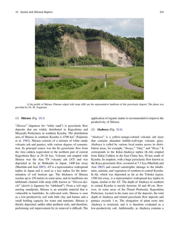
(1) Shirasu (Fig. 10.3)
“Shirasu” (Japanese for “white sand”) is pyroclastic flow
deposits that are widely distributed in Kagoshima and
Miyazaki Prefectures in southern Kyushu. The distribution
area of Shirasu in southern Kyushu is 4700 km
2 (Fujimoto
et al. 1983). Shirasu consists of a mixture of white sandy
volcanic ash and pumice, with various degrees of cementation. Its principal source was the Ito pyroclastic flow from
the Aira caldera (equivalent to the northern part of current
Kagoshima Bay) at 29–26 kya. Volcanic ash erupted with
Shirasu was the Aira TN volcanic ash (AT) and was
deposited as far as Hokkaido in Japan, 1400 km away
(Machida and Arai 2003). AT is a representative widespread
tephra in Japan and is used as a key tephra for the determination of soil horizon age. The thickness of Shirasu
reaches up to 150 meters in some areas, and its landforms are
tablelands rimmed with steep cliffs known as “Shirasu-daichi” (daichi is Japanese for “tableland”). From a soil engineering standpoint, Shirasu is an unstable material that is
vulnerable to landslides. In cultivated soils, Shirasu is seen
as a low-productivity soil with little clay and humus and a
small holding capacity for water and nutrients. Shirasu is
thickly deposited, unlike other problem soils, and therefore,
performing soil improvement by its removal is difficult. The
application of organic matter is recommended to improve the
productivity of Shirasu.
(2) Akahoya (Fig. 10.4)
“Akahoya” is a yellow-orange-colored volcanic ash layer
that contains abundant bubble-wall-type volcanic glass.
Akahoya is called by various local names across its distribution areas, for example, “Imogo,” “Onji,” and “Hoya.” It
corresponds to the Kikai-Akahoya tephra (K-Ah) erupted
from Kikai Caldera in the East China Sea, 50 km south of
Kyushu. Its eruption, with a huge pyroclastic flow known as
the Koya pyroclastic flow, occurred at 7.3 kya (Machida and
Arai 2003) and caused catastrophic damage to the inhabitants, animals, and vegetation of southern to central Kyushu.
K-Ah, which was deposited as far as the Tohoku region,
1300 km away, is a representative widespread key tephra in
Japan, similar to the AT. The depth of Akahoya in southern
to central Kyushu is mostly between 10 and 40 cm. However, in some areas of the Ōsumi Peninsula, Kagoshima
Prefecture, located in the main axis of the deposits, the total
depth of Akahoya and related pyroclastic flow deposits and
pumice exceeds 1 m. The elongation of plant roots into
Akahoya is restricted, and it is therefore evaluated as a
low-productivity soil. Additionally, as Akahoya contains a
Fig. 10.3 A big profile of Shirasu. Plateaus edged with steep cliffs are the representative landform of this pyroclastic deposit. The photo was
provided by Dr. M. Nagatomo
10 Kyushu and Okinawa Regions
333
“Shirasu” (Japanese for “white sand”) is pyroclastic flow
deposits that are widely distributed in Kagoshima and
Miyazaki Prefectures in southern Kyushu. The distribution
area of Shirasu in southern Kyushu is 4700 km
2 (Fujimoto
et al. 1983). Shirasu consists of a mixture of white sandy
volcanic ash and pumice, with various degrees of cementation. Its principal source was the Ito pyroclastic flow from
the Aira caldera (equivalent to the northern part of current
Kagoshima Bay) at 29–26 kya. Volcanic ash erupted with
Shirasu was the Aira TN volcanic ash (AT) and was
deposited as far as Hokkaido in Japan, 1400 km away
(Machida and Arai 2003). AT is a representative widespread
tephra in Japan and is used as a key tephra for the determination of soil horizon age. The thickness of Shirasu
reaches up to 150 meters in some areas, and its landforms are
tablelands rimmed with steep cliffs known as “Shirasu-daichi” (daichi is Japanese for “tableland”). From a soil engineering standpoint, Shirasu is an unstable material that is
vulnerable to landslides. In cultivated soils, Shirasu is seen
as a low-productivity soil with little clay and humus and a
small holding capacity for water and nutrients. Shirasu is
thickly deposited, unlike other problem soils, and therefore,
performing soil improvement by its removal is difficult. The
application of organic matter is recommended to improve the
productivity of Shirasu.
(2) Akahoya (Fig. 10.4)
“Akahoya” is a yellow-orange-colored volcanic ash layer
that contains abundant bubble-wall-type volcanic glass.
Akahoya is called by various local names across its distribution areas, for example, “Imogo,” “Onji,” and “Hoya.” It
corresponds to the Kikai-Akahoya tephra (K-Ah) erupted
from Kikai Caldera in the East China Sea, 50 km south of
Kyushu. Its eruption, with a huge pyroclastic flow known as
the Koya pyroclastic flow, occurred at 7.3 kya (Machida and
Arai 2003) and caused catastrophic damage to the inhabitants, animals, and vegetation of southern to central Kyushu.
K-Ah, which was deposited as far as the Tohoku region,
1300 km away, is a representative widespread key tephra in
Japan, similar to the AT. The depth of Akahoya in southern
to central Kyushu is mostly between 10 and 40 cm. However, in some areas of the Ōsumi Peninsula, Kagoshima
Prefecture, located in the main axis of the deposits, the total
depth of Akahoya and related pyroclastic flow deposits and
pumice exceeds 1 m. The elongation of plant roots into
Akahoya is restricted, and it is therefore evaluated as a
low-productivity soil. Additionally, as Akahoya contains a
Fig. 10.3 A big profile of Shirasu. Plateaus edged with steep cliffs are the representative landform of this pyroclastic deposit. The photo was
provided by Dr. M. Nagatomo
10 Kyushu and Okinawa Regions
333