

more than 1000 years. Most paddy field construction was
undertaken during two periods: the eighth to ninth century
initiation of the gridded “jori” field system and the eighteenth century extension of this system into low marshy
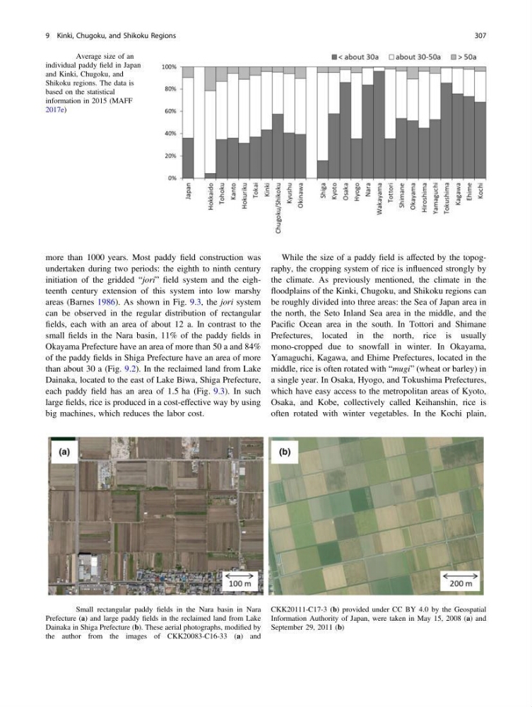
areas (Barnes 1986). As shown in Fig. 9.3, the jori system
can be observed in the regular distribution of rectangular
fields, each with an area of about 12 a. In contrast to the
small fields in the Nara basin, 11% of the paddy fields in
Okayama Prefecture have an area of more than 50 a and 84%
of the paddy fields in Shiga Prefecture have an area of more
than about 30 a (Fig. 9.2). In the reclaimed land from Lake
Dainaka, located to the east of Lake Biwa, Shiga Prefecture,
each paddy field has an area of 1.5 ha (Fig. 9.3). In such
large fields, rice is produced in a cost-effective way by using
big machines, which reduces the labor cost.
While the size of a paddy field is affected by the topography, the cropping system of rice is influenced strongly by
the climate. As previously mentioned, the climate in the
floodplains of the Kinki, Chugoku, and Shikoku regions can
be roughly divided into three areas: the Sea of Japan area in
the north, the Seto Inland Sea area in the middle, and the
Pacific Ocean area in the south. In Tottori and Shimane
Prefectures, located in the north, rice is usually
mono-cropped due to snowfall in winter. In Okayama,
Yamaguchi, Kagawa, and Ehime Prefectures, located in the
middle, rice is often rotated with “mugi” (wheat or barley) in
a single year. In Osaka, Hyogo, and Tokushima Prefectures,
which have easy access to the metropolitan areas of Kyoto,
Osaka, and Kobe, collectively called Keihanshin, rice is
often rotated with winter vegetables. In the Kochi plain,
Fig. 9.2 Average size of an
individual paddy field in Japan
and Kinki, Chugoku, and
Shikoku regions. The data is
based on the statistical
information in 2015 (MAFF
2017e)
Fig. 9.3 Small rectangular paddy fields in the Nara basin in Nara
Prefecture (a) and large paddy fields in the reclaimed land from Lake
Dainaka in Shiga Prefecture (b). These aerial photographs, modified by
the author from the images of CKK20083-C16-33 (a) and
CKK20111-C17-3 (b) provided under CC BY 4.0 by the Geospatial
Information Authority of Japan, were taken in May 15, 2008 (a) and
September 29, 2011 (b)
9 Kinki, Chugoku, and Shikoku Regions
307
undertaken during two periods: the eighth to ninth century
initiation of the gridded “jori” field system and the eighteenth century extension of this system into low marshy
areas (Barnes 1986). As shown in Fig. 9.3, the jori system
can be observed in the regular distribution of rectangular
fields, each with an area of about 12 a. In contrast to the
small fields in the Nara basin, 11% of the paddy fields in
Okayama Prefecture have an area of more than 50 a and 84%
of the paddy fields in Shiga Prefecture have an area of more
than about 30 a (Fig. 9.2). In the reclaimed land from Lake
Dainaka, located to the east of Lake Biwa, Shiga Prefecture,
each paddy field has an area of 1.5 ha (Fig. 9.3). In such
large fields, rice is produced in a cost-effective way by using
big machines, which reduces the labor cost.
While the size of a paddy field is affected by the topography, the cropping system of rice is influenced strongly by
the climate. As previously mentioned, the climate in the
floodplains of the Kinki, Chugoku, and Shikoku regions can
be roughly divided into three areas: the Sea of Japan area in
the north, the Seto Inland Sea area in the middle, and the
Pacific Ocean area in the south. In Tottori and Shimane
Prefectures, located in the north, rice is usually
mono-cropped due to snowfall in winter. In Okayama,
Yamaguchi, Kagawa, and Ehime Prefectures, located in the
middle, rice is often rotated with “mugi” (wheat or barley) in
a single year. In Osaka, Hyogo, and Tokushima Prefectures,
which have easy access to the metropolitan areas of Kyoto,
Osaka, and Kobe, collectively called Keihanshin, rice is
often rotated with winter vegetables. In the Kochi plain,
Fig. 9.2 Average size of an
individual paddy field in Japan
and Kinki, Chugoku, and
Shikoku regions. The data is
based on the statistical
information in 2015 (MAFF
2017e)
Fig. 9.3 Small rectangular paddy fields in the Nara basin in Nara
Prefecture (a) and large paddy fields in the reclaimed land from Lake
Dainaka in Shiga Prefecture (b). These aerial photographs, modified by
the author from the images of CKK20083-C16-33 (a) and
CKK20111-C17-3 (b) provided under CC BY 4.0 by the Geospatial
Information Authority of Japan, were taken in May 15, 2008 (a) and
September 29, 2011 (b)
9 Kinki, Chugoku, and Shikoku Regions
307