

Peat soils and Epi-Peaty Podzols are observed in flat areas
or on gentle slopes with low drainage from the upper cool
temperate zone to the subalpine zone. Places where Peat soil
is distributed in a coherent area are Mt. Hakuba, located to
the east of Tateyama volcano (Fig. 8.7), and Mt. Norikura in
the Hida Mountains. These peat layers sometimes contain
marker tephra that were spread nationwide by eruptions of
south Kyushu caldera volcanoes and volcanic tephra from
the Chubu region. In the Ryohaku Mountains, the AT tephra
and eruption products from Mt. Haku are intercalated in the
peat surrounding this volcano (Higashino, 2006). The K-Ah
tephra, U-Oki tephra, and AT tephra are observed in the
Ohnohara peat layer located about 50 km east-southeast of
Nagoya (Arai et al. 1988).
(2) Soils on hills and terraces
Reddish Red-Yellow soils are distributed from the foot of
the hills to the Higher Terrace of the oldest generation
(Fig. 8.8), Red-Yellow soils to Thapto-Red-Yellow Brown
Forest soils are distributed on the Middle Terrace surface,
and Brown Forest soils are distributed on the Lower Terrace
of the youngest generation. This shows the time sequence of
soil development. The Reddish Red-Yellow soils are more
weathered than the surrounding soils under the temperate
humid climate. Most of the silicate and base is leached from
the soil, which is rich in iron and aluminum, showing red
and yellow layers (Matsui and Kato 1962). The Red-Yellow
soils in the Chubu region are considered to have formed
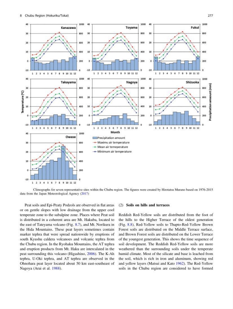
Fig. 8.3 Climographs for seven representative sites within the Chubu region. The figures were created by Hirotatsu Murano based on 1976-2015
data from the Japan Meteorological Agency (2017)
8 Chubu Region (Hokuriku/Tokai)
277
or on gentle slopes with low drainage from the upper cool
temperate zone to the subalpine zone. Places where Peat soil
is distributed in a coherent area are Mt. Hakuba, located to
the east of Tateyama volcano (Fig. 8.7), and Mt. Norikura in
the Hida Mountains. These peat layers sometimes contain
marker tephra that were spread nationwide by eruptions of
south Kyushu caldera volcanoes and volcanic tephra from
the Chubu region. In the Ryohaku Mountains, the AT tephra
and eruption products from Mt. Haku are intercalated in the
peat surrounding this volcano (Higashino, 2006). The K-Ah
tephra, U-Oki tephra, and AT tephra are observed in the
Ohnohara peat layer located about 50 km east-southeast of
Nagoya (Arai et al. 1988).
(2) Soils on hills and terraces
Reddish Red-Yellow soils are distributed from the foot of
the hills to the Higher Terrace of the oldest generation
(Fig. 8.8), Red-Yellow soils to Thapto-Red-Yellow Brown
Forest soils are distributed on the Middle Terrace surface,
and Brown Forest soils are distributed on the Lower Terrace
of the youngest generation. This shows the time sequence of
soil development. The Reddish Red-Yellow soils are more
weathered than the surrounding soils under the temperate
humid climate. Most of the silicate and base is leached from
the soil, which is rich in iron and aluminum, showing red
and yellow layers (Matsui and Kato 1962). The Red-Yellow
soils in the Chubu region are considered to have formed
Fig. 8.3 Climographs for seven representative sites within the Chubu region. The figures were created by Hirotatsu Murano based on 1976-2015
data from the Japan Meteorological Agency (2017)
8 Chubu Region (Hokuriku/Tokai)
277