

et al. 1972; Sakai 2007). Alluvial plains are often used as
paddy fields. In particular, the Sea of Japan side of Hokuriku
region is one of the major paddy rice production areas in
Japan. Upland fields and orchards are distributed in the diluvial uplands and alluvial fans. Tea fields are distributed in
Shizuoka and Mie Prefectures, while highland vegetable fields
are spread over the Central Highlands.
4. Age of geomorphic surfaces
(1) Coastal alluvial plain
The sea level after the postglacial period reached almost the
current sea level about 6 kya. Therefore, it follows that the
coastal alluvial plain was formed after this time. The sea
level in this area fell slightly between 6 and 1.5 kya, and
therefore, many of the alluvial plains are younger than
1.5 ka (Kato 1975).
(2) Terraces
Terraces in the Tokai region on the Pacific Ocean side of the
Chubu region are mainly divided into the Lower, Middle,
and Higher Terraces. The formation time of these terraces
was related to sea level change in the region. The Lower
Terrace is the youngest and was formed during a period of
falling sea level in the last glacial period about 2–50 kya
(Sakai 1963). Naruse (1974) studied the Middle and the
Higher Terraces of the Tokai region and divided the Middle
Terrace surface into three surfaces. The formation time
between the young and old surfaces was dated to 60, 80, and
12.5 ka for these three surfaces, respectively. The Higher
Terrace has been divided into two surfaces, and the formation times of the young and old surfaces were dated to 180
and 206 ka for these two surfaces, respectively. In these
terraces, redeposited parent materials that had moved from
above the slope and tephra or loess fall deposits may be
mixed in certain amounts, which cannot be ignored when
considering soil formation.
8.1.2 Soils Distribution
(1) Soils in mountainous areas
In the Chubu region, the temperature decreases with
increasing elevation, from coastal lowland to mountainous
areas; the vegetation zone also changes from warm temperate to alpine (Fig. 8.5). For this reason, climate-series
changes can be easily observed in the forest soil of this area
from Brown Forest soils to Podzols. Furthermore, weather
conditions are region-specific, for example, abundant
snowfall occurs on the Sea of Japan side, while rainfall is
more common in Kiso area, which is located further inland.
To understand the soil distribution in this region in an
orderly way, it is necessary to consider climate, parent
material, organisms, topography, and time (Sakai 2007).
The distribution of forest soils in the mountains of the Chubu
region basically changes with increasing elevation, along
with the change in climate zone (Fig. 8.6) (Kondo 1967).
For example, Haplic Brown Forest soils are distributed in
deciduous broad-leaved forests of the mountainous cold
temperature zone, where the influence of tephra deposits is
small, while Podzols are distributed in conifer forest plantations of the subalpine zone. However, from the cool temperate zone to the subalpine zone of the mountainous area,
there are many places that are affected by the tephra derived
from Quaternary volcanoes, where Non-Allophanic Andosols are often observed. In particular, there is a dominant
Non-Allophanic Andosol distribution area on the Sea of
Japan side. However, at the foot of active volcanic mountains, such as Mt. Haku, Mt. Ontake, and Mt. Norikura,
Allophanic Andosols are distributed mainly in the cold
temperature zone (Kanda et al. 2016).
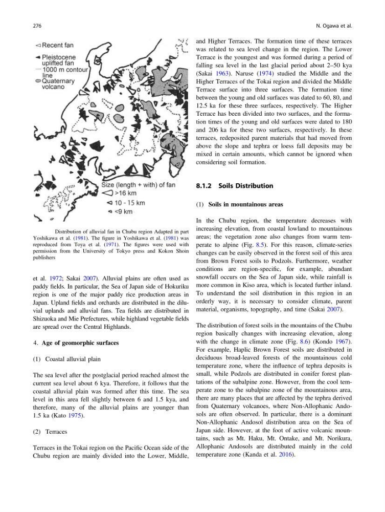
Fig. 8.2 Distribution of alluvial fan in Chubu region Adapted in part
Yoshikawa et al. (1981). The figure in Yoshikawa et al. (1981) was
reproduced from Toya et al. (1971). The figures were used with
permission from the University of Tokyo press and Kokon Shoin
publishers
276
N. Ogawa et al.
paddy fields. In particular, the Sea of Japan side of Hokuriku
region is one of the major paddy rice production areas in
Japan. Upland fields and orchards are distributed in the diluvial uplands and alluvial fans. Tea fields are distributed in
Shizuoka and Mie Prefectures, while highland vegetable fields
are spread over the Central Highlands.
4. Age of geomorphic surfaces
(1) Coastal alluvial plain
The sea level after the postglacial period reached almost the
current sea level about 6 kya. Therefore, it follows that the
coastal alluvial plain was formed after this time. The sea
level in this area fell slightly between 6 and 1.5 kya, and
therefore, many of the alluvial plains are younger than
1.5 ka (Kato 1975).
(2) Terraces
Terraces in the Tokai region on the Pacific Ocean side of the
Chubu region are mainly divided into the Lower, Middle,
and Higher Terraces. The formation time of these terraces
was related to sea level change in the region. The Lower
Terrace is the youngest and was formed during a period of
falling sea level in the last glacial period about 2–50 kya
(Sakai 1963). Naruse (1974) studied the Middle and the
Higher Terraces of the Tokai region and divided the Middle
Terrace surface into three surfaces. The formation time
between the young and old surfaces was dated to 60, 80, and
12.5 ka for these three surfaces, respectively. The Higher
Terrace has been divided into two surfaces, and the formation times of the young and old surfaces were dated to 180
and 206 ka for these two surfaces, respectively. In these
terraces, redeposited parent materials that had moved from
above the slope and tephra or loess fall deposits may be
mixed in certain amounts, which cannot be ignored when
considering soil formation.
8.1.2 Soils Distribution
(1) Soils in mountainous areas
In the Chubu region, the temperature decreases with
increasing elevation, from coastal lowland to mountainous
areas; the vegetation zone also changes from warm temperate to alpine (Fig. 8.5). For this reason, climate-series
changes can be easily observed in the forest soil of this area
from Brown Forest soils to Podzols. Furthermore, weather
conditions are region-specific, for example, abundant
snowfall occurs on the Sea of Japan side, while rainfall is
more common in Kiso area, which is located further inland.
To understand the soil distribution in this region in an
orderly way, it is necessary to consider climate, parent
material, organisms, topography, and time (Sakai 2007).
The distribution of forest soils in the mountains of the Chubu
region basically changes with increasing elevation, along
with the change in climate zone (Fig. 8.6) (Kondo 1967).
For example, Haplic Brown Forest soils are distributed in
deciduous broad-leaved forests of the mountainous cold
temperature zone, where the influence of tephra deposits is
small, while Podzols are distributed in conifer forest plantations of the subalpine zone. However, from the cool temperate zone to the subalpine zone of the mountainous area,
there are many places that are affected by the tephra derived
from Quaternary volcanoes, where Non-Allophanic Andosols are often observed. In particular, there is a dominant
Non-Allophanic Andosol distribution area on the Sea of
Japan side. However, at the foot of active volcanic mountains, such as Mt. Haku, Mt. Ontake, and Mt. Norikura,
Allophanic Andosols are distributed mainly in the cold
temperature zone (Kanda et al. 2016).
Fig. 8.2 Distribution of alluvial fan in Chubu region Adapted in part
Yoshikawa et al. (1981). The figure in Yoshikawa et al. (1981) was
reproduced from Toya et al. (1971). The figures were used with
permission from the University of Tokyo press and Kokon Shoin
publishers
276
N. Ogawa et al.