

management techniques to neutralize soil acidity in this area.
However, the base saturation level of upland soil has not
been increased. Potassium is excessively accumulated in
upland soils, and the ratio of magnesium to potassium is low.
The level of available phosphate in upland soils tends to be
higher than the prefectural recommendation. To improve
these nutritional imbalances, the appropriate use of soil
amendments based on soil diagnosis is desired. Furthermore,
the level of available nitrogen is still low in upland soils. The
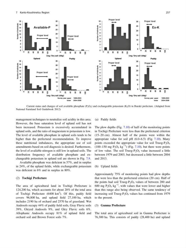
distribution frequency of available phosphate and exchangeable potassium in upland soil are shown in Fig. 7.9.
Available phosphate was deficient in 57%, and in surplus
in 24%, of the upland fields, while exchangeable potassium
was deficient in 6% and in surplus in 80%.
(2) Tochigi Prefecture
The area of agricultural land in Tochigi Prefecture is
124,200 ha, which accounts for about 20% of the total area
of Tochigi Prefecture (6408 km
2 ). Of this, paddy field
covers 96,800 ha, and upland field 27,100 ha, which
includes 2190 ha of orchard and 2570 ha of grassland. Wet
Andosols occupy 44% of paddy field soils, Gray Fluvic soils
39%, Gleyed Andosols 9%, and Gley Fluvic soils 6%.
Allophanic Andosols occupy 81% of upland field and
orchard soil and Brown Forest soils 7%.
(a) Paddy fields
The plow depths (Fig. 7.10) of half of the monitoring points
in Tochigi Prefecture were less than the prefectural criterion
(15–20 cm). Almost half of the points were within the
appropriate value for soil pH (6.0–6.5) (Fig. 7.10). Many
points exceeded the appropriate value for soil Truog-P 2 O 5
(100–150 mg P 2 O 5 kg
−1 ) (Fig. 7.10), but there were points
of low value. The soil Truog-P 2 O 5 value increased a little
between 1979 and 2003, but decreased a little between 2004
and 2013.
(b) Upland fields
Approximately 75% of monitoring points had plow depths
that were less than the prefectural criterion (20 cm). Half of
the points had soil Truog-P 2 O 5 values of between 200 and
600 mg P 2 O 5 kg
−1 , with values that were lower and higher
than this range also being observed. The same tendency of
increasing soil Truog-P 2 O 5 values has continued from 1979
to the present.
(3) Gunma Prefecture
The total area of agricultural soil in Gunma Prefecture is
76,300 ha. This consists of paddy (28,400 ha) and upland
Fig. 7.9 Current status and changes of soil available phosphate (P 2 O 5 ) and exchangeable potassium (K 2 O) in Ibaraki prefecture. (Adapted from
National Farmland Soil Guidebook 2012)
7 Kanto-Koushinetsu Region
257
However, the base saturation level of upland soil has not
been increased. Potassium is excessively accumulated in
upland soils, and the ratio of magnesium to potassium is low.
The level of available phosphate in upland soils tends to be
higher than the prefectural recommendation. To improve
these nutritional imbalances, the appropriate use of soil
amendments based on soil diagnosis is desired. Furthermore,
the level of available nitrogen is still low in upland soils. The
distribution frequency of available phosphate and exchangeable potassium in upland soil are shown in Fig. 7.9.
Available phosphate was deficient in 57%, and in surplus
in 24%, of the upland fields, while exchangeable potassium
was deficient in 6% and in surplus in 80%.
(2) Tochigi Prefecture
The area of agricultural land in Tochigi Prefecture is
124,200 ha, which accounts for about 20% of the total area
of Tochigi Prefecture (6408 km
2 ). Of this, paddy field
covers 96,800 ha, and upland field 27,100 ha, which
includes 2190 ha of orchard and 2570 ha of grassland. Wet
Andosols occupy 44% of paddy field soils, Gray Fluvic soils
39%, Gleyed Andosols 9%, and Gley Fluvic soils 6%.
Allophanic Andosols occupy 81% of upland field and
orchard soil and Brown Forest soils 7%.
(a) Paddy fields
The plow depths (Fig. 7.10) of half of the monitoring points
in Tochigi Prefecture were less than the prefectural criterion
(15–20 cm). Almost half of the points were within the
appropriate value for soil pH (6.0–6.5) (Fig. 7.10). Many
points exceeded the appropriate value for soil Truog-P 2 O 5
(100–150 mg P 2 O 5 kg
−1 ) (Fig. 7.10), but there were points
of low value. The soil Truog-P 2 O 5 value increased a little
between 1979 and 2003, but decreased a little between 2004
and 2013.
(b) Upland fields
Approximately 75% of monitoring points had plow depths
that were less than the prefectural criterion (20 cm). Half of
the points had soil Truog-P 2 O 5 values of between 200 and
600 mg P 2 O 5 kg
−1 , with values that were lower and higher
than this range also being observed. The same tendency of
increasing soil Truog-P 2 O 5 values has continued from 1979
to the present.
(3) Gunma Prefecture
The total area of agricultural soil in Gunma Prefecture is
76,300 ha. This consists of paddy (28,400 ha) and upland
Fig. 7.9 Current status and changes of soil available phosphate (P 2 O 5 ) and exchangeable potassium (K 2 O) in Ibaraki prefecture. (Adapted from
National Farmland Soil Guidebook 2012)
7 Kanto-Koushinetsu Region
257