

horizons according to eruption age. The uppermost scoria
material, the Hoei tephra, was deposited in AD 1707. The
material comprising the second horizon was deposited
around 1200 years before present (BP), corresponding to the
Medieval Warm Period. The materials comprising the third
horizon were deposited 1200–4000 years BP. The fourth
horizon is a composite of materials that are grouped into a
horizon named the “Fuji Black Horizon”, which is characterized by relatively high clay and humus contents; these
materials formed 4000–10,000 years BP, corresponding to
the Jomon transgression and the Holocene Climate Optimum.
With increasing distance from Mt. Fuji, the textures of the
soil horizons in each pedons become finer. These textures
reflect the original (primary) volcanic particles, and different
amounts of secondary particles (clay-sized minerals) that
formed to a greater or lesser extent according to the primary
particle sizes, which in turn relate to the distance from the
source volcano (Mt. Fuji). The Yamanakako soil is a Udivitrand with around 1.8 m of coarse-textured (sandy loam)
materials, including scoria (particle size > 2 mm) formed
from the Hoei tephra to the base of the third horizon. The
texture of the fourth horizon (the Fuji Black Horizon) in this
soil is light clay, being finer than those of the upper horizons
but coarser than the corresponding horizons in the other five
pedons. The soil at Ohkura is a Udivitrand, and the texture of
the first horizon (the Hoei tephra) is loamy sand to sand.
This soil has the coarsest overall texture of the six pedons
because the thickness of the Hoei tephra exceeds that in
other pedons. The Nishi-Ohtake soil is a Melanudand and
has different textures (sandy clay loam to heavy clay) than
the Ohkura soil. The Fujisawa soil is a Melanudand, and the
textures of its horizons range from light clay (first horizon;
Hoei tephra) to heavy clay (fourth horizon; Fuji Black
Horizon). This soil has a thick (2 m) humic horizon and the
highest humus content of the six pedons. The Sagamihara
soil is a Melanudand, and the textures range from silty loam
(first horizon; Hoei tephra) to heavy clay (fourth horizon;
Fuji Black Horizon). The Tachikawa soil is a Typic Melanudand. It has not share the characteristics of the other five
pedons. This soil has both of lower clay and humus content
(despite being far from Mt. Fuji) because it located on a flat
terrace with the lowest horizons formed on well-drained
alluvium, so, the soil have been received wind erosion
as effect on inhibitory action for Fuji black horizon
formation.
The contents of SiO 2 , CaO, MgO, K 2 O, and Na 2 O in soil
are decreased by eluviation, whereas the contents of Al 2 O 3 ,
Fe 2 O 3 , TiO 2 , and MnO 4 are increased because they are
residual. Therefore, the values of weathering indices such as
silica–alumina molar ratio (SiO 2 /Al 2 O 3 ) decrease in the
Yamanakako to the Tachikawa soil with increasing distance
from Mt. Fuji. The value of (Alo-Alp)/Sio ratio indicating of
types of allophane, it increase from Yamanakako (1.3) to
Fujisawa (2.0), reflecting the concomitant formation of
Si-rich to Al-rich allophane (Fig. 7.6).
The thickness of the Hoei tephra in the Yamanakako and
Ohkura soils is 20 and 60 cm, respectively. Both horizons
are lightly weathered, and hence have high Si/Al ratios and
small amounts of Si-rich allophane, halloysite, and opaline
silica, indicating a Si-rich weathering environment. Beyond
the Fujisawa area, about 27 km southeast of Ohkura, the
soils contain Al-rich allophane and gibbsite, indicating an
Al-rich weathering environment. In contrast, the Nishi-Otake
soil, located 8.2 km southeast of Ohkura, contains allophane
but not gibbsite or halloysite, suggesting that this soil is
located in a transitional zone rich in both Si and Al.
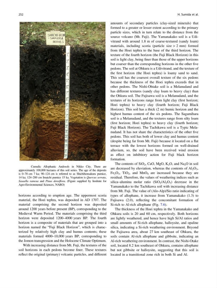
Fig. 7.4 Cumulic Allophanic Andosols in Nikko City. There are
approximately 100,000 hectares of this soil series. The age of the deposits
is 0–70 cm 7 ka; 90–124 cm is referred to as Shichihonsakura pumice,
14 ka; 124–200 cm Imaichi pumice 15 ka. Vegetation is Quercus serrata,
Sasaella ramosa and Pinus densiflora. (Figure supplied by Institute for
Agro-Environmental Sciences, NARO)
252
H. Sumida et al.
material, the Hoei tephra, was deposited in AD 1707. The
material comprising the second horizon was deposited
around 1200 years before present (BP), corresponding to the
Medieval Warm Period. The materials comprising the third
horizon were deposited 1200–4000 years BP. The fourth
horizon is a composite of materials that are grouped into a
horizon named the “Fuji Black Horizon”, which is characterized by relatively high clay and humus contents; these
materials formed 4000–10,000 years BP, corresponding to
the Jomon transgression and the Holocene Climate Optimum.
With increasing distance from Mt. Fuji, the textures of the
soil horizons in each pedons become finer. These textures
reflect the original (primary) volcanic particles, and different
amounts of secondary particles (clay-sized minerals) that
formed to a greater or lesser extent according to the primary
particle sizes, which in turn relate to the distance from the
source volcano (Mt. Fuji). The Yamanakako soil is a Udivitrand with around 1.8 m of coarse-textured (sandy loam)
materials, including scoria (particle size > 2 mm) formed
from the Hoei tephra to the base of the third horizon. The
texture of the fourth horizon (the Fuji Black Horizon) in this
soil is light clay, being finer than those of the upper horizons
but coarser than the corresponding horizons in the other five
pedons. The soil at Ohkura is a Udivitrand, and the texture of
the first horizon (the Hoei tephra) is loamy sand to sand.
This soil has the coarsest overall texture of the six pedons
because the thickness of the Hoei tephra exceeds that in
other pedons. The Nishi-Ohtake soil is a Melanudand and
has different textures (sandy clay loam to heavy clay) than
the Ohkura soil. The Fujisawa soil is a Melanudand, and the
textures of its horizons range from light clay (first horizon;
Hoei tephra) to heavy clay (fourth horizon; Fuji Black
Horizon). This soil has a thick (2 m) humic horizon and the
highest humus content of the six pedons. The Sagamihara
soil is a Melanudand, and the textures range from silty loam
(first horizon; Hoei tephra) to heavy clay (fourth horizon;
Fuji Black Horizon). The Tachikawa soil is a Typic Melanudand. It has not share the characteristics of the other five
pedons. This soil has both of lower clay and humus content
(despite being far from Mt. Fuji) because it located on a flat
terrace with the lowest horizons formed on well-drained
alluvium, so, the soil have been received wind erosion
as effect on inhibitory action for Fuji black horizon
formation.
The contents of SiO 2 , CaO, MgO, K 2 O, and Na 2 O in soil
are decreased by eluviation, whereas the contents of Al 2 O 3 ,
Fe 2 O 3 , TiO 2 , and MnO 4 are increased because they are
residual. Therefore, the values of weathering indices such as
silica–alumina molar ratio (SiO 2 /Al 2 O 3 ) decrease in the
Yamanakako to the Tachikawa soil with increasing distance
from Mt. Fuji. The value of (Alo-Alp)/Sio ratio indicating of
types of allophane, it increase from Yamanakako (1.3) to
Fujisawa (2.0), reflecting the concomitant formation of
Si-rich to Al-rich allophane (Fig. 7.6).
The thickness of the Hoei tephra in the Yamanakako and
Ohkura soils is 20 and 60 cm, respectively. Both horizons
are lightly weathered, and hence have high Si/Al ratios and
small amounts of Si-rich allophane, halloysite, and opaline
silica, indicating a Si-rich weathering environment. Beyond
the Fujisawa area, about 27 km southeast of Ohkura, the
soils contain Al-rich allophane and gibbsite, indicating an
Al-rich weathering environment. In contrast, the Nishi-Otake
soil, located 8.2 km southeast of Ohkura, contains allophane
but not gibbsite or halloysite, suggesting that this soil is
located in a transitional zone rich in both Si and Al.
Fig. 7.4 Cumulic Allophanic Andosols in Nikko City. There are
approximately 100,000 hectares of this soil series. The age of the deposits
is 0–70 cm 7 ka; 90–124 cm is referred to as Shichihonsakura pumice,
14 ka; 124–200 cm Imaichi pumice 15 ka. Vegetation is Quercus serrata,
Sasaella ramosa and Pinus densiflora. (Figure supplied by Institute for
Agro-Environmental Sciences, NARO)
252
H. Sumida et al.