

206
N. Novita et al.
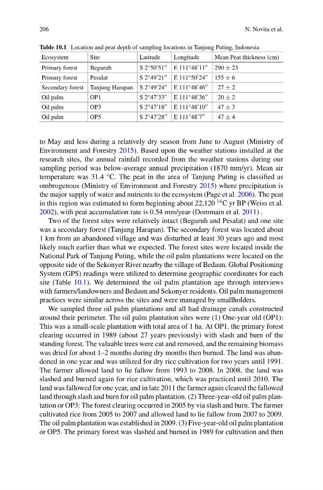
Table 10.1 Location and peat depth of sampling locations in Tanjung Puting, Indonesia
Ecosystem
Site
Latitude
Longitude
Mean Peat thickness (cm)
Primary forest
Beguruh
S 2°50 51 E 111°48 11 290 ± 23
Primary forest
Pesalat
S 2°49 21 E 111°50 24 155 ± 6
Secondary forest Tanjung Harapan S 2°49 24 E 111°48 46
27 ± 2
Oil palm
OP1
S 2°47 33 E 111°48 36
20 ± 2
Oil palm
OP3
S 2°47 18 E 111°48 10
47 ± 3
Oil palm
OP5
S 2°47 28 E 111°48 7
47 ± 4
to May and less during a relatively dry season from June to August (Ministry of
Environment and Forestry 2015). Based upon the weather stations installed at the
research sites, the annual rainfall recorded from the weather stations during our
sampling period was below-average annual precipitation (1870 mm/yr). Mean air
temperature was 31.4 °C. The peat in the area of Tanjung Puting is classified as
ombrogenous (Ministry of Environment and Forestry 2015) where precipitation is
the major supply of water and nutrients to the ecosystem (Page et al. 2006). The peat
in this region was estimated to form beginning about 22,120
14 C yr BP (Weiss et al.
2002), with peat accumulation rate is 0.54 mm/year (Dommain et al. 2011) .
Two of the forest sites were relatively intact (Beguruh and Pesalat) and one site
was a secondary forest (Tanjung Harapan). The secondary forest was located about
1 km from an abandoned village and was disturbed at least 30 years ago and most
likely much earlier than what we expected. The forest sites were located inside the
National Park of Tanjung Puting, while the oil palm plantations were located on the
opposite side of the Sekonyer River nearby the village of Bedaun. Global Positioning
System (GPS) readings were utilized to determine geographic coordinates for each
site (Table 10.1). We determined the oil palm plantation age through interviews
with farmers/landowners and Bedaun and Sekonyer residents. Oil palm management
practices were similar across the sites and were managed by smallholders.
We sampled three oil palm plantations and all had drainage canals constructed
around their perimeter. The oil palm plantation sites were (1) One-year old (OP1):
This was a small-scale plantation with total area of 1 ha. At OP1, the primary forest
clearing occurred in 1989 (about 27 years previously) with slash and burn of the
standing forest. The valuable trees were cut and removed, and the remaining biomass
was dried for about 1–2 months during dry months then burned. The land was abandoned in one year and was utilized for dry rice cultivation for two years until 1991.
The farmer allowed land to lie fallow from 1993 to 2008. In 2008, the land was
slashed and burned again for rice cultivation, which was practiced until 2010. The
land was fallowed for one year, and in late 2011 the farmer again cleared the fallowed
land through slash and burn for oil palm plantation. (2) Three-year-old oil palm plantation or OP3: The forest clearing occurred in 2005 by via slash and burn. The farmer
cultivated rice from 2005 to 2007 and allowed land to lie fallow from 2007 to 2009.
The oil palm plantation was established in 2009. (3) Five-year-old oil palm plantation
or OP5. The primary forest was slashed and burned in 1989 for cultivation and then
N. Novita et al.
Table 10.1 Location and peat depth of sampling locations in Tanjung Puting, Indonesia
Ecosystem
Site
Latitude
Longitude
Mean Peat thickness (cm)
Primary forest
Beguruh
S 2°50 51 E 111°48 11 290 ± 23
Primary forest
Pesalat
S 2°49 21 E 111°50 24 155 ± 6
Secondary forest Tanjung Harapan S 2°49 24 E 111°48 46
27 ± 2
Oil palm
OP1
S 2°47 33 E 111°48 36
20 ± 2
Oil palm
OP3
S 2°47 18 E 111°48 10
47 ± 3
Oil palm
OP5
S 2°47 28 E 111°48 7
47 ± 4
to May and less during a relatively dry season from June to August (Ministry of
Environment and Forestry 2015). Based upon the weather stations installed at the
research sites, the annual rainfall recorded from the weather stations during our
sampling period was below-average annual precipitation (1870 mm/yr). Mean air
temperature was 31.4 °C. The peat in the area of Tanjung Puting is classified as
ombrogenous (Ministry of Environment and Forestry 2015) where precipitation is
the major supply of water and nutrients to the ecosystem (Page et al. 2006). The peat
in this region was estimated to form beginning about 22,120
14 C yr BP (Weiss et al.
2002), with peat accumulation rate is 0.54 mm/year (Dommain et al. 2011) .
Two of the forest sites were relatively intact (Beguruh and Pesalat) and one site
was a secondary forest (Tanjung Harapan). The secondary forest was located about
1 km from an abandoned village and was disturbed at least 30 years ago and most
likely much earlier than what we expected. The forest sites were located inside the
National Park of Tanjung Puting, while the oil palm plantations were located on the
opposite side of the Sekonyer River nearby the village of Bedaun. Global Positioning
System (GPS) readings were utilized to determine geographic coordinates for each
site (Table 10.1). We determined the oil palm plantation age through interviews
with farmers/landowners and Bedaun and Sekonyer residents. Oil palm management
practices were similar across the sites and were managed by smallholders.
We sampled three oil palm plantations and all had drainage canals constructed
around their perimeter. The oil palm plantation sites were (1) One-year old (OP1):
This was a small-scale plantation with total area of 1 ha. At OP1, the primary forest
clearing occurred in 1989 (about 27 years previously) with slash and burn of the
standing forest. The valuable trees were cut and removed, and the remaining biomass
was dried for about 1–2 months during dry months then burned. The land was abandoned in one year and was utilized for dry rice cultivation for two years until 1991.
The farmer allowed land to lie fallow from 1993 to 2008. In 2008, the land was
slashed and burned again for rice cultivation, which was practiced until 2010. The
land was fallowed for one year, and in late 2011 the farmer again cleared the fallowed
land through slash and burn for oil palm plantation. (2) Three-year-old oil palm plantation or OP3: The forest clearing occurred in 2005 by via slash and burn. The farmer
cultivated rice from 2005 to 2007 and allowed land to lie fallow from 2007 to 2009.
The oil palm plantation was established in 2009. (3) Five-year-old oil palm plantation
or OP5. The primary forest was slashed and burned in 1989 for cultivation and then