

125
Sensemaking in Practical Design
view in the polygon map was also dependent on the s atellite-based present position,
but the direction of the camera ( which was independent from the c ourse-speed vector
of the boat) was relying on a compass direction from the phone’s internal magnetic
compass. We had little experience of the precision of these two sensors, which might
also be dependent on local conditions in the area for the test. However, to anticipate
possible problems with the compass, we made it possible to shut down this sensor
and use the course-speed vector as direction for the virtual camera in the augmented
reality layer, then assuming that the camera was fixed in a forward-looking manner
( for example, on the windscreen).
The only text-based information we considered we had time and resources to
implement was the pointer for navigational marks. The position of all buoys and
marks in the test area was collected in a list. We did not succeed in populating the
list with all the marker names in time, so the markers in the tests prototype mostly
showed “ POI” for point of interest.
RESULTS
The first iteration of the prototype was tested during a technical test in Ulsteinvik
with two people from the user group on 8 May 2017. The full user test was conducted
a month later with the six people from the user group ( Porathe & Ekskog, 2018).
technical teSt
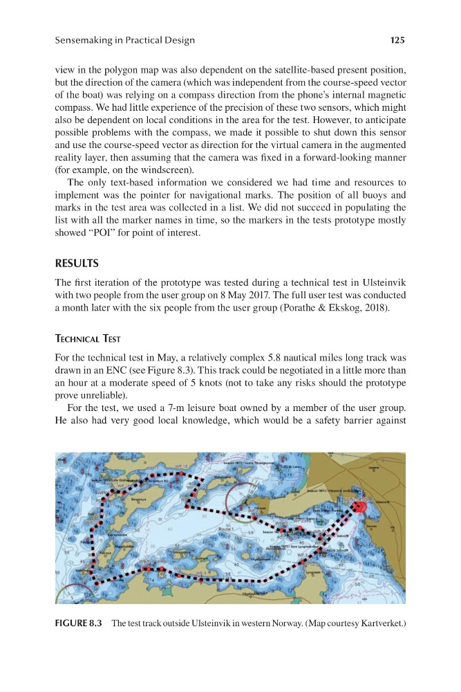
For the technical test in May, a relatively complex 5.8 nautical miles long track was
drawn in an ENC ( see Figure 8.3). This track could be negotiated in a little more than
an hour at a moderate speed of 5 knots ( not to take any risks should the prototype
prove unreliable).
For the test, we used a 7 -m leisure boat owned by a member of the user group.
He also had very good local knowledge, which would be a safety barrier against
FIGURE 8.3 The test track outside Ulsteinvik in western Norway. ( Map courtesy Kartverket.)
Sensemaking in Practical Design
view in the polygon map was also dependent on the s atellite-based present position,
but the direction of the camera ( which was independent from the c ourse-speed vector
of the boat) was relying on a compass direction from the phone’s internal magnetic
compass. We had little experience of the precision of these two sensors, which might
also be dependent on local conditions in the area for the test. However, to anticipate
possible problems with the compass, we made it possible to shut down this sensor
and use the course-speed vector as direction for the virtual camera in the augmented
reality layer, then assuming that the camera was fixed in a forward-looking manner
( for example, on the windscreen).
The only text-based information we considered we had time and resources to
implement was the pointer for navigational marks. The position of all buoys and
marks in the test area was collected in a list. We did not succeed in populating the
list with all the marker names in time, so the markers in the tests prototype mostly
showed “ POI” for point of interest.
RESULTS
The first iteration of the prototype was tested during a technical test in Ulsteinvik
with two people from the user group on 8 May 2017. The full user test was conducted
a month later with the six people from the user group ( Porathe & Ekskog, 2018).
technical teSt
For the technical test in May, a relatively complex 5.8 nautical miles long track was
drawn in an ENC ( see Figure 8.3). This track could be negotiated in a little more than
an hour at a moderate speed of 5 knots ( not to take any risks should the prototype
prove unreliable).
For the test, we used a 7 -m leisure boat owned by a member of the user group.
He also had very good local knowledge, which would be a safety barrier against
FIGURE 8.3 The test track outside Ulsteinvik in western Norway. ( Map courtesy Kartverket.)