

668
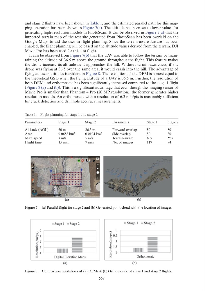
and stage 2 flights have been shown in Table 1, and the estimated parallel path for this mapping operation has been shown in Figure 7(a). The altitude has been set to lower values for
generating high-resolution models in PhotoScan. It can be observed in Figure 7(a) that the
imported terrain map of the test site generated from PhotoScan has been overlaid on the
Google Maps to aid the user in flight planning. Since the terrain-aware feature has been
enabled, the flight planning will be based on the altitude values derived from the terrain. DJI
Mavic Pro has been used for this test flight.
It can be observed from Figure 7(b) that the UAV was able to follow the terrain by maintaining the altitude of 36.5 m above the ground throughout the flight. This feature makes
the drone increase its altitude as it approaches the hill. Without terrain-awareness, if the
drone was flying at 36.5 over the same area, it would crash into the hill. The advantage of
flying at lower altitudes is evident in Figure 8. The resolution of the DEM is almost equal to
the theoretical GSD when the flying altitude of a UAV is 36.5 m. Further, the resolution of
both DEM and orthomosaic has been significantly increased compared to the stage 1 flight
(Figure 8 (a) and (b)). This is a significant advantage that even though the imaging sensor of
Mavic Pro is smaller than Phantom 4 Pro (20 MP resolution), the former generates higher
resolution models. An orthomosaic with a resolution of 6.3 mm/pix is reasonably sufficient
for crack detection and drill hole accuracy measurements.
Table 1. Flight planning for stage 1 and stage 2.
Parameters
Stage 1
Stage 2
Parameters
Stage 1
Stage 2
Altitude (AGL)
60 m
36.5 m
Forward overlap
80
80
Area
0.0658 km
2
0.0104 km
2
Side overlap
80
80
Max. speed
7 m/s
5 m/s
Terrain-aware
No
Yes
Flight time
15 min
7 min
No. of images
119
84
Figure 7. (a) Parallel flight for stage 2 and (b) Generated point cloud with the location of images.
Figure 8. Comparison resolutions of (a) DEMs & (b) Orthomosaic of stage 1 and stage 2 flights.
111 Stage 1 =Stage 2
111 Stage 1 "'Stage 2
0
j
0
I
~
>(
~ I
~0.5
- -
~2
~
1
-
-
c
c
0
.g 1.5
:z 3
-
-
IIJIIIIIIIIIIIIIII
;::>
1111 111111111111
-
-
~ 4
- -
0
2
"'
.,
~
~
Digital Elevation Maps
Orthomosaic
(a)
(b)