

236
same key variable for each data set (entirely heterotopic data). Consequently, the creation of
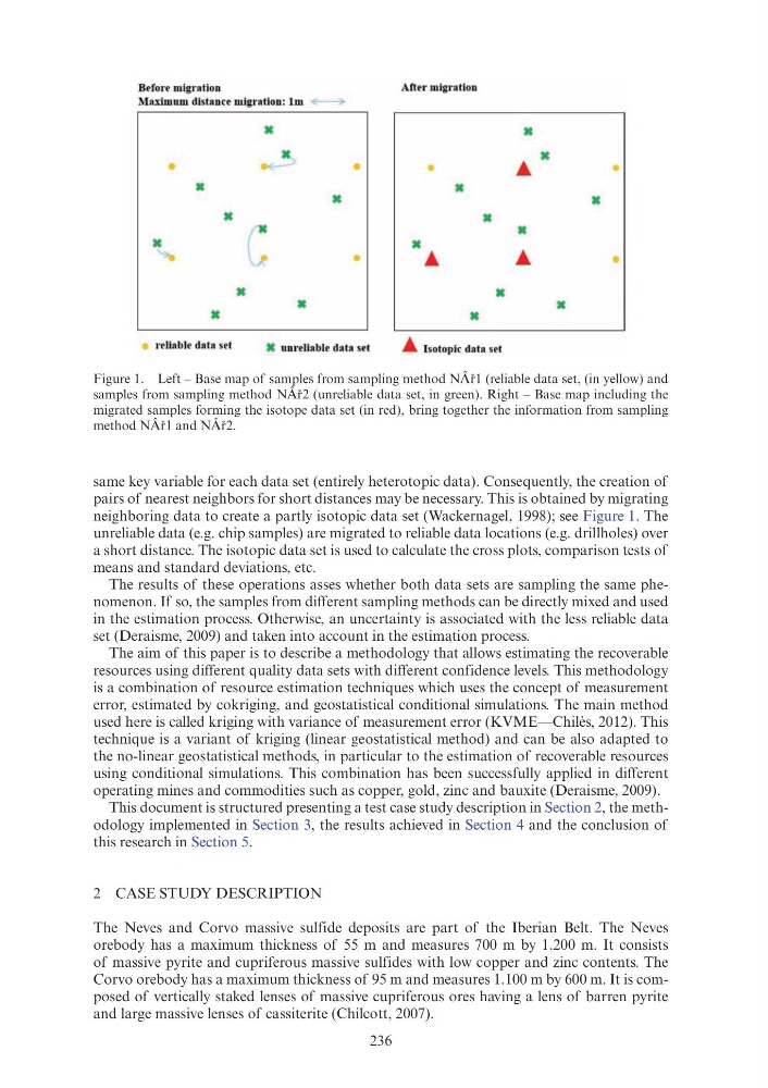
pairs of nearest neighbors for short distances may be necessary. This is obtained by migrating
neighboring data to create a partly isotopic data set (Wackernagel, 1998); see Figure 1. The
unreliable data (e.g. chip samples) are migrated to reliable data locations (e.g. drillholes) over
a short distance. The isotopic data set is used to calculate the cross plots, comparison tests of
means and standard deviations, etc.
The results of these operations asses whether both data sets are sampling the same phenomenon. If so, the samples from different sampling methods can be directly mixed and used
in the estimation process. Otherwise, an uncertainty is associated with the less reliable data
set (Deraisme, 2009) and taken into account in the estimation process.
The aim of this paper is to describe a methodology that allows estimating the recoverable
resources using different quality data sets with different confidence levels. This methodology
is a combination of resource estimation techniques which uses the concept of measurement
error, estimated by cokriging, and geostatistical conditional simulations. The main method
used here is called kriging with variance of measurement error (KVME—Chilès, 2012). This
technique is a variant of kriging (linear geostatistical method) and can be also adapted to
the no-linear geostatistical methods, in particular to the estimation of recoverable resources
using conditional simulations. This combination has been successfully applied in different
operating mines and commodities such as copper, gold, zinc and bauxite (Deraisme, 2009).
This document is structured presenting a test case study description in Section 2, the methodology implemented in Section 3, the results achieved in Section 4 and the conclusion of
this research in Section 5.
2 CASE STUDY DESCRIPTION
The Neves and Corvo massive sulfide deposits are part of the Iberian Belt. The Neves
orebody has a maximum thickness of 55 m and measures 700 m by 1.200 m. It consists
of massive pyrite and cupriferous massive sulfides with low copper and zinc contents. The
Corvo orebody has a maximum thickness of 95 m and measures 1.100 m by 600 m. It is composed of vertically staked lenses of massive cupriferous ores having a lens of barren pyrite
and large massive lenses of cassiterite (Chilcott, 2007).
Figure 1. Left – Base map of samples from sampling method NÂř1 (reliable data set, (in yellow) and
samples from sampling method NÂř2 (unreliable data set, in green). Right – Base map including the
migrated samples forming the isotope data set (in red), bring together the information from sampling
method NÂř1 and NÂř2.
Before migration
After migration
Maximum distance migration: lm
•
•
ac
ac
ac
ac
ac
•
•
•
ac
ac
ac
ac
reliable data set
ac unreliable data set
•
Isotopic data set
same key variable for each data set (entirely heterotopic data). Consequently, the creation of
pairs of nearest neighbors for short distances may be necessary. This is obtained by migrating
neighboring data to create a partly isotopic data set (Wackernagel, 1998); see Figure 1. The
unreliable data (e.g. chip samples) are migrated to reliable data locations (e.g. drillholes) over
a short distance. The isotopic data set is used to calculate the cross plots, comparison tests of
means and standard deviations, etc.
The results of these operations asses whether both data sets are sampling the same phenomenon. If so, the samples from different sampling methods can be directly mixed and used
in the estimation process. Otherwise, an uncertainty is associated with the less reliable data
set (Deraisme, 2009) and taken into account in the estimation process.
The aim of this paper is to describe a methodology that allows estimating the recoverable
resources using different quality data sets with different confidence levels. This methodology
is a combination of resource estimation techniques which uses the concept of measurement
error, estimated by cokriging, and geostatistical conditional simulations. The main method
used here is called kriging with variance of measurement error (KVME—Chilès, 2012). This
technique is a variant of kriging (linear geostatistical method) and can be also adapted to
the no-linear geostatistical methods, in particular to the estimation of recoverable resources
using conditional simulations. This combination has been successfully applied in different
operating mines and commodities such as copper, gold, zinc and bauxite (Deraisme, 2009).
This document is structured presenting a test case study description in Section 2, the methodology implemented in Section 3, the results achieved in Section 4 and the conclusion of
this research in Section 5.
2 CASE STUDY DESCRIPTION
The Neves and Corvo massive sulfide deposits are part of the Iberian Belt. The Neves
orebody has a maximum thickness of 55 m and measures 700 m by 1.200 m. It consists
of massive pyrite and cupriferous massive sulfides with low copper and zinc contents. The
Corvo orebody has a maximum thickness of 95 m and measures 1.100 m by 600 m. It is composed of vertically staked lenses of massive cupriferous ores having a lens of barren pyrite
and large massive lenses of cassiterite (Chilcott, 2007).
Figure 1. Left – Base map of samples from sampling method NÂř1 (reliable data set, (in yellow) and
samples from sampling method NÂř2 (unreliable data set, in green). Right – Base map including the
migrated samples forming the isotope data set (in red), bring together the information from sampling
method NÂř1 and NÂř2.
Before migration
After migration
Maximum distance migration: lm
•
•
ac
ac
ac
ac
ac
•
•
•
ac
ac
ac
ac
reliable data set
ac unreliable data set
•
Isotopic data set