

87
In this context, we propose a new methodology based on the use of hyperspectral spectroscopy and ASTER multispectral data for the exploration of phosphates in a specific geologic
and abruptly topographic context in Tunisia. The contribution of this study consists in mapping sedimentary phosphates in the Chaketma mine site in the center west of Tunisia using
ASTER VNIR, SWIR and TIR data. These results allow to better mark out phosphates and
minimize the impact of their exploitation on environment.
2 STUDY MINE SITE
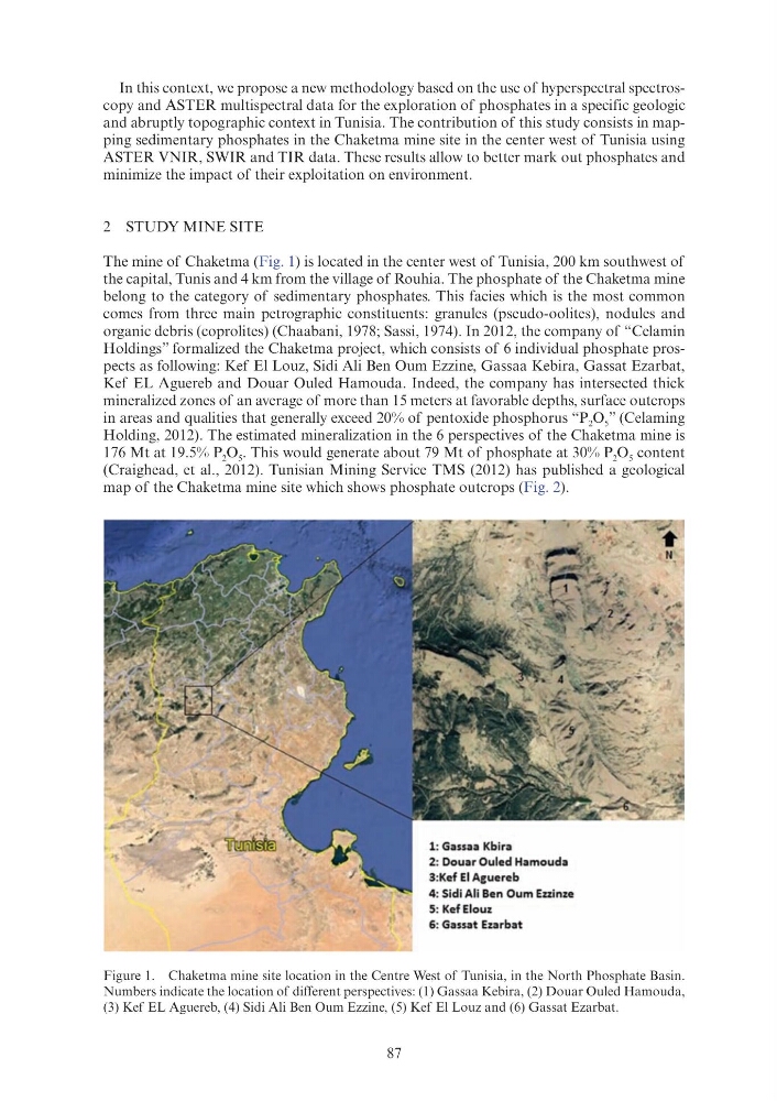
The mine of Chaketma (Fig. 1) is located in the center west of Tunisia, 200 km southwest of
the capital, Tunis and 4 km from the village of Rouhia. The phosphate of the Chaketma mine
belong to the category of sedimentary phosphates. This facies which is the most common
comes from three main petrographic constituents: granules (pseudo-oolites), nodules and
organic debris (coprolites) (Chaabani, 1978; Sassi, 1974). In 2012, the company of “Celamin
Holdings” formalized the Chaketma project, which consists of 6 individual phosphate prospects as following: Kef El Louz, Sidi Ali Ben Oum Ezzine, Gassaa Kebira, Gassat Ezarbat,
Kef EL Aguereb and Douar Ouled Hamouda. Indeed, the company has intersected thick
mineralized zones of an average of more than 15 meters at favorable depths, surface outcrops
in areas and qualities that generally exceed 20% of pentoxide phosphorus “P 2 O 5 ” (Celaming
Holding, 2012). The estimated mineralization in the 6 perspectives of the Chaketma mine is
176 Mt at 19.5% P 2 O 5 . This would generate about 79 Mt of phosphate at 30% P 2 O 5 content
(Craighead, et al., 2012). Tunisian Mining Service TMS (2012) has published a geological
map of the Chaketma mine site which shows phosphate outcrops (Fig. 2).
Figure 1. Chaketma mine site location in the Centre West of Tunisia, in the North Phosphate Basin.
Numbers indicate the location of different perspectives: (1) Gassaa Kebira, (2) Douar Ouled Hamouda,
(3) Kef EL Aguereb, (4) Sidi Ali Ben Oum Ezzine, (5) Kef El Louz and (6) Gassat Ezarbat.
1: Gassaa Kbira
2: Douar Ouled Hamouda
3:Kef El Ague reb
4: Sidi Ali Ben Oum Ezzinze
5: KefEiouz
6: Gassat Ezarbat
In this context, we propose a new methodology based on the use of hyperspectral spectroscopy and ASTER multispectral data for the exploration of phosphates in a specific geologic
and abruptly topographic context in Tunisia. The contribution of this study consists in mapping sedimentary phosphates in the Chaketma mine site in the center west of Tunisia using
ASTER VNIR, SWIR and TIR data. These results allow to better mark out phosphates and
minimize the impact of their exploitation on environment.
2 STUDY MINE SITE
The mine of Chaketma (Fig. 1) is located in the center west of Tunisia, 200 km southwest of
the capital, Tunis and 4 km from the village of Rouhia. The phosphate of the Chaketma mine
belong to the category of sedimentary phosphates. This facies which is the most common
comes from three main petrographic constituents: granules (pseudo-oolites), nodules and
organic debris (coprolites) (Chaabani, 1978; Sassi, 1974). In 2012, the company of “Celamin
Holdings” formalized the Chaketma project, which consists of 6 individual phosphate prospects as following: Kef El Louz, Sidi Ali Ben Oum Ezzine, Gassaa Kebira, Gassat Ezarbat,
Kef EL Aguereb and Douar Ouled Hamouda. Indeed, the company has intersected thick
mineralized zones of an average of more than 15 meters at favorable depths, surface outcrops
in areas and qualities that generally exceed 20% of pentoxide phosphorus “P 2 O 5 ” (Celaming
Holding, 2012). The estimated mineralization in the 6 perspectives of the Chaketma mine is
176 Mt at 19.5% P 2 O 5 . This would generate about 79 Mt of phosphate at 30% P 2 O 5 content
(Craighead, et al., 2012). Tunisian Mining Service TMS (2012) has published a geological
map of the Chaketma mine site which shows phosphate outcrops (Fig. 2).
Figure 1. Chaketma mine site location in the Centre West of Tunisia, in the North Phosphate Basin.
Numbers indicate the location of different perspectives: (1) Gassaa Kebira, (2) Douar Ouled Hamouda,
(3) Kef EL Aguereb, (4) Sidi Ali Ben Oum Ezzine, (5) Kef El Louz and (6) Gassat Ezarbat.
1: Gassaa Kbira
2: Douar Ouled Hamouda
3:Kef El Ague reb
4: Sidi Ali Ben Oum Ezzinze
5: KefEiouz
6: Gassat Ezarbat