

2.38 Barrier Islands
Barrier islands are beach deposits which are separated
from the mainland by a lagoon. They form long, thin
sand ridges which are often only a few hundred metres
to a couple of kilometres broad, and which rise up to
5–10 m above sea level.
A vertical section through the part of a barrier
island facing the sea resembles an ordinary beach
deposit (Fig. 2.40). We find a coarsening-upwards
sequence from marine clay to beach sand, often with
vegetation on top. On the lee side, facing the lagoon,
there is little wave power and clay, mud and often
oyster reefs are deposited in the lagoon. Barrier islands
are very well developed along long stretches of the
coast of North America, particularly off Texas,
Georgia and North Carolina. There are several
indications that barrier islands are due to transgressive
conditions such as those of Holocene times. This is
certainly the case along the eastern coast of the southern North Sea. When the ocean rises in relation to the
land, beach deposits can continue to grow through
gradual deposition of sand in the beach zone, but the
areas behind them sink below sea level and form a
protected lagoon with clay sedimentation. More
localised transgressions may be caused by compaction
and subsidence of sediments along a coastline where
the sediment supply is insufficient to keep pace with
the subsidence.
One prerequisite for forming barrier islands is an
adequate supply of sand, so that the island can grow
and keep pace with the transgression. This sand cannot
0 m
2-4 m
4-6 m
6-10 m
15-20 m
Aeolian sand dunes
Plant roots, foreshore bedding,
small dip
Upper shoreface, cross-bedding,
some vertical bioturbation
Middle shoreface,
a good deal of bioturbation
Transition zone, intensive bioturbation,
primary lamination often destroyed
In some cases also sand,
often residual sand,
sediments completely bioturbated
Offshore mud, shelf mud (clay and silt)
Lower shoreface,
fairly intensive bioturbation
200 m
G
ra
in
si
ze
Depth
B
e
a
c
h
b
a
r
R
u
n
n
e
l
A
e
o
li
a
n
d
u
n
e
s
B
a
c
k
s
h
o
r
e
F
o
r
e
s
h
o
r
e
U
p
p
e
r
s
h
o
r
e
f
a
c
e
M
id
d
le
s
h
o
r
e
f
a
c
e
L
o
w
e
r
s
h
o
r
e
f
a
c
e
T
r
a
n
s
it
io
n
z
o
n
e
O
f
f
s
h
o
r
e
S
h
e
lf
m
u
d
Sea level, high tide
Sea level, ebb tide
2-4m
4-6 m
6-10 m
Coarse sand
Medium sand
Fine sand
V. fine sand
Silt
Clay
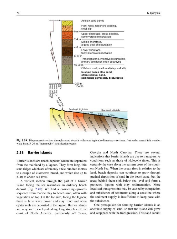
Fig. 2.39 Diagrammatic section through a sand deposit with some typical sedimentary structures. Just under normal fair weather
wave base, 5–20 m, “hummocky” stratification occurs
78
K. Bjørlykke
Barrier islands are beach deposits which are separated
from the mainland by a lagoon. They form long, thin
sand ridges which are often only a few hundred metres
to a couple of kilometres broad, and which rise up to
5–10 m above sea level.
A vertical section through the part of a barrier
island facing the sea resembles an ordinary beach
deposit (Fig. 2.40). We find a coarsening-upwards
sequence from marine clay to beach sand, often with
vegetation on top. On the lee side, facing the lagoon,
there is little wave power and clay, mud and often
oyster reefs are deposited in the lagoon. Barrier islands
are very well developed along long stretches of the
coast of North America, particularly off Texas,
Georgia and North Carolina. There are several
indications that barrier islands are due to transgressive
conditions such as those of Holocene times. This is
certainly the case along the eastern coast of the southern North Sea. When the ocean rises in relation to the
land, beach deposits can continue to grow through
gradual deposition of sand in the beach zone, but the
areas behind them sink below sea level and form a
protected lagoon with clay sedimentation. More
localised transgressions may be caused by compaction
and subsidence of sediments along a coastline where
the sediment supply is insufficient to keep pace with
the subsidence.
One prerequisite for forming barrier islands is an
adequate supply of sand, so that the island can grow
and keep pace with the transgression. This sand cannot
0 m
2-4 m
4-6 m
6-10 m
15-20 m
Aeolian sand dunes
Plant roots, foreshore bedding,
small dip
Upper shoreface, cross-bedding,
some vertical bioturbation
Middle shoreface,
a good deal of bioturbation
Transition zone, intensive bioturbation,
primary lamination often destroyed
In some cases also sand,
often residual sand,
sediments completely bioturbated
Offshore mud, shelf mud (clay and silt)
Lower shoreface,
fairly intensive bioturbation
200 m
G
ra
in
si
ze
Depth
B
e
a
c
h
b
a
r
R
u
n
n
e
l
A
e
o
li
a
n
d
u
n
e
s
B
a
c
k
s
h
o
r
e
F
o
r
e
s
h
o
r
e
U
p
p
e
r
s
h
o
r
e
f
a
c
e
M
id
d
le
s
h
o
r
e
f
a
c
e
L
o
w
e
r
s
h
o
r
e
f
a
c
e
T
r
a
n
s
it
io
n
z
o
n
e
O
f
f
s
h
o
r
e
S
h
e
lf
m
u
d
Sea level, high tide
Sea level, ebb tide
2-4m
4-6 m
6-10 m
Coarse sand
Medium sand
Fine sand
V. fine sand
Silt
Clay
Fig. 2.39 Diagrammatic section through a sand deposit with some typical sedimentary structures. Just under normal fair weather
wave base, 5–20 m, “hummocky” stratification occurs
78
K. Bjørlykke