

what lay off the Norwegian coast beneath the Quaternary sediments. Moraine material which had been
recovered from the seabed during marine geological
investigations in the 1950s contained clasts that almost
without exception were basement rocks.
The pre-Quaternary geology of the Norwegian Continental Shelf was virtually unknown prior to the early
1960s, as there had been no seismic measurements and
few other indications of what was beneath the cover of
Quaternary, partly glacial, sediments. Before any seismic or borehole data were obtained in the North Sea,
one had to extrapolate from the geology of the
surrounding land areas. The Mesozoic rocks of
northeast England and Denmark were assumed to continue beneath at least parts of the North Sea, and Carboniferous coal seams and Permian sediments were
already well known in northeastern England. There
were also a few indications that younger sedimentary
rocks were present beyond the Norwegian coast. The
moraines on Jæren contained small amounts of probably Cretaceous material, there were erratic blocks of
Jurassic age on Froan and pieces of coal from Tun in
Verran, off Trøndelag. Much farther north, the fairly
thin Jurassic and Cretaceous sequences on Andøya had
long been known. It was difficult, though, to know how
much reliance could be placed on these scattered
observations; not least, one had no idea of how thick
such Mesozoic sediments would be.
lt was difficult to know if the equivalents of the well
known source rock, the Upper Jurassic Kimmeridge
Clay extended into the Norwegian Shelf and if it was
buried deeply enough for it to be mature.
A confirmation of the presence of thick sediment
sequences on the shelf was obtained in seismic refraction
studies in the Barents Sea and the central North Sea in
the late 1950s, indicating accumulations in the order of
several kilometres. Seismic refraction studies supported
by potential field data in the Skagerrak, performed in
1963–1964, confirmed the presence of more than 3 km
of sediments also in this area. The early seismic data that
was shot in the North Sea had very poor quality and it
was not until drilling on the Norwegian shelf
commenced in 1966 that it was possible to have an
informed opinion on the potential for oil and gas.
The Norwegian continental shelf, extending from
the baseline to the limit approved by the UN Commission on the Limits of the Continental Shelf, amounts to
2.2 million km
2
. About half of this acreage has bedrock
in which petroleum may be found, and half of that has
been opened for petroleum exploration. The first
licences were awarded in 1965 and the first commercial
discovery in the Norwegian part of the North Sea (block
2/4) was made in 1969. The motivation for this drilling
was to test a possible Permian (Rotliegendes sandstone)
reservoir. Instead, however, an unexpected discovery of
hydrocarbons was made in a domal structure in Upper
Cretaceous Chalk. Continued exploration on this play
type resulted in a number of discoveries in the Ekofisk
area of the central North Sea.
Large fields in the North Sea, such as Sleipner,
Statfjord and Gullfaks, were discovered during the
first 10 years after the Ekofisk Field was proven, and
all four are still in production. Most of the other large
–5 °
0°
5°
10°
15°
20 °
55 °
60 °
6 5 °
7 0 °
7 5 °
8 0 °
North
Sea
Barents
Sea
NorwegianGreenland
Sea
VP
EB
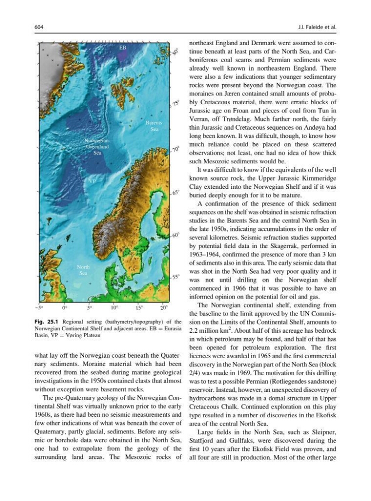
Fig. 25.1 Regional setting (bathymetry/topography) of the
Norwegian Continental Shelf and adjacent areas. EB ¼ Eurasia
Basin, VP ¼ Vøring Plateau
604
J.I. Faleide et al.
recovered from the seabed during marine geological
investigations in the 1950s contained clasts that almost
without exception were basement rocks.
The pre-Quaternary geology of the Norwegian Continental Shelf was virtually unknown prior to the early
1960s, as there had been no seismic measurements and
few other indications of what was beneath the cover of
Quaternary, partly glacial, sediments. Before any seismic or borehole data were obtained in the North Sea,
one had to extrapolate from the geology of the
surrounding land areas. The Mesozoic rocks of
northeast England and Denmark were assumed to continue beneath at least parts of the North Sea, and Carboniferous coal seams and Permian sediments were
already well known in northeastern England. There
were also a few indications that younger sedimentary
rocks were present beyond the Norwegian coast. The
moraines on Jæren contained small amounts of probably Cretaceous material, there were erratic blocks of
Jurassic age on Froan and pieces of coal from Tun in
Verran, off Trøndelag. Much farther north, the fairly
thin Jurassic and Cretaceous sequences on Andøya had
long been known. It was difficult, though, to know how
much reliance could be placed on these scattered
observations; not least, one had no idea of how thick
such Mesozoic sediments would be.
lt was difficult to know if the equivalents of the well
known source rock, the Upper Jurassic Kimmeridge
Clay extended into the Norwegian Shelf and if it was
buried deeply enough for it to be mature.
A confirmation of the presence of thick sediment
sequences on the shelf was obtained in seismic refraction
studies in the Barents Sea and the central North Sea in
the late 1950s, indicating accumulations in the order of
several kilometres. Seismic refraction studies supported
by potential field data in the Skagerrak, performed in
1963–1964, confirmed the presence of more than 3 km
of sediments also in this area. The early seismic data that
was shot in the North Sea had very poor quality and it
was not until drilling on the Norwegian shelf
commenced in 1966 that it was possible to have an
informed opinion on the potential for oil and gas.
The Norwegian continental shelf, extending from
the baseline to the limit approved by the UN Commission on the Limits of the Continental Shelf, amounts to
2.2 million km
2
. About half of this acreage has bedrock
in which petroleum may be found, and half of that has
been opened for petroleum exploration. The first
licences were awarded in 1965 and the first commercial
discovery in the Norwegian part of the North Sea (block
2/4) was made in 1969. The motivation for this drilling
was to test a possible Permian (Rotliegendes sandstone)
reservoir. Instead, however, an unexpected discovery of
hydrocarbons was made in a domal structure in Upper
Cretaceous Chalk. Continued exploration on this play
type resulted in a number of discoveries in the Ekofisk
area of the central North Sea.
Large fields in the North Sea, such as Sleipner,
Statfjord and Gullfaks, were discovered during the
first 10 years after the Ekofisk Field was proven, and
all four are still in production. Most of the other large
–5 °
0°
5°
10°
15°
20 °
55 °
60 °
6 5 °
7 0 °
7 5 °
8 0 °
North
Sea
Barents
Sea
NorwegianGreenland
Sea
VP
EB
Fig. 25.1 Regional setting (bathymetry/topography) of the
Norwegian Continental Shelf and adjacent areas. EB ¼ Eurasia
Basin, VP ¼ Vøring Plateau
604
J.I. Faleide et al.