

be produced by several quite different geological phenomena. The position of the tadpole head shows the
amount of dip and the tail shows the direction of dip.
16.5.8.2 Uses of Dipmeter Logs
Dipmeter data reflect dip and azimuth of bedding.
Variations of these parameters down the boreholes
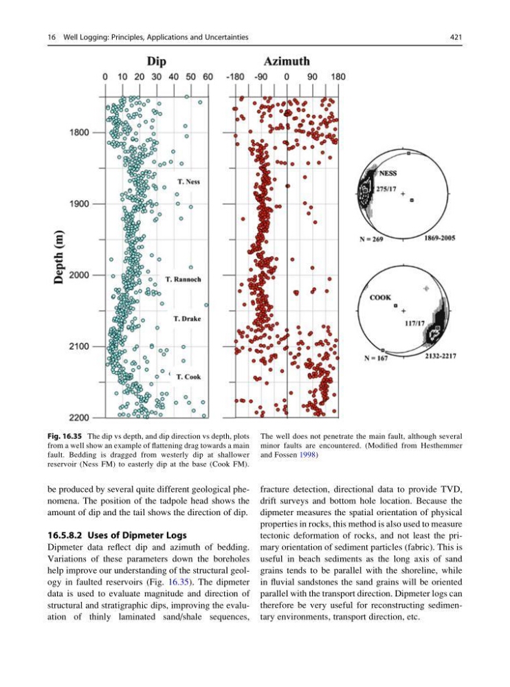
help improve our understanding of the structural geology in faulted reservoirs (Fig. 16.35). The dipmeter
data is used to evaluate magnitude and direction of
structural and stratigraphic dips, improving the evaluation of thinly laminated sand/shale sequences,
fracture detection, directional data to provide TVD,
drift surveys and bottom hole location. Because the
dipmeter measures the spatial orientation of physical
properties in rocks, this method is also used to measure
tectonic deformation of rocks, and not least the primary orientation of sediment particles (fabric). This is
useful in beach sediments as the long axis of sand
grains tends to be parallel with the shoreline, while
in fluvial sandstones the sand grains will be oriented
parallel with the transport direction. Dipmeter logs can
therefore be very useful for reconstructing sedimentary environments, transport direction, etc.
Fig. 16.35 The dip vs depth, and dip direction vs depth, plots
from a well show an example of flattening drag towards a main
fault. Bedding is dragged from westerly dip at shallower
reservoir (Ness FM) to easterly dip at the base (Cook FM).
The well does not penetrate the main fault, although several
minor faults are encountered. (Modified from Hesthemmer
and Fossen 1998)
16 Well Logging: Principles, Applications and Uncertainties
421
amount of dip and the tail shows the direction of dip.
16.5.8.2 Uses of Dipmeter Logs
Dipmeter data reflect dip and azimuth of bedding.
Variations of these parameters down the boreholes
help improve our understanding of the structural geology in faulted reservoirs (Fig. 16.35). The dipmeter
data is used to evaluate magnitude and direction of
structural and stratigraphic dips, improving the evaluation of thinly laminated sand/shale sequences,
fracture detection, directional data to provide TVD,
drift surveys and bottom hole location. Because the
dipmeter measures the spatial orientation of physical
properties in rocks, this method is also used to measure
tectonic deformation of rocks, and not least the primary orientation of sediment particles (fabric). This is
useful in beach sediments as the long axis of sand
grains tends to be parallel with the shoreline, while
in fluvial sandstones the sand grains will be oriented
parallel with the transport direction. Dipmeter logs can
therefore be very useful for reconstructing sedimentary environments, transport direction, etc.
Fig. 16.35 The dip vs depth, and dip direction vs depth, plots
from a well show an example of flattening drag towards a main
fault. Bedding is dragged from westerly dip at shallower
reservoir (Ness FM) to easterly dip at the base (Cook FM).
The well does not penetrate the main fault, although several
minor faults are encountered. (Modified from Hesthemmer
and Fossen 1998)
16 Well Logging: Principles, Applications and Uncertainties
421