

inhomogeneous and the contrasts in permeability
caused by clay layers and sand or gravel beds will
generally totally dominate the flow of water
(Fig. 10.5). While sand and gravel beds may have
permeabilities of 1–10 Darcy, the permeability of
poorly-compacted mud may be 0.01 mD or lower. In
such cases, mathematical modelling is of little value if
the stratigraphy, sedimentology and structural deformation of the sedimentary sequences are not interpreted correctly. Modelling can nevertheless help to
constrain some of the interpretations by calculating the
consequences of different alternatives.
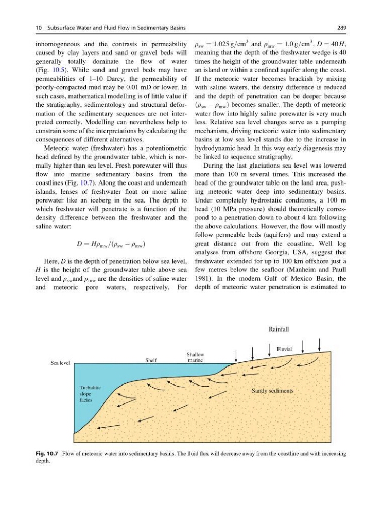
Meteoric water (freshwater) has a potentiometric
head defined by the groundwater table, which is normally higher than sea level. Fresh porewater will thus
flow into marine sedimentary basins from the
coastlines (Fig. 10.7). Along the coast and underneath
islands, lenses of freshwater float on more saline
porewater like an iceberg in the sea. The depth to
which freshwater will penetrate is a function of the
density difference between the freshwater and the
saline water:
D ¼ Hρ mw = ρ sw À ρ mw
ð
Þ
Here, D is the depth of penetration below sea level,
H is the height of the groundwater table above sea
level and ρ sw and ρ mw are the densities of saline water
and meteoric pore waters, respectively. For
ρ sw ¼ 1:025 g=cm
3 and ρ mw ¼ 1:0 g=cm
3 ; D ¼ 40 H,
meaning that the depth of the freshwater wedge is 40
times the height of the groundwater table underneath
an island or within a confined aquifer along the coast.
If the meteoric water becomes brackish by mixing
with saline waters, the density difference is reduced
and the depth of penetration can be deeper because
ρ sw À ρ mw
ð
Þbecomes smaller. The depth of meteoric
water flow into highly saline porewater is very much
less. Relative sea level changes serve as a pumping
mechanism, driving meteoric water into sedimentary
basins at low sea level stands due to the increase in
hydrodynamic head. In this way early diagenesis may
be linked to sequence stratigraphy.
During the last glaciations sea level was lowered
more than 100 m several times. This increased the
head of the groundwater table on the land area, pushing meteoric water deep into sedimentary basins.
Under completely hydrostatic conditions, a 100 m
head (10 MPa pressure) should theoretically correspond to a penetration down to about 4 km following
the above calculations. However, the flow will mostly
follow permeable beds (aquifers) and may extend a
great distance out from the coastline. Well log
analyses from offshore Georgia, USA, suggest that
freshwater extended for up to 100 km offshore just a
few metres below the seafloor (Manheim and Paull
1981). In the modern Gulf of Mexico Basin, the
depth of meteoric water penetration is estimated to
Sandy sediments
Sea level
Turbiditic
slope
facies
Shelf
Shallow
marine
Fluvial
Rainfall
Fig. 10.7 Flow of meteoric water into sedimentary basins. The fluid flux will decrease away from the coastline and with increasing
depth.
10 Subsurface Water and Fluid Flow in Sedimentary Basins
289
caused by clay layers and sand or gravel beds will
generally totally dominate the flow of water
(Fig. 10.5). While sand and gravel beds may have
permeabilities of 1–10 Darcy, the permeability of
poorly-compacted mud may be 0.01 mD or lower. In
such cases, mathematical modelling is of little value if
the stratigraphy, sedimentology and structural deformation of the sedimentary sequences are not interpreted correctly. Modelling can nevertheless help to
constrain some of the interpretations by calculating the
consequences of different alternatives.
Meteoric water (freshwater) has a potentiometric
head defined by the groundwater table, which is normally higher than sea level. Fresh porewater will thus
flow into marine sedimentary basins from the
coastlines (Fig. 10.7). Along the coast and underneath
islands, lenses of freshwater float on more saline
porewater like an iceberg in the sea. The depth to
which freshwater will penetrate is a function of the
density difference between the freshwater and the
saline water:
D ¼ Hρ mw = ρ sw À ρ mw
ð
Þ
Here, D is the depth of penetration below sea level,
H is the height of the groundwater table above sea
level and ρ sw and ρ mw are the densities of saline water
and meteoric pore waters, respectively. For
ρ sw ¼ 1:025 g=cm
3 and ρ mw ¼ 1:0 g=cm
3 ; D ¼ 40 H,
meaning that the depth of the freshwater wedge is 40
times the height of the groundwater table underneath
an island or within a confined aquifer along the coast.
If the meteoric water becomes brackish by mixing
with saline waters, the density difference is reduced
and the depth of penetration can be deeper because
ρ sw À ρ mw
ð
Þbecomes smaller. The depth of meteoric
water flow into highly saline porewater is very much
less. Relative sea level changes serve as a pumping
mechanism, driving meteoric water into sedimentary
basins at low sea level stands due to the increase in
hydrodynamic head. In this way early diagenesis may
be linked to sequence stratigraphy.
During the last glaciations sea level was lowered
more than 100 m several times. This increased the
head of the groundwater table on the land area, pushing meteoric water deep into sedimentary basins.
Under completely hydrostatic conditions, a 100 m
head (10 MPa pressure) should theoretically correspond to a penetration down to about 4 km following
the above calculations. However, the flow will mostly
follow permeable beds (aquifers) and may extend a
great distance out from the coastline. Well log
analyses from offshore Georgia, USA, suggest that
freshwater extended for up to 100 km offshore just a
few metres below the seafloor (Manheim and Paull
1981). In the modern Gulf of Mexico Basin, the
depth of meteoric water penetration is estimated to
Sandy sediments
Sea level
Turbiditic
slope
facies
Shelf
Shallow
marine
Fluvial
Rainfall
Fig. 10.7 Flow of meteoric water into sedimentary basins. The fluid flux will decrease away from the coastline and with increasing
depth.
10 Subsurface Water and Fluid Flow in Sedimentary Basins
289