

way to Alberta, Canada, where there are very large
deposits of heavy oil and tar sand. The heavy oil in
Venezuela (and Columbia) is located in a similar tectonic position in front of the Andes.
8.11 Strike-Slip Faults and Pull-Apart
Basins
We find “strike slip” faults in both the oceanic and the
continental crust. Transform faults in the oceanic crust
result in ridges of younger basaltic material which can
help to limit the extent of sedimentary basins, particularly in the early phases of the opening (see Chap. 6).
Strike-slip faults in the continental crust can lead to
both compression, i.e. thickening, forming small
mountains, and stretching of the continental crust
forming deep sedimentary basins. Calculations show
that relatively modest stretching of the continental
crust will cause considerable thinning and subsidence.
Bends in the strike-slip fault system like the San
Andreas Fault open up deep holes in the continental
crust which can be filled in with very thick sequences
of sediments like in the Ventura and Los Angeles
Basins. The sedimentation rate may be very high
because of the large uplifted land areas and the relatively small basins.
Here, too, relief which has developed through
stretching of the continental crust will be made more
pronounced by sediment loading and thermal subsidence. When two plates move parallel to one another,
we have strike-slip faults of the San Andreas type in
California, but there is no new plate formation, nor any
subduction. We distinguish between “right-lateral” or
“dextral” faults, where the opposite side of the fault
has moved to the right, and “left-lateral” or “sinistral”
faults. The San Andreas is a dextral fault, and the
western part of California (Salina block) has moved
northward in relation to the North American continent.
If the fault plane follows a completely straight structure in the rock parallel with the direction of movement there will be neither tension nor compression
along the fault plane. However, faults usually follow
older structures in the basement rocks which may be
curved and strike slip movements may then produce
both compression and tension along the fault plane.
Compression will lead to folding and the formation of
small mountain ranges, while tension will lead to the
opening of deep sedimentary basins.
We find the most typical examples of this in
California. When a fault branches we may also see
both compression and tension, with elevation and subsidence respectively of blocks, depending on their
orientation. If the fault shifts to another parallel fault
plane, we have crustal tension in the area in between,
and often also basalt flows. A so-called “pull-apart”
basin forms, which is a “hole” in the continental crust
formed by the strike slip movement. The Salten
Overthickened
continental crust 35–80 km
Continental
crust 30 km
Thinned
continental crust
Oceanic crust
Mountain chain
ρ = 2.8 g/cm
3
ρ = 1.03 g/cm
3
ρ = 2.9 g/cm
3
ρ = 1.7–2.6 g/cm
3
ρ = 3.3 g/cm
3
Hinge zone
S y n - r if t
Post-rift
Mantle
Passive margin
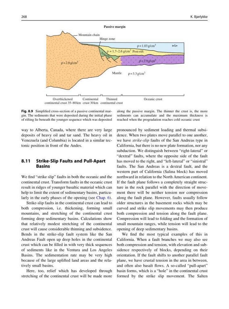
Fig. 8.9 Simplified cross-section of a passive continental margin. The sediments that were deposited during the initial phase
of rifting lie beneath the younger sequence which was deposited
along the passive margin. The thinner the crust is, the more
sediments can accumulate and the maximum thickness is
reached when the progradation reaches cold oceanic crust
268
K. Bjørlykke
deposits of heavy oil and tar sand. The heavy oil in
Venezuela (and Columbia) is located in a similar tectonic position in front of the Andes.
8.11 Strike-Slip Faults and Pull-Apart
Basins
We find “strike slip” faults in both the oceanic and the
continental crust. Transform faults in the oceanic crust
result in ridges of younger basaltic material which can
help to limit the extent of sedimentary basins, particularly in the early phases of the opening (see Chap. 6).
Strike-slip faults in the continental crust can lead to
both compression, i.e. thickening, forming small
mountains, and stretching of the continental crust
forming deep sedimentary basins. Calculations show
that relatively modest stretching of the continental
crust will cause considerable thinning and subsidence.
Bends in the strike-slip fault system like the San
Andreas Fault open up deep holes in the continental
crust which can be filled in with very thick sequences
of sediments like in the Ventura and Los Angeles
Basins. The sedimentation rate may be very high
because of the large uplifted land areas and the relatively small basins.
Here, too, relief which has developed through
stretching of the continental crust will be made more
pronounced by sediment loading and thermal subsidence. When two plates move parallel to one another,
we have strike-slip faults of the San Andreas type in
California, but there is no new plate formation, nor any
subduction. We distinguish between “right-lateral” or
“dextral” faults, where the opposite side of the fault
has moved to the right, and “left-lateral” or “sinistral”
faults. The San Andreas is a dextral fault, and the
western part of California (Salina block) has moved
northward in relation to the North American continent.
If the fault plane follows a completely straight structure in the rock parallel with the direction of movement there will be neither tension nor compression
along the fault plane. However, faults usually follow
older structures in the basement rocks which may be
curved and strike slip movements may then produce
both compression and tension along the fault plane.
Compression will lead to folding and the formation of
small mountain ranges, while tension will lead to the
opening of deep sedimentary basins.
We find the most typical examples of this in
California. When a fault branches we may also see
both compression and tension, with elevation and subsidence respectively of blocks, depending on their
orientation. If the fault shifts to another parallel fault
plane, we have crustal tension in the area in between,
and often also basalt flows. A so-called “pull-apart”
basin forms, which is a “hole” in the continental crust
formed by the strike slip movement. The Salten
Overthickened
continental crust 35–80 km
Continental
crust 30 km
Thinned
continental crust
Oceanic crust
Mountain chain
ρ = 2.8 g/cm
3
ρ = 1.03 g/cm
3
ρ = 2.9 g/cm
3
ρ = 1.7–2.6 g/cm
3
ρ = 3.3 g/cm
3
Hinge zone
S y n - r if t
Post-rift
Mantle
Passive margin
Fig. 8.9 Simplified cross-section of a passive continental margin. The sediments that were deposited during the initial phase
of rifting lie beneath the younger sequence which was deposited
along the passive margin. The thinner the crust is, the more
sediments can accumulate and the maximum thickness is
reached when the progradation reaches cold oceanic crust
268
K. Bjørlykke