

Sheet Reservoirs (SH Type)
LITHPERMEABILI1Y
OLOGY
POROSI1Y
2000
DEPOSITIONAL
ENVIRONMENT
Transgressive
Marine
Deposits
Stacked, Distal
Fluvial Channel
Deposits
Floodplain
Deposits
Stacked, Mid-Braided Stream
Fluvial Channel Deposits
Mld·Distal Fluvial
Channel Deposits
Floodplain Deposits
wlth Isolated
Channel Units
Distal Fluvial / Delta Mouth·
bar Deposits
Delta-Front Deposits
507
6
16
kh (md)
¢(%)
2.
3.02
ILD
2000
LEGEND
llf0JEZll:ITJII
•····················-········
10.
CALl
110.
;;o:·······RH
..-�---or----- _,. .. .. ........ cc.s · · .. .. ·· -···•
GQ S! GSM
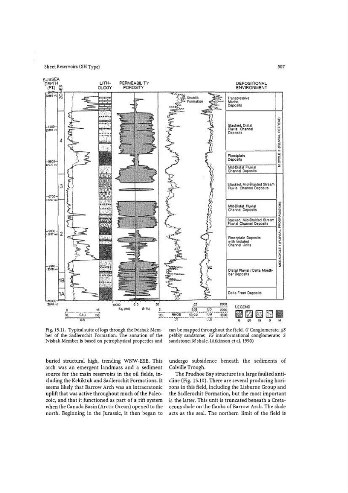
Fig. 15.11. Typical suite of logs through the Ivishak Member of the Sadlerochit Formation. The zonation of the
Ivishak Member is based on petrophysical properties and
buried structural high, trending WNW-ESE. This
arch was an emergent landmass and a sediment
source for the main reservoirs in the oil fields, including the Kekiktuk and Sadlerochit Formations. It
seems likely that Barrow Arch was an intracratonic
uplift that was active throughout much of the Paleozoic, and that it functioned as part of a rift system
when the Canada Basin (Arctic Ocean) opened to the
north. Beginning in the Jurassic, it then began to
can be mapped throughout the field. G Conglomerate; gS
pebbly sandstone; IG intraformational conglomerate; S
sandstone; M shale. (Atkinson et al. 1990)
undergo subsidence beneath the sediments of
Colville Trough.
The Prudhoe Bay structure is a large faulted anticline (Fig. 15.10). There are several producing horizons in this field1 including the Lisburne Group and
the Sadlerochit Formation, but the most important
is the latter. This unit is truncated beneath a Cretaceous shale on the flanks of Barrow Arch. The shale
acts as the seal. The northern limit of the field is