

paleovalley Fields (PV Type)
R 63 W
R 62 W
•
•
•
"
cRoSs
IN '
•\
SECTKm
�,... .. . ..--;- '
•
•
.--; -
)�
; r •
. . ,
•
�
•
"
:Z ENITH
• FI ELD
�· .
/
(' .
/
"
/"
••
v.
�
\J
I
I
t-/
C--- - ; , �
@® 1 0
•• fi
._;;;
,. \._
�
0
®
!�2±-r+s.... ._ _ -... .. �
•
•)
"
..
�o
-
. '
� 1 �
"
,j •
.
,� 'eo
�
�
}"
I
IY "' / �'<
"/ '
"
® / sTf:sauRG
/
FIELD
•
A
ISOPACH HUM!Siii AN
C.l.:: 10f'l
•
R 63 W
R 62 W
8
ISOPACH D SAMDSTOH!
•
c
R 601 W
R 62 W
�
@ 0 Prod�CI:H"
�) J Prod�e�r
{- Dry Hokl
CJ."' 10f'l
C.!. 10f\
T
3
s
50!
15.2.2 Cut Bank Sandstone, Montana
The Cut Bank field is located in northernmost Mon�
tana, adjacent to the border with Alberta. The geological setting is that of the Rocky Mountain
foreland basin, a southward extension of the Alberta
Basin. The Cut Bank field produces from meandering channels fllling a broad paleovalley at the base of
the Kootenai Formation, which is the Montana
equivalent of the Lower Mannville Group of Alberta .
The producing beds are incised into Jurassic strata.
The field is located on the west fl ank of the
Sweetgrass Arch. Regional drainage was to the north.
This paleovalley is considered to be a southward
extension of the major drainage systems that have
been identified in Alberta [the Spirit River Channel
of McLean and Wall (1981); see Fig. 11.25].
The valley is more than 50 km wide (Blixt 1941;
Conybeare 1976). The Cut Bank Sandstone is up to 70
m thick in outcrop, to the west of the field, but within
the field itself it has a maximum thickness of 25 m.
The dominant lithology is medium-grained, crossbedded sandstone showing an upward decrease in
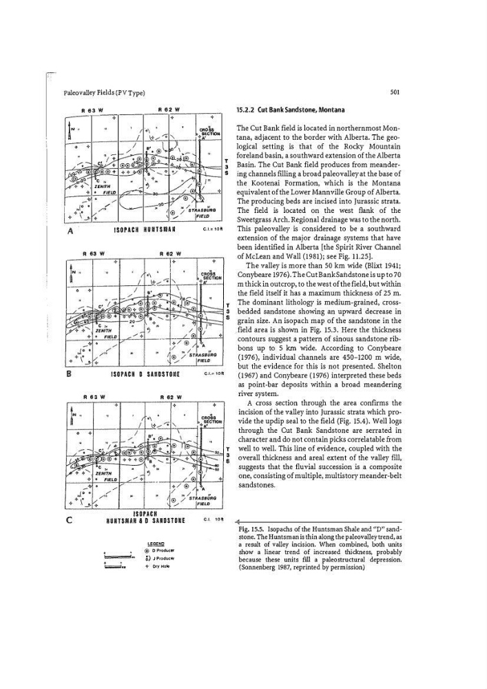
grain size. An isopach map of the sandstone in the
field area is shown in Fig. 15.3. Here the thickness
contours suggest .a pattern of sino us sandstone rib�
bans up to 5 km wide. According to Conybeare
(1976), individual channels are 450-1200 m wide,
but the evidence for this is not presented. Shelton
(1967) and Conybeare (1976) interpreted these beds
as point�bar deposits within a broad meandering
river system.
A cross section through the area confirms the
incision of the valley into Jurassic strata which provide the updip seal to the field (Fig. 15.4). Well logs
through the Cut Bank Sandstone are serrated in
character and do not contain picks correlatable from
well to well. This line of evi dence, coupled with the
overall thickness and areal extent of the valley fill,
suggests that the fluvial succession is a composite
one, consisting of multiple, multistory meander�belt
sandstones.
Fig. 15.5. Isopachs of the Huntsman Shale and '(P'' sand�
stone. The Huntsman is thin along the paleovalley trend, as
a result of valley incision. When combined, both units
show a linear trend of increased thickness, probably
because these units fill a paleostructural depression.
(Sonnenberg 1987, reprinted by permission)
R 63 W
R 62 W
•
•
•
"
cRoSs
IN '
•\
SECTKm
�,... .. . ..--;- '
•
•
.--; -
)�
; r •
. . ,
•
�
•
"
:Z ENITH
• FI ELD
�· .
/
(' .
/
"
/"
••
v.
�
\J
I
I
t-/
C--- - ; , �
@® 1 0
•• fi
._;;;
,. \._
�
0
®
!�2±-r+s.... ._ _ -... .. �
•
•)
"
..
�o
-
. '
� 1 �
"
,j •
.
,� 'eo
�
�
}"
I
IY "' / �'<
"/ '
"
® / sTf:sauRG
/
FIELD
•
A
ISOPACH HUM!Siii AN
C.l.:: 10f'l
•
R 63 W
R 62 W
8
ISOPACH D SAMDSTOH!
•
c
R 601 W
R 62 W
�
@ 0 Prod�CI:H"
�) J Prod�e�r
{- Dry Hokl
CJ."' 10f'l
C.!. 10f\
T
3
s
50!
15.2.2 Cut Bank Sandstone, Montana
The Cut Bank field is located in northernmost Mon�
tana, adjacent to the border with Alberta. The geological setting is that of the Rocky Mountain
foreland basin, a southward extension of the Alberta
Basin. The Cut Bank field produces from meandering channels fllling a broad paleovalley at the base of
the Kootenai Formation, which is the Montana
equivalent of the Lower Mannville Group of Alberta .
The producing beds are incised into Jurassic strata.
The field is located on the west fl ank of the
Sweetgrass Arch. Regional drainage was to the north.
This paleovalley is considered to be a southward
extension of the major drainage systems that have
been identified in Alberta [the Spirit River Channel
of McLean and Wall (1981); see Fig. 11.25].
The valley is more than 50 km wide (Blixt 1941;
Conybeare 1976). The Cut Bank Sandstone is up to 70
m thick in outcrop, to the west of the field, but within
the field itself it has a maximum thickness of 25 m.
The dominant lithology is medium-grained, crossbedded sandstone showing an upward decrease in
grain size. An isopach map of the sandstone in the
field area is shown in Fig. 15.3. Here the thickness
contours suggest .a pattern of sino us sandstone rib�
bans up to 5 km wide. According to Conybeare
(1976), individual channels are 450-1200 m wide,
but the evidence for this is not presented. Shelton
(1967) and Conybeare (1976) interpreted these beds
as point�bar deposits within a broad meandering
river system.
A cross section through the area confirms the
incision of the valley into Jurassic strata which provide the updip seal to the field (Fig. 15.4). Well logs
through the Cut Bank Sandstone are serrated in
character and do not contain picks correlatable from
well to well. This line of evi dence, coupled with the
overall thickness and areal extent of the valley fill,
suggests that the fluvial succession is a composite
one, consisting of multiple, multistory meander�belt
sandstones.
Fig. 15.5. Isopachs of the Huntsman Shale and '(P'' sand�
stone. The Huntsman is thin along the paleovalley trend, as
a result of valley incision. When combined, both units
show a linear trend of increased thickness, probably
because these units fill a paleostructural depression.
(Sonnenberg 1987, reprinted by permission)