

474
13.3.4 Equivalent of Maximum Flooding Surface
The maximum flooding surface (MFS) is represented by the maximum landward extent of marine
deposits; it is immediately followed by the highstand
systems tract (Vail et al. 1977; Vail 1987). In marine
deposits the surface may be represented by a condensed section (Loutit et al. 1988). Typically,
highstand deposits such as regressive delta and
coastal barrier-strandplain systems prograde seaward, developing a downlap relationship to the MFS.
This downlap architecture is a distinctive fe ature of
seismic cross sections (Vail et al. 1977; Vail l987).
Galloway (1989a) argued that the MFS is commonly a
more readily mappable surface than a subaerial erosion surface, and he recommended using the MFS as
the sequence boundary. To distinguish such sequences fr om those of Vail and his colleagues he
termed them genetic stratigraphic se q uences. This
usage has been followed by some recent workers. For
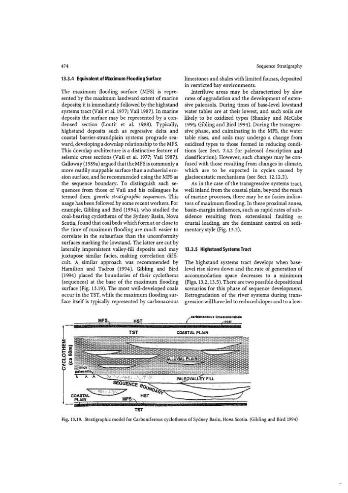
example, Gibling and Bird (1994), who studied the
coal-bearing cyclothems of the Sydney Basin, Nova
Scotia, found that coal beds which form at or close to
the time of maximum flooding are much easier to
correlate in the subsurface than the unconformity
surfaces marking the lowstand. The latter are cut by
laterally impersistent valley-fill deposits and may
juxtapose similar facies, making correlation difficult. A similar approach was recommended by
Hamilton and Tadros (1994). Gibling and Bird
(1994) placed the boundaries of their cyclothems
(sequences) at the base of the maximum flooding
surface (Fig. 13.19). The most well-developed coals
occur in the TST, while the maximum flooding surface itself is typically represented by carbonaceous
MFS,
I
HST
Sequence Stratigraphy
limestones and shales with limited faunas, deposited
in restricted bay environments.
Interfluve areas may be characterized by slow
rates of aggradation and the development of extensive paleosols. During times of base-level lowstand
water tables are at their lowest, and such soils are
likely to be oxidized types (Shanley and McCabe
1994; Gibling and Bird 1994). During the transgressive phase, and culminating in the MFS, the water
table rises, and soils may undergo a change from
oxidized types to those formed in reducing conditions (see Sect. 7.4.2 for paleosol description and
classification). However, such changes may be confu sed with those resulting from changes in climate,
which are to be expected in cycles_ caused by
glacioeustatic mechanisms (see Sect. 12.12.2).
As in the case of the transgressive systems tract,
well inland from the coastal plain, beyond the reach
of marine processes, there may be no facies indicators of maximum flooding. In these proximal zones,
basin-margin influences, such as rapid rates of subsidence resulting from extensional faulting or
crustal loading, are the dominant control on sedimentary style (Fig. 13.3).
13.3.5 Highstand Systems Tract
The highstand systems tract develops when baselevel rise slows down and the xate of generation of
accommodation space decreases to a minimum
(Figs. 13.2, 13.5). There are two possible depositional
scenarios for this phase of sequence development.
Retrogradation of the river systems during transgression will have led to reduced slopes and to a low{carbonaceous !lm&stone/shale
...- coal
'
1
TST
COASTAL PLAIN
:::!
w:c E
1-o
0"'
.... "
(.) "
>(.)
TST
Fig. 13.19. Stratigraphic model for Carboniferous cyclothems of Sydney Basin, Nova Scotia. (Gibling and Bird 1994)
13.3.4 Equivalent of Maximum Flooding Surface
The maximum flooding surface (MFS) is represented by the maximum landward extent of marine
deposits; it is immediately followed by the highstand
systems tract (Vail et al. 1977; Vail 1987). In marine
deposits the surface may be represented by a condensed section (Loutit et al. 1988). Typically,
highstand deposits such as regressive delta and
coastal barrier-strandplain systems prograde seaward, developing a downlap relationship to the MFS.
This downlap architecture is a distinctive fe ature of
seismic cross sections (Vail et al. 1977; Vail l987).
Galloway (1989a) argued that the MFS is commonly a
more readily mappable surface than a subaerial erosion surface, and he recommended using the MFS as
the sequence boundary. To distinguish such sequences fr om those of Vail and his colleagues he
termed them genetic stratigraphic se q uences. This
usage has been followed by some recent workers. For
example, Gibling and Bird (1994), who studied the
coal-bearing cyclothems of the Sydney Basin, Nova
Scotia, found that coal beds which form at or close to
the time of maximum flooding are much easier to
correlate in the subsurface than the unconformity
surfaces marking the lowstand. The latter are cut by
laterally impersistent valley-fill deposits and may
juxtapose similar facies, making correlation difficult. A similar approach was recommended by
Hamilton and Tadros (1994). Gibling and Bird
(1994) placed the boundaries of their cyclothems
(sequences) at the base of the maximum flooding
surface (Fig. 13.19). The most well-developed coals
occur in the TST, while the maximum flooding surface itself is typically represented by carbonaceous
MFS,
I
HST
Sequence Stratigraphy
limestones and shales with limited faunas, deposited
in restricted bay environments.
Interfluve areas may be characterized by slow
rates of aggradation and the development of extensive paleosols. During times of base-level lowstand
water tables are at their lowest, and such soils are
likely to be oxidized types (Shanley and McCabe
1994; Gibling and Bird 1994). During the transgressive phase, and culminating in the MFS, the water
table rises, and soils may undergo a change from
oxidized types to those formed in reducing conditions (see Sect. 7.4.2 for paleosol description and
classification). However, such changes may be confu sed with those resulting from changes in climate,
which are to be expected in cycles_ caused by
glacioeustatic mechanisms (see Sect. 12.12.2).
As in the case of the transgressive systems tract,
well inland from the coastal plain, beyond the reach
of marine processes, there may be no facies indicators of maximum flooding. In these proximal zones,
basin-margin influences, such as rapid rates of subsidence resulting from extensional faulting or
crustal loading, are the dominant control on sedimentary style (Fig. 13.3).
13.3.5 Highstand Systems Tract
The highstand systems tract develops when baselevel rise slows down and the xate of generation of
accommodation space decreases to a minimum
(Figs. 13.2, 13.5). There are two possible depositional
scenarios for this phase of sequence development.
Retrogradation of the river systems during transgression will have led to reduced slopes and to a low{carbonaceous !lm&stone/shale
...- coal
'
1
TST
COASTAL PLAIN
:::!
w:c E
1-o
0"'
.... "
(.) "
>(.)
TST
Fig. 13.19. Stratigraphic model for Carboniferous cyclothems of Sydney Basin, Nova Scotia. (Gibling and Bird 1994)