

Main Components of the Fluvial Sequence Model
China, incised valleys up to 300 m deep have been
mapped (Moore et a!. 1986; Song Guochu 1988).
Most of the world's large rivers occupy the fill of
canyons incised into the continental margin during
glacial sea-level lowstands (e.g., Fisk 1944).
Individual paleovalleys can commonly be traced
along the valley axis for many kilometers in the
subsurface, as in the case of the Mannville Group
valleys of Alberta (Wood and Hopkins 1989, 1992;
Fig. 15.1) and those filled with the '')" sandstone in
the Denver Basin (Harms 1966). Paleovalleys are
associated with considerable stratigraphic relief and
lateral facies changes, and this may make for difficulties in correlation between valley fills in both the
surface and the subsurface (e.g., Gibling and Bird
1994). As Galloway (1989a) pointed out, this is one
good reason for defining sequence boundaries in
nonmarine deposits at the nonmarine equivalent of
the maximum flooding surface, a proposal followed
by Gibling and Bird (1994; see Sect. 13.3.4). In many
cases, extensive networks of channels may be
present on unconformity surfaces, in which individual channels are commonly incised tens of meters
into the substrate (Hopkins 1981; Aubry 1989). In
some cases the channel fills merge laterally to form
extensive sheet sandstone bodies separated by interfluves, such as the lowstand deposits of the Gulf
Coast Shelf off Texas and Louisiana (Suter et a!.
1987). Here, the subsurface data base is adequate for
the mapping of individual valleys (Fig. 13.12).
In some cases cases the mobile channel belts in
which the lowstand deposits are formed merge laterally, to form broad sheets that are continuous across
112 MlLE
4
467
strike and lack mappable interfluves. The lower
Castlegate Sandstone of Utah (Fig. 9.18) is a good
example (Fouch et a!. 1983; Yoshida et a!., in press).
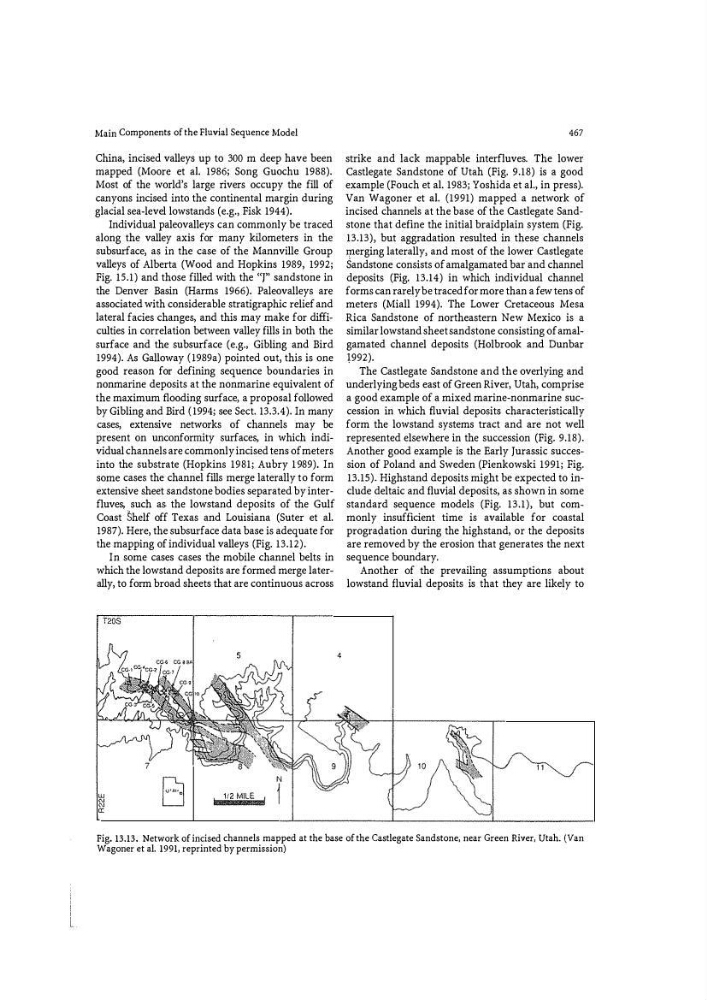
Van Wagoner et a!. (1991) mapped a network of
incised channels at the base of the Castlegate Sandstone that define the initial braidplain system (Fig.
13.13), but aggradation resulted in these channels
l.Jlerging laterally, and most of the lower Castlegate
Sandstone consists of amalgamated bar and channel
deposits (Fig. 13.14) in which individual channel
forms can rarely be traced for more than a few tens of
meters (Miall 1994). The Lower Cretaceous Mesa
Rica Sandstone of northeastern New Mexico is a
similar lowstand sheet sandstone consisting of amalgamated channel deposits (Holbrook and Dunbar
!992).
The Castlegate Sandstone and the overlying and
underlying beds east of Green River, Utah, comprise
a good example of a mixed marine-nonmarine succession in which fluvial deposits characteristically
form the lowstand systems tract and are not well
represented elsewhere in the succession (Fig. 9.18).
Another good example is the Early Jurassic succession of Poland and Sweden (Pienkowski 1991; Fig.
13.15). Highstand deposits might be expected to include deltaic and fluvial deposits, as shown in some
standard sequence models (Fig. 13.1), but commonly insufficient time is available for coastal
progra9.ation during the highstand, or the deposits
are removed by the erosion that generates the next
sequence boundary.
Another of the prevailing assumptions about
lowstand fluvial deposits is that they are likely to
Fig. 13.13. Network of incised channels mapped at the base of the Castlegate Sandstone, near Green River, Utah. (Van
Wagoner et al. 1991, reprinted by permission)
China, incised valleys up to 300 m deep have been
mapped (Moore et a!. 1986; Song Guochu 1988).
Most of the world's large rivers occupy the fill of
canyons incised into the continental margin during
glacial sea-level lowstands (e.g., Fisk 1944).
Individual paleovalleys can commonly be traced
along the valley axis for many kilometers in the
subsurface, as in the case of the Mannville Group
valleys of Alberta (Wood and Hopkins 1989, 1992;
Fig. 15.1) and those filled with the '')" sandstone in
the Denver Basin (Harms 1966). Paleovalleys are
associated with considerable stratigraphic relief and
lateral facies changes, and this may make for difficulties in correlation between valley fills in both the
surface and the subsurface (e.g., Gibling and Bird
1994). As Galloway (1989a) pointed out, this is one
good reason for defining sequence boundaries in
nonmarine deposits at the nonmarine equivalent of
the maximum flooding surface, a proposal followed
by Gibling and Bird (1994; see Sect. 13.3.4). In many
cases, extensive networks of channels may be
present on unconformity surfaces, in which individual channels are commonly incised tens of meters
into the substrate (Hopkins 1981; Aubry 1989). In
some cases the channel fills merge laterally to form
extensive sheet sandstone bodies separated by interfluves, such as the lowstand deposits of the Gulf
Coast Shelf off Texas and Louisiana (Suter et a!.
1987). Here, the subsurface data base is adequate for
the mapping of individual valleys (Fig. 13.12).
In some cases cases the mobile channel belts in
which the lowstand deposits are formed merge laterally, to form broad sheets that are continuous across
112 MlLE
4
467
strike and lack mappable interfluves. The lower
Castlegate Sandstone of Utah (Fig. 9.18) is a good
example (Fouch et a!. 1983; Yoshida et a!., in press).
Van Wagoner et a!. (1991) mapped a network of
incised channels at the base of the Castlegate Sandstone that define the initial braidplain system (Fig.
13.13), but aggradation resulted in these channels
l.Jlerging laterally, and most of the lower Castlegate
Sandstone consists of amalgamated bar and channel
deposits (Fig. 13.14) in which individual channel
forms can rarely be traced for more than a few tens of
meters (Miall 1994). The Lower Cretaceous Mesa
Rica Sandstone of northeastern New Mexico is a
similar lowstand sheet sandstone consisting of amalgamated channel deposits (Holbrook and Dunbar
!992).
The Castlegate Sandstone and the overlying and
underlying beds east of Green River, Utah, comprise
a good example of a mixed marine-nonmarine succession in which fluvial deposits characteristically
form the lowstand systems tract and are not well
represented elsewhere in the succession (Fig. 9.18).
Another good example is the Early Jurassic succession of Poland and Sweden (Pienkowski 1991; Fig.
13.15). Highstand deposits might be expected to include deltaic and fluvial deposits, as shown in some
standard sequence models (Fig. 13.1), but commonly insufficient time is available for coastal
progra9.ation during the highstand, or the deposits
are removed by the erosion that generates the next
sequence boundary.
Another of the prevailing assumptions about
lowstand fluvial deposits is that they are likely to
Fig. 13.13. Network of incised channels mapped at the base of the Castlegate Sandstone, near Green River, Utah. (Van
Wagoner et al. 1991, reprinted by permission)