

352
•
0
I ------- ----NMh
Paleo·lndus River
•
c
50
Km
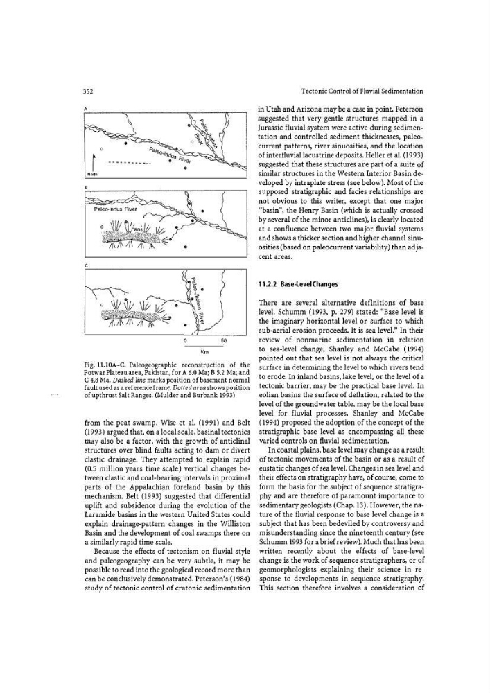
Fig. U.IOA-C. Paleogeographic reconstn.1ction of the
Potwar Plateau area, Pakistan, for A 6.0 Ma; B 5.2 Ma; and
C 4.8 Ma. Dashed line marks position of basement normal
fault used as a reference frame. Dotted area shows position
Qf upthrust Salt Ranges. (Mulder and Burbank 1993)
from the peat swamp. Wise et al. (1991) and Belt
(1993) argued that, on a local scale, basinal tectonics
may also be a factor, with the growth of anticlinal
structures over blind faults acting to dam or divert
clastic drainage. They attempted to explain rapid
(0.5 million years time scale) vertical changes between clastic and coal-bearing intervals in proximal
parts of the Appalachian foreland basin by this
mechanism. Belt (1993) suggested that differential
uplift and subsidence during the evolution of the
Laramide basins in the western United States could
explain drainage-pattern changes in the Williston
Ba$in and the development of coal swamps there on
a similarly ra p id time scale.
Because the effects of tectonism on fluvial style
and paleogeography can be very subtle, it may be
possible to read into the geological record more than
can be conclu$ively demonstrated. Peterson's (1984)
study of tectonic control of cratonic se
in Utah and Arizona may be a case in point. Peterson
suggested that very gentle structures mapped in a
Jurassic fluvial system were active during sedimentation and controlled sediment thicknesses, paleocurrent patterns, river sinuosities, and the location
of interfluvial lacustrine deposits. Heller et al. (1993)
suggested that these structures are part of a suite of
similar structures in the Western Interior Basin developed by intraplate stress (see below). Most of the
supposed stratigraphic and facies relationships are
not obvious to this writer, except that one major
'(basin", the Henry Basin (which is actually crossed
by several of the minor anticlines), is clearly located
at a confluence between two major fluvial systems
and shows a thicker section and higher channel sinuosities (based on paleocurrent variability) than adjacent areas.
11.2.2 Base-Level Changes
There are several alternative definitions of base
level. Schumm (1993, p. 279) stated: "Base level is
the imaginary horizontal level or surface to which
sub-aerial erosion proceeds. It is sea level." In their
review of nonmarine sedimentation in relation
to sea-level change, Shanley and McCabe (1994)
pointed out that sea level is not always the critical
surface in 4etermining the level to which rivers tend
to erode. In inland basins, lake level, or the level of a
tectonic barrier, may be the practical base level. In
eolian basins the surface of deflation, related to the
level of the groundwater table, may be the local base
level for fluvial processes. Shanley and McCabe
(1994) proposed the adoption of the concept of the
stratigraphic base level as encompassing all these
varied controls on fluvial sedimentation.
In coastal plains, base level may change as a result
of tectonic movements of the basin or as a result of
eust<;ltic changes of sea level. Changes in sea level and
their effects on stratigraphy have, of course, come to
form the basis for the subject of sequence stratigraphy and are therefore of paramount importance to
sedimentary geologists (Chap. 13). However, the nature of the fluvial response to base level change i$ a
subject that has been bedeviled by controversy and
misunderstanding since the nineteenth century (s�e
Schumm 1993 for a brief review). Much that has been
written recently about the effects of base-level
change is the work of sequence stratigraphers, or of
geomorphologists explaining their science in response to developments in sequence stratigraphy.
This section therefore involves a consideration of
•
0
I ------- ----NMh
Paleo·lndus River
•
c
50
Km
Fig. U.IOA-C. Paleogeographic reconstn.1ction of the
Potwar Plateau area, Pakistan, for A 6.0 Ma; B 5.2 Ma; and
C 4.8 Ma. Dashed line marks position of basement normal
fault used as a reference frame. Dotted area shows position
Qf upthrust Salt Ranges. (Mulder and Burbank 1993)
from the peat swamp. Wise et al. (1991) and Belt
(1993) argued that, on a local scale, basinal tectonics
may also be a factor, with the growth of anticlinal
structures over blind faults acting to dam or divert
clastic drainage. They attempted to explain rapid
(0.5 million years time scale) vertical changes between clastic and coal-bearing intervals in proximal
parts of the Appalachian foreland basin by this
mechanism. Belt (1993) suggested that differential
uplift and subsidence during the evolution of the
Laramide basins in the western United States could
explain drainage-pattern changes in the Williston
Ba$in and the development of coal swamps there on
a similarly ra p id time scale.
Because the effects of tectonism on fluvial style
and paleogeography can be very subtle, it may be
possible to read into the geological record more than
can be conclu$ively demonstrated. Peterson's (1984)
study of tectonic control of cratonic se
in Utah and Arizona may be a case in point. Peterson
suggested that very gentle structures mapped in a
Jurassic fluvial system were active during sedimentation and controlled sediment thicknesses, paleocurrent patterns, river sinuosities, and the location
of interfluvial lacustrine deposits. Heller et al. (1993)
suggested that these structures are part of a suite of
similar structures in the Western Interior Basin developed by intraplate stress (see below). Most of the
supposed stratigraphic and facies relationships are
not obvious to this writer, except that one major
'(basin", the Henry Basin (which is actually crossed
by several of the minor anticlines), is clearly located
at a confluence between two major fluvial systems
and shows a thicker section and higher channel sinuosities (based on paleocurrent variability) than adjacent areas.
11.2.2 Base-Level Changes
There are several alternative definitions of base
level. Schumm (1993, p. 279) stated: "Base level is
the imaginary horizontal level or surface to which
sub-aerial erosion proceeds. It is sea level." In their
review of nonmarine sedimentation in relation
to sea-level change, Shanley and McCabe (1994)
pointed out that sea level is not always the critical
surface in 4etermining the level to which rivers tend
to erode. In inland basins, lake level, or the level of a
tectonic barrier, may be the practical base level. In
eolian basins the surface of deflation, related to the
level of the groundwater table, may be the local base
level for fluvial processes. Shanley and McCabe
(1994) proposed the adoption of the concept of the
stratigraphic base level as encompassing all these
varied controls on fluvial sedimentation.
In coastal plains, base level may change as a result
of tectonic movements of the basin or as a result of
eust<;ltic changes of sea level. Changes in sea level and
their effects on stratigraphy have, of course, come to
form the basis for the subject of sequence stratigraphy and are therefore of paramount importance to
sedimentary geologists (Chap. 13). However, the nature of the fluvial response to base level change i$ a
subject that has been bedeviled by controversy and
misunderstanding since the nineteenth century (s�e
Schumm 1993 for a brief review). Much that has been
written recently about the effects of base-level
change is the work of sequence stratigraphers, or of
geomorphologists explaining their science in response to developments in sequence stratigraphy.
This section therefore involves a consideration of