

Avulsion in Fluvial Systems and Its Effect on Alluvial Stratigraphy
325
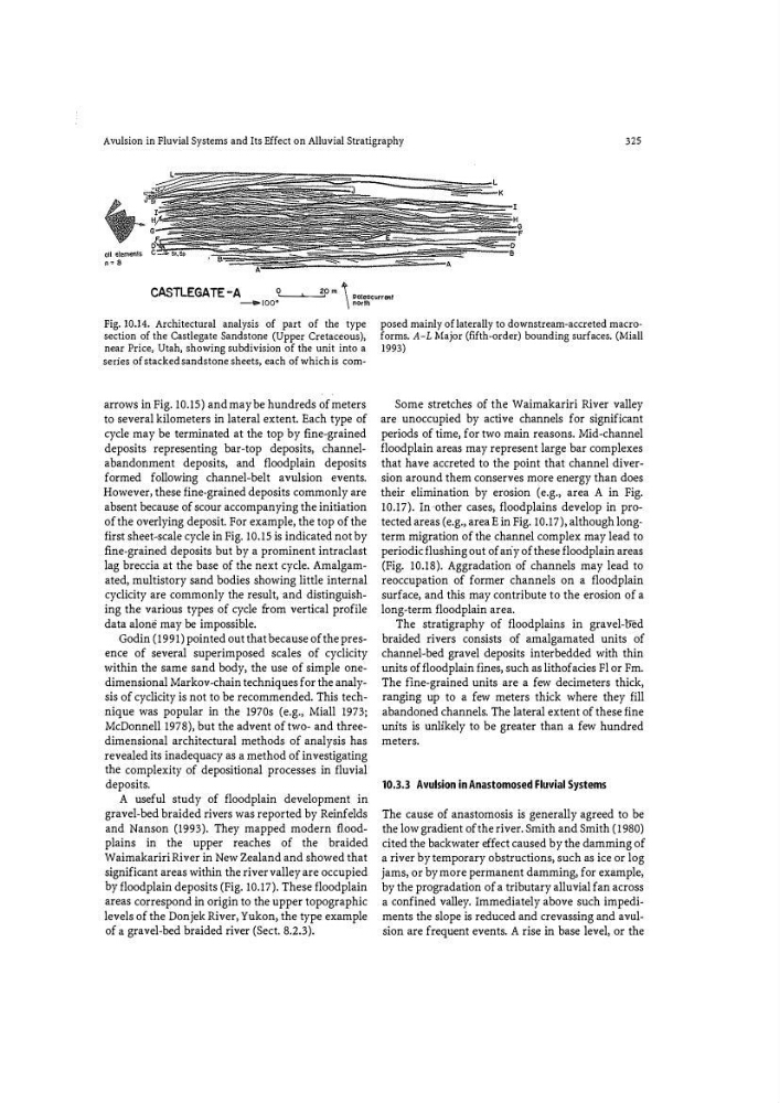
CASTLEGATE -A
0L_�--"2'0 m � poleoc:urrent
--.. !00"
\ north
Fig. 10.14. Architectural analysis of part of the type
section of the Castlegate Sandstone (Upper Cretaceous),
near Price, Utah, showing subdivision of the unit into a
series of stacked sandstone sheets, each of which is comarrows in Fig. 10.15) and may be hundreds of meters
to several kilometers in lateral extent. Each type of
cycle may be terminated at the top by fine-grained
deposits representing bar-top deposits, channelabandonment deposits, and floodplain deposits
formed following channel-belt avulsion events.
However, these fine-grained deposits commonly are
absent because of scour accompanying the initiation
of the overlying deposit. For example, the top of the
first sheet-scale cycle in Fig. 10.15 is indicated not by
fi ne-grained deposits but by a prominent intraclast
lag breccia at the base of the next cycle. Amalgamated, multistory sand bodies showing little internal
cyclicity are commonly the result, and distinguishing the various types of cycle fr om vertical profile
data alone may be impossible.
Godin (1991) pointed out that because of the presence of several superimposed scales of cyclicity
within the same sand body, the use of simple onedimensional Markov-chain techniques for the analysis of cyclicity is not to be recommended. This technique was popular in the 1970s (e.g., Miall 1973;
McDonnell 1978), but the advent of two- and threedimensional architectural methods of analysis has
revealed its inadequacy as a method of investigating
the complexity of depositional processes in fluvial
deposits.
A useful study of floodplain development in
gravel-bed braided rivers was reported by Reinfelds
and Nanson (1993). They mapped modern floodplains in the upper reaches of the braided
Waimakariri River in New Zealand and showed that
significant areas within the river valley are occupied
by floodplain deposits (Fig. 10.17). These floodplain
areas correspond in origin to the upper topographic
levels of the Donjek River, Yukon, the type example
of a gravel-bed braided river (Sect. 8.2.3).
posed mainly of laterally to downstream-accreted macro�
forms. A-L Major (fifth-order) bounding surfaces. (Miall
1993)
Some stretches of the Waimakariri River valley
are unoccupied by active channels for significant
periods of time, for two main reasons. Mid -channel
floodplain areas may represent large bar complexes
that have accreted to the point that channel diversion around them conserves more energy than does
their elimination by erosion (e.g., area A in Fig.
10.17). In other cases, floodplains develop in protected areas (e.g., area E in Fig. 10.17), although long�
term migration of the channel complex may lead to
periodic flushing out of ariy of these floodplain areas
(Fig. 10.18). Aggradation of channels may lead to
reoccupation of former channels on a floodplain
surface, and this may contribute to the erosion of a
long-term floodplain area.
The stratigraphy of floodplains in gravel-oM
braided rivers consists of amalgamated units of
channel-bed gravel deposits interbedded with thin
units of floodplain fines, such as lithofacies Fl or Fm.
The fine-grained units are a few decimeters thick,
ranging up to a few meters thick where they fill
abandoned channels. The lateral extent of these fine
units is unlikely to be greater than a few hundred
meters.
10.3.3 Avulsion in Anastomosed Fluvial Systems
The cause of anastomosis is generally agreed to be
the low gradient of the river. Smith and Smith (1980)
cited the backwater effect caused by the damming of
a river by temporary obstructions, such as ice or log
jams, or by more permanent damming, for example,
by the progradation of a tributary alluvial fan across
a confined valley. Immediately above such impediments the slope is reduced and crevassing and avulsion are frequent events. A rise in base level, or the
325
CASTLEGATE -A
0L_�--"2'0 m � poleoc:urrent
--.. !00"
\ north
Fig. 10.14. Architectural analysis of part of the type
section of the Castlegate Sandstone (Upper Cretaceous),
near Price, Utah, showing subdivision of the unit into a
series of stacked sandstone sheets, each of which is comarrows in Fig. 10.15) and may be hundreds of meters
to several kilometers in lateral extent. Each type of
cycle may be terminated at the top by fine-grained
deposits representing bar-top deposits, channelabandonment deposits, and floodplain deposits
formed following channel-belt avulsion events.
However, these fine-grained deposits commonly are
absent because of scour accompanying the initiation
of the overlying deposit. For example, the top of the
first sheet-scale cycle in Fig. 10.15 is indicated not by
fi ne-grained deposits but by a prominent intraclast
lag breccia at the base of the next cycle. Amalgamated, multistory sand bodies showing little internal
cyclicity are commonly the result, and distinguishing the various types of cycle fr om vertical profile
data alone may be impossible.
Godin (1991) pointed out that because of the presence of several superimposed scales of cyclicity
within the same sand body, the use of simple onedimensional Markov-chain techniques for the analysis of cyclicity is not to be recommended. This technique was popular in the 1970s (e.g., Miall 1973;
McDonnell 1978), but the advent of two- and threedimensional architectural methods of analysis has
revealed its inadequacy as a method of investigating
the complexity of depositional processes in fluvial
deposits.
A useful study of floodplain development in
gravel-bed braided rivers was reported by Reinfelds
and Nanson (1993). They mapped modern floodplains in the upper reaches of the braided
Waimakariri River in New Zealand and showed that
significant areas within the river valley are occupied
by floodplain deposits (Fig. 10.17). These floodplain
areas correspond in origin to the upper topographic
levels of the Donjek River, Yukon, the type example
of a gravel-bed braided river (Sect. 8.2.3).
posed mainly of laterally to downstream-accreted macro�
forms. A-L Major (fifth-order) bounding surfaces. (Miall
1993)
Some stretches of the Waimakariri River valley
are unoccupied by active channels for significant
periods of time, for two main reasons. Mid -channel
floodplain areas may represent large bar complexes
that have accreted to the point that channel diversion around them conserves more energy than does
their elimination by erosion (e.g., area A in Fig.
10.17). In other cases, floodplains develop in protected areas (e.g., area E in Fig. 10.17), although long�
term migration of the channel complex may lead to
periodic flushing out of ariy of these floodplain areas
(Fig. 10.18). Aggradation of channels may lead to
reoccupation of former channels on a floodplain
surface, and this may contribute to the erosion of a
long-term floodplain area.
The stratigraphy of floodplains in gravel-oM
braided rivers consists of amalgamated units of
channel-bed gravel deposits interbedded with thin
units of floodplain fines, such as lithofacies Fl or Fm.
The fine-grained units are a few decimeters thick,
ranging up to a few meters thick where they fill
abandoned channels. The lateral extent of these fine
units is unlikely to be greater than a few hundred
meters.
10.3.3 Avulsion in Anastomosed Fluvial Systems
The cause of anastomosis is generally agreed to be
the low gradient of the river. Smith and Smith (1980)
cited the backwater effect caused by the damming of
a river by temporary obstructions, such as ice or log
jams, or by more permanent damming, for example,
by the progradation of a tributary alluvial fan across
a confined valley. Immediately above such impediments the slope is reduced and crevassing and avulsion are frequent events. A rise in base level, or the