

292
The Stratigraphic Architecture of Fluvial Depositional Systems
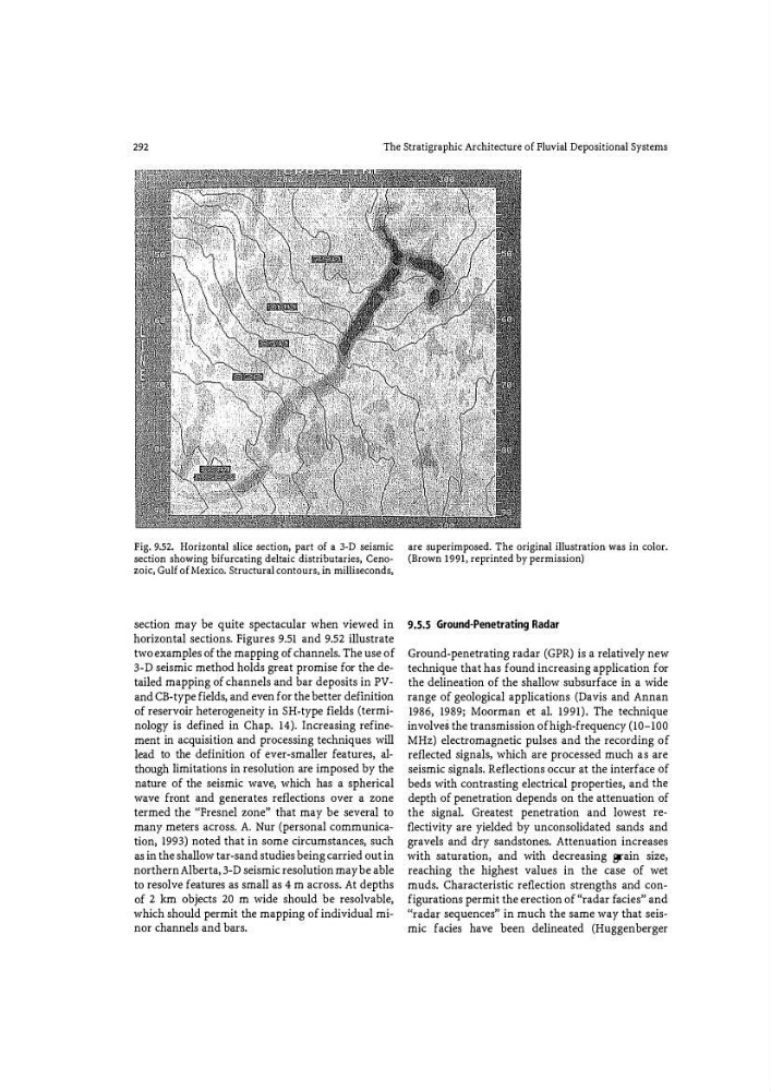
Fig. 9.52. Horizontal slice section, part of a 3-D seismic
section showing bifurcating deltaic distributaries, Cenozoic, Gulf of Mexico. Structural contours, in milliseconds,
section may be quite spectacular when viewed in
horizontal sections. Figures 9.51 and 9.52 illustrate
two examples of the mapping of channels. The use of
3-D seismic method holds great promise for the detailed mapping of channels and bar deposits in PVand CB-type fields, and even for the better definition
of reservoir heterogeneity in SH: -type fields (terminology is defined in Chap. 14). Increasing refinement in acquisition and processing techniques will
lead to the definition of ever-smaller features, although limitations in resolution are imposed by the
nature of the seismic wave, which has a spherical
wave front and generates reflections over a zone
termed the '(Fresnel zone» that may be several to
many meters across. A. Nur (personal communication, 1993) noted that in some circumstances, such
as in the shallow tar-sand studies being carried out in
northern Alberta, 3-D seismic resolution may be able
to resolve features as small as 4 m across. At depths
of 2 km objects 20 m wide should be resolvable,
which should permit the mapping of individual minor channels and bars.
are superimposed. The original illustration was in color.
(Brown 1991, reprinted by permission)
9.5.5 Ground-Penetrating Radar
Ground-penetrating radar (GPR) is a relatively new
technique that has found increasing application for
the delineation of the shallow subsurface in a wide
range of geological applications (Davis and Annan
1986, 1989; Moorman et al. 1991). The technique
involves the transmission ofhigh-frequency (10-100
MHz) electromagnetic pulses and the recording of
reflected signals, which are processed much as are
seismic signals. Reflections occur at the interface of
beds with contrasting electrical properties, and the
depth of penetration depends on the attenuation of
the signal. Greatest penetration and lowest reflectivity are yielded by unconsolidated sands and
gravels and dry sandstones. Attenuation increases
with saturation, and with decreasing grain size,
reaching the highest values in the case of wet
muds. Characteristic reflection strengths and configurations permit the erection of "radar facies" and
'(radar sequences» in much the same way that seismic facies have been delineated (Huggenberger
The Stratigraphic Architecture of Fluvial Depositional Systems
Fig. 9.52. Horizontal slice section, part of a 3-D seismic
section showing bifurcating deltaic distributaries, Cenozoic, Gulf of Mexico. Structural contours, in milliseconds,
section may be quite spectacular when viewed in
horizontal sections. Figures 9.51 and 9.52 illustrate
two examples of the mapping of channels. The use of
3-D seismic method holds great promise for the detailed mapping of channels and bar deposits in PVand CB-type fields, and even for the better definition
of reservoir heterogeneity in SH: -type fields (terminology is defined in Chap. 14). Increasing refinement in acquisition and processing techniques will
lead to the definition of ever-smaller features, although limitations in resolution are imposed by the
nature of the seismic wave, which has a spherical
wave front and generates reflections over a zone
termed the '(Fresnel zone» that may be several to
many meters across. A. Nur (personal communication, 1993) noted that in some circumstances, such
as in the shallow tar-sand studies being carried out in
northern Alberta, 3-D seismic resolution may be able
to resolve features as small as 4 m across. At depths
of 2 km objects 20 m wide should be resolvable,
which should permit the mapping of individual minor channels and bars.
are superimposed. The original illustration was in color.
(Brown 1991, reprinted by permission)
9.5.5 Ground-Penetrating Radar
Ground-penetrating radar (GPR) is a relatively new
technique that has found increasing application for
the delineation of the shallow subsurface in a wide
range of geological applications (Davis and Annan
1986, 1989; Moorman et al. 1991). The technique
involves the transmission ofhigh-frequency (10-100
MHz) electromagnetic pulses and the recording of
reflected signals, which are processed much as are
seismic signals. Reflections occur at the interface of
beds with contrasting electrical properties, and the
depth of penetration depends on the attenuation of
the signal. Greatest penetration and lowest reflectivity are yielded by unconsolidated sands and
gravels and dry sandstones. Attenuation increases
with saturation, and with decreasing grain size,
reaching the highest values in the case of wet
muds. Characteristic reflection strengths and configurations permit the erection of "radar facies" and
'(radar sequences» in much the same way that seismic facies have been delineated (Huggenberger