

158
Fig. 6.32. Use of orientation data to reconstruct bar archi�
tectures in an ancient braided stream deposit, Castlegate
Sandstone (Upper Cretaceous), Utah. Observations of accretion surfaces ip. the outcrop prof.tle (B) are used to
construct a map of the top surface of the element (A).
These data, combined with paleocurrent information, are
combined in a reconstruction ofbar geometries (C). ln this
case, element lA is interpreted as aDA unit, crosscut at its
downstream end by a minor channel (Miall 1994). The
entire profile from which this example was selected is
shown in Fig. 4.15
Architectural Elements Formed Within Channels
Crowley (1983) suggested that LA deposits of
high-sinuosity channels are dynamically comparable to the DA deposits oflower sinuosity channels
and that both reflect the long-term behavior oflargescale vortices affecting the entire turbulent bound�
ary layer (Fig. 6.27). Carson (1986) showed that in
many gravel-bed rivers much of the point-bar development takes place as a result of flow expansion
where the flow enters the bend. LA elements may
also occur as midchannel bars in multiple-channel
rivers, such as the Brahmaputra (Bristow 1987; Fig.
6.36).
The internal geometry and lithofacies composi�
tion of LA elements is highly variable, and depends
on channel geometry and sediment load, but the
presence of lateral accretion sets is the common
theme (Fig. 6.35). The width averages two-thirds of
the channel width (Sect. 10.4.1), at least in singlechannel rivers, so that the dip of the lateral-accretion
surface varies according to the width/depth ratio
(Leeder 1973). Dips of up to about 25" have been
recorded in some fine-grained point bars (e.g., Miall
1979a), in rivers corresponding to model 7 of Miall
(1985; see Chap. 8). In wide channels, particularly
where the sediment load is gravelly, the accretion
surface is covered by bedforms and by minor bars
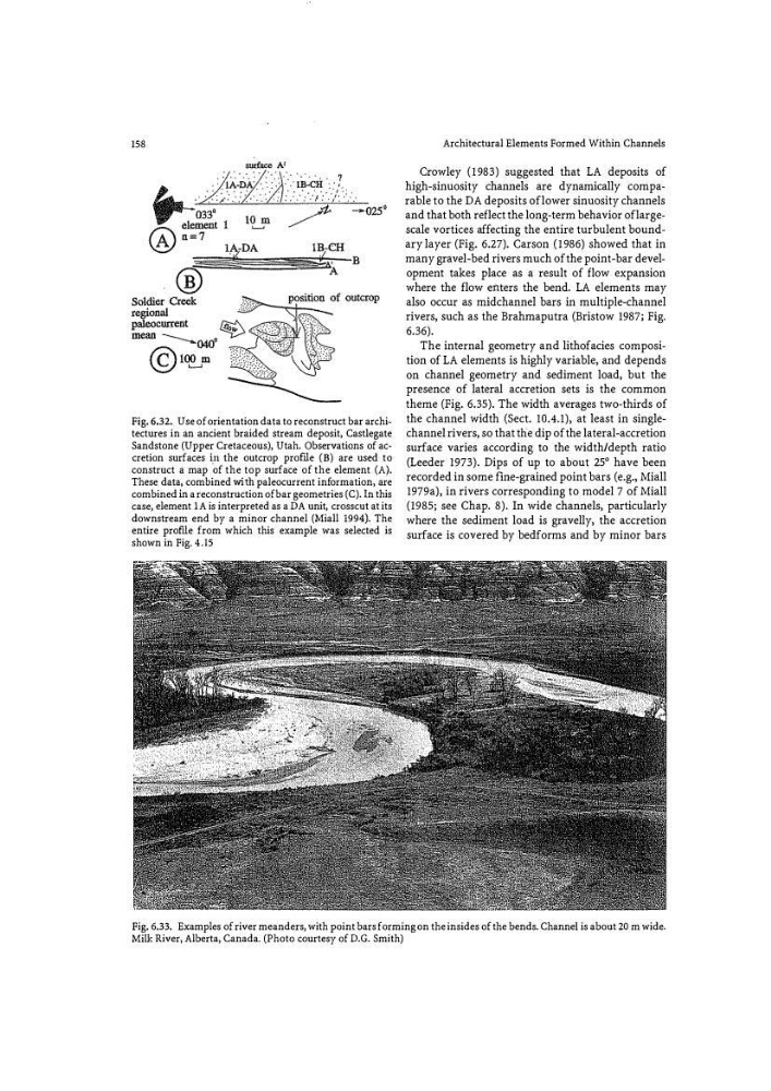
Fig. 6.33. Examples of river meanders, with point bars forming on the insides of the bends. Channel is about 20 m wide.
Milk River, Alberta, Canada. (Photo courtesy of D.G. Smith)
Fig. 6.32. Use of orientation data to reconstruct bar archi�
tectures in an ancient braided stream deposit, Castlegate
Sandstone (Upper Cretaceous), Utah. Observations of accretion surfaces ip. the outcrop prof.tle (B) are used to
construct a map of the top surface of the element (A).
These data, combined with paleocurrent information, are
combined in a reconstruction ofbar geometries (C). ln this
case, element lA is interpreted as aDA unit, crosscut at its
downstream end by a minor channel (Miall 1994). The
entire profile from which this example was selected is
shown in Fig. 4.15
Architectural Elements Formed Within Channels
Crowley (1983) suggested that LA deposits of
high-sinuosity channels are dynamically comparable to the DA deposits oflower sinuosity channels
and that both reflect the long-term behavior oflargescale vortices affecting the entire turbulent bound�
ary layer (Fig. 6.27). Carson (1986) showed that in
many gravel-bed rivers much of the point-bar development takes place as a result of flow expansion
where the flow enters the bend. LA elements may
also occur as midchannel bars in multiple-channel
rivers, such as the Brahmaputra (Bristow 1987; Fig.
6.36).
The internal geometry and lithofacies composi�
tion of LA elements is highly variable, and depends
on channel geometry and sediment load, but the
presence of lateral accretion sets is the common
theme (Fig. 6.35). The width averages two-thirds of
the channel width (Sect. 10.4.1), at least in singlechannel rivers, so that the dip of the lateral-accretion
surface varies according to the width/depth ratio
(Leeder 1973). Dips of up to about 25" have been
recorded in some fine-grained point bars (e.g., Miall
1979a), in rivers corresponding to model 7 of Miall
(1985; see Chap. 8). In wide channels, particularly
where the sediment load is gravelly, the accretion
surface is covered by bedforms and by minor bars
Fig. 6.33. Examples of river meanders, with point bars forming on the insides of the bends. Channel is about 20 m wide.
Milk River, Alberta, Canada. (Photo courtesy of D.G. Smith)