

94
P. J. Deshpande et al.
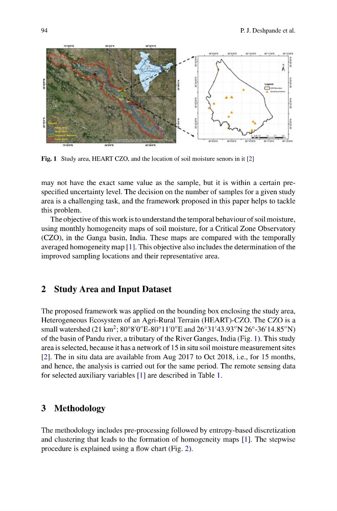
Fig. 1 Study area, HEART CZO, and the location of soil moisture senors in it [2]
may not have the exact same value as the sample, but it is within a certain prespecified uncertainty level. The decision on the number of samples for a given study
area is a challenging task, and the framework proposed in this paper helps to tackle
this problem.
The objective of this work is to understand the temporal behaviour of soil moisture,
using monthly homogeneity maps of soil moisture, for a Critical Zone Observatory
(CZO), in the Ganga basin, India. These maps are compared with the temporally
averaged homogeneity map [1]. This objective also includes the determination of the
improved sampling locations and their representative area.
2 Study Area and Input Dataset
The proposed framework was applied on the bounding box enclosing the study area,
Heterogeneous Ecosystem of an Agri-Rural Terrain (HEART)-CZO. The CZO is a
small watershed (21 km
2 ; 80°8
0
E-80°11
0
E and 26°31
43.93
N 26°-36
14.85
N)
of the basin of Pandu river, a tributary of the River Ganges, India (Fig. 1). This study
area is selected, because it has a network of 15 in situ soil moisture measurement sites
[2]. The in situ data are available from Aug 2017 to Oct 2018, i.e., for 15 months,
and hence, the analysis is carried out for the same period. The remote sensing data
for selected auxiliary variables [1] are described in Table 1.
3 Methodology
The methodology includes pre-processing followed by entropy-based discretization
and clustering that leads to the formation of homogeneity maps [1]. The stepwise
procedure is explained using a flow chart (Fig. 2).
P. J. Deshpande et al.
Fig. 1 Study area, HEART CZO, and the location of soil moisture senors in it [2]
may not have the exact same value as the sample, but it is within a certain prespecified uncertainty level. The decision on the number of samples for a given study
area is a challenging task, and the framework proposed in this paper helps to tackle
this problem.
The objective of this work is to understand the temporal behaviour of soil moisture,
using monthly homogeneity maps of soil moisture, for a Critical Zone Observatory
(CZO), in the Ganga basin, India. These maps are compared with the temporally
averaged homogeneity map [1]. This objective also includes the determination of the
improved sampling locations and their representative area.
2 Study Area and Input Dataset
The proposed framework was applied on the bounding box enclosing the study area,
Heterogeneous Ecosystem of an Agri-Rural Terrain (HEART)-CZO. The CZO is a
small watershed (21 km
2 ; 80°8
0
E-80°11
0
E and 26°31
43.93
N 26°-36
14.85
N)
of the basin of Pandu river, a tributary of the River Ganges, India (Fig. 1). This study
area is selected, because it has a network of 15 in situ soil moisture measurement sites
[2]. The in situ data are available from Aug 2017 to Oct 2018, i.e., for 15 months,
and hence, the analysis is carried out for the same period. The remote sensing data
for selected auxiliary variables [1] are described in Table 1.
3 Methodology
The methodology includes pre-processing followed by entropy-based discretization
and clustering that leads to the formation of homogeneity maps [1]. The stepwise
procedure is explained using a flow chart (Fig. 2).