

ice core drilling (mostly located on the Antarctic plateau (see
Chap. 10, Volume 1), marine drilling at the edges,
multi-beam sonar data at sea and marks of glaciations on the
rocks and mountains beyond the current cap (trimlines or the
limit between the glacial erosion model and the model of
erosion by atmospheric processes). Digital modeling of the
ice cores helps to connect the various data to explain the
mechanisms involved.
For the past 3 million years, Antarctica has oscillated
between two (or even three) states, with the East Antarctic
and West Antarctic ice sheets behaving differently (oppositely in terms of volume). Four processes govern this evolution: (i) the surface temperature has little immediate
influence. Indeed, since the maximum temperature on the
coasts is about −10 °C, ablation is not a significant mechanism except on ice shelves. In the long term, climate
temperature variations propagate through the ice and eventually reach the base of the glacier, where deformation and
sliding are concentrated. The flow is then intensified but it
takes about ten thousand years before this process is felt;
(ii) precipitation has an immediate effect: the more it snows,
the more the ice sheet grows. In general, precipitation is
deemed to be related to atmospheric temperature. Therefore,
it snows more during warmer periods because the air can
then hold more moisture and this is borne out (at least on the
Antarctic plateau) by ice core analysis; (iii) flow brings the
ice towards the coast, is sensitive to basal conditions and to
the thermomechanical coupling mentioned above, but the
main feature of Antarctica is the presence of ice shelves that
act as a buttress limiting the speed of the ice streams. If these
ice shelves disappear, the upstream glaciers will accelerate
leading to thinning of the ice sheet; (iv) the movements of
the grounding line govern the size of the ice sheet, and the
larger the sheet, the thicker it becomes. The grounding line is
sensitive to sea level (if this lowers, ice shelves are able to
ground) by a purely geometric effect. In addition, the flow of
ice streams and the shift in the grounding line are linked, as a
retreat occurs in association with an acceleration. For
example, a disintegration of the ice shelves through an
acceleration of the flow may force a retreat of the grounding
line. Conversely, a retreat of the grounding line reduces the
basal friction of the ice stream (because it begins to float)
and allows it to accelerate. It should be noted that the precipitation effect acts in opposition to the others and tends to
produce a smaller ice sheet during the glacial period.
In the interglacial period, conditions are roughly similar
to the current ones. Compared with the present, the glacial
period has lower temperatures, less precipitation, a lower sea
level, and a colder ocean which help to maintain the ice
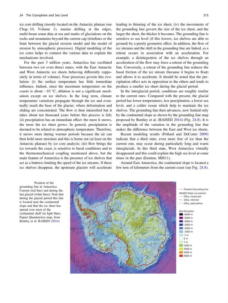
shelves. The grounding line then advances, now limited only
by the continental slope as shown by the grounding line map
proposed by Bentley et al. (RAISED 2014) (Fig. 24.8). It is
the amplitude of the variation in the grounding line that
makes the difference between the East and West ice sheets.
Recent modeling results (Pollard and DeConto 2009)
indicate that a third state, even more free of ice than the
current one, may occur during particularly long and warm
interglacials. In this third state, West Antarctica virtually
disappeared and this could explain the high sea level at some
times in the past (Eemien, MIS11).
Around East Antarctica, the continental slope is located a
few tens of kilometers from the current coast (see Fig. 24.8).
Fig. 24.8 Position of the
grounding line in Antarctica.
Current (red line) and during the
last glacial (white lines). Note that
during the glacial period this line
is located near the continental
slope and that the ice sheet has
spread over most of the
continental shelf (in light blue).
Figure Quantarctica map, from
Bentley et al. RAISED (2014)
24 The Cryosphere and Sea Level
315
Chap. 10, Volume 1), marine drilling at the edges,
multi-beam sonar data at sea and marks of glaciations on the
rocks and mountains beyond the current cap (trimlines or the
limit between the glacial erosion model and the model of
erosion by atmospheric processes). Digital modeling of the
ice cores helps to connect the various data to explain the
mechanisms involved.
For the past 3 million years, Antarctica has oscillated
between two (or even three) states, with the East Antarctic
and West Antarctic ice sheets behaving differently (oppositely in terms of volume). Four processes govern this evolution: (i) the surface temperature has little immediate
influence. Indeed, since the maximum temperature on the
coasts is about −10 °C, ablation is not a significant mechanism except on ice shelves. In the long term, climate
temperature variations propagate through the ice and eventually reach the base of the glacier, where deformation and
sliding are concentrated. The flow is then intensified but it
takes about ten thousand years before this process is felt;
(ii) precipitation has an immediate effect: the more it snows,
the more the ice sheet grows. In general, precipitation is
deemed to be related to atmospheric temperature. Therefore,
it snows more during warmer periods because the air can
then hold more moisture and this is borne out (at least on the
Antarctic plateau) by ice core analysis; (iii) flow brings the
ice towards the coast, is sensitive to basal conditions and to
the thermomechanical coupling mentioned above, but the
main feature of Antarctica is the presence of ice shelves that
act as a buttress limiting the speed of the ice streams. If these
ice shelves disappear, the upstream glaciers will accelerate
leading to thinning of the ice sheet; (iv) the movements of
the grounding line govern the size of the ice sheet, and the
larger the sheet, the thicker it becomes. The grounding line is
sensitive to sea level (if this lowers, ice shelves are able to
ground) by a purely geometric effect. In addition, the flow of
ice streams and the shift in the grounding line are linked, as a
retreat occurs in association with an acceleration. For
example, a disintegration of the ice shelves through an
acceleration of the flow may force a retreat of the grounding
line. Conversely, a retreat of the grounding line reduces the
basal friction of the ice stream (because it begins to float)
and allows it to accelerate. It should be noted that the precipitation effect acts in opposition to the others and tends to
produce a smaller ice sheet during the glacial period.
In the interglacial period, conditions are roughly similar
to the current ones. Compared with the present, the glacial
period has lower temperatures, less precipitation, a lower sea
level, and a colder ocean which help to maintain the ice
shelves. The grounding line then advances, now limited only
by the continental slope as shown by the grounding line map
proposed by Bentley et al. (RAISED 2014) (Fig. 24.8). It is
the amplitude of the variation in the grounding line that
makes the difference between the East and West ice sheets.
Recent modeling results (Pollard and DeConto 2009)
indicate that a third state, even more free of ice than the
current one, may occur during particularly long and warm
interglacials. In this third state, West Antarctica virtually
disappeared and this could explain the high sea level at some
times in the past (Eemien, MIS11).
Around East Antarctica, the continental slope is located a
few tens of kilometers from the current coast (see Fig. 24.8).
Fig. 24.8 Position of the
grounding line in Antarctica.
Current (red line) and during the
last glacial (white lines). Note that
during the glacial period this line
is located near the continental
slope and that the ice sheet has
spread over most of the
continental shelf (in light blue).
Figure Quantarctica map, from
Bentley et al. RAISED (2014)
24 The Cryosphere and Sea Level
315