

altitude-surface temperature feedback. This instability is
often referred to as the ‘instability of small ice sheets’;
– the Barents and Kara caps are ocean ice sheets whose
base is below sea level (as is the case for West Antarctica)
and this makes them sensitive to the instability of the
marine ice sheets, which is linked to the dynamics of the
ice flow. In addition, these ice sheets formed a glacial
barrier which retained huge lakes. These lakes tempered
the Siberian summers and reduced the melting of the
glacial ice sheets, another positive feedback, but occurring during the cold period unlike the previous two.
Another interesting point concerns the location of the ice
sheet during the glacial period. During the LGM, the
Fennoscandian ice sheet was similar in size as it was at
90 ka BP, but located further to the west. This phenomenon
is not explained but an interaction between the topography
of the ice sheets and atmospheric circulation is suspected.
For example, at the end of glaciation, the presence of the
Scandinavian sheet prevented the transport of moisture
towards the east.
The Fennoscandian ice sheet appears to have reached its
maximum extent to the south between 20 and 18 ka BP. The
deglaciation of the continental shelf began around 15 ka BP
and from 13 ka BP onwards the ice retreated northward to
the archipelagoes of the Arctic, while in the south, the
Scandinavian cap receded to the Gulf of Bothnia and the
Finnish border. After 10,000 years BP, the ice was confined
to the Norwegian mountains and at the climate optimum of
the Holocene, the ice cover was probably smaller than at
present.
Antarctica
There is much less information available on the evolution of
the Antarctic ice sheet partly because of the harsh conditions
(logistics, climate), partly because the variations were
smaller and partly because most traces of the Last Glacial
Maximum are to be found at sea. Information comes from
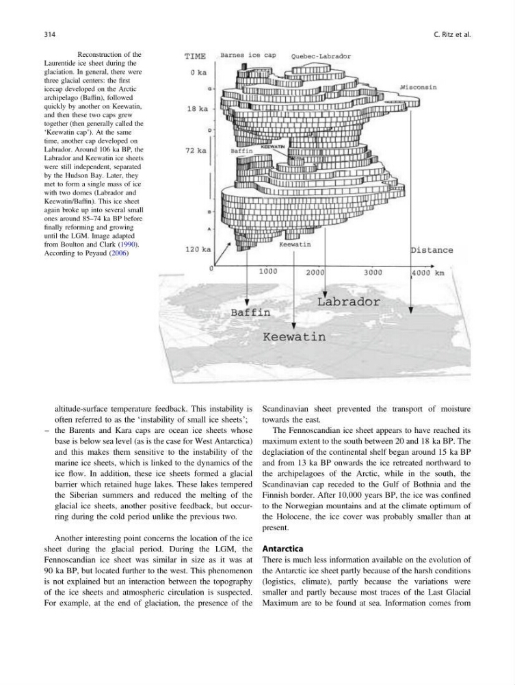
Fig. 24.7 Reconstruction of the
Laurentide ice sheet during the
glaciation. In general, there were
three glacial centers: the first
icecap developed on the Arctic
archipelago (Baffin), followed
quickly by another on Keewatin,
and then these two caps grew
together (then generally called the
‘Keewatin cap’). At the same
time, another cap developed on
Labrador. Around 106 ka BP, the
Labrador and Keewatin ice sheets
were still independent, separated
by the Hudson Bay. Later, they
met to form a single mass of ice
with two domes (Labrador and
Keewatin/Baffin). This ice sheet
again broke up into several small
ones around 85–74 ka BP before
finally reforming and growing
until the LGM. Image adapted
from Boulton and Clark (1990).
According to Peyaud (2006)
314
C. Ritz et al.
often referred to as the ‘instability of small ice sheets’;
– the Barents and Kara caps are ocean ice sheets whose
base is below sea level (as is the case for West Antarctica)
and this makes them sensitive to the instability of the
marine ice sheets, which is linked to the dynamics of the
ice flow. In addition, these ice sheets formed a glacial
barrier which retained huge lakes. These lakes tempered
the Siberian summers and reduced the melting of the
glacial ice sheets, another positive feedback, but occurring during the cold period unlike the previous two.
Another interesting point concerns the location of the ice
sheet during the glacial period. During the LGM, the
Fennoscandian ice sheet was similar in size as it was at
90 ka BP, but located further to the west. This phenomenon
is not explained but an interaction between the topography
of the ice sheets and atmospheric circulation is suspected.
For example, at the end of glaciation, the presence of the
Scandinavian sheet prevented the transport of moisture
towards the east.
The Fennoscandian ice sheet appears to have reached its
maximum extent to the south between 20 and 18 ka BP. The
deglaciation of the continental shelf began around 15 ka BP
and from 13 ka BP onwards the ice retreated northward to
the archipelagoes of the Arctic, while in the south, the
Scandinavian cap receded to the Gulf of Bothnia and the
Finnish border. After 10,000 years BP, the ice was confined
to the Norwegian mountains and at the climate optimum of
the Holocene, the ice cover was probably smaller than at
present.
Antarctica
There is much less information available on the evolution of
the Antarctic ice sheet partly because of the harsh conditions
(logistics, climate), partly because the variations were
smaller and partly because most traces of the Last Glacial
Maximum are to be found at sea. Information comes from
Fig. 24.7 Reconstruction of the
Laurentide ice sheet during the
glaciation. In general, there were
three glacial centers: the first
icecap developed on the Arctic
archipelago (Baffin), followed
quickly by another on Keewatin,
and then these two caps grew
together (then generally called the
‘Keewatin cap’). At the same
time, another cap developed on
Labrador. Around 106 ka BP, the
Labrador and Keewatin ice sheets
were still independent, separated
by the Hudson Bay. Later, they
met to form a single mass of ice
with two domes (Labrador and
Keewatin/Baffin). This ice sheet
again broke up into several small
ones around 85–74 ka BP before
finally reforming and growing
until the LGM. Image adapted
from Boulton and Clark (1990).
According to Peyaud (2006)
314
C. Ritz et al.