

When the ice from an ice sheet flows to the coast, it
begins to float on the sea, forming either tongues of ice or
ice-shelves. Currently, the largest of these are the Ross and
Ronne-Filchner ice shelves in Antarctica (see map on
Fig. 24.2). The line where the ice begins to float is called the
grounding line, and we will return to this point as it is
important for the evolution of an ice sheet.
The thickness of the ice shelves can reach 2000 m at the
grounding line, but they generally thin off rapidly as they
reach the ocean and are about 200 m thick at the front. At
the front, the ice shelves crack and break off, producing
icebergs (calving phenomenon). Ice-shelves and sea ice
should not be confused. The latter is made of seawater and,
although some of the salt is expelled during the freezing
process, they are still not composed of freshwater. Moreover,
sea ice is only about a few meters thick.
Finally, the edge of a sheet (terrestrial or marine) is
generally not uniform, but rather an alternation of
fast-moving glaciers and relatively immobile zones. These
fast-moving glaciers are called outlet glaciers. Their location
depends on the topography of the bedrock (their flow is
channeled into sub-glacial valleys) and on its geological
properties with zones with relatively rapid flow (several
hundred meters a year) being observed in the midst of relatively stagnant ice (a few meters per year). In Antarctica,
some of these glaciers begin several hundred kilometers
inside the ice sheet. When they are particularly wide
(*40 km), they are also called ice streams.
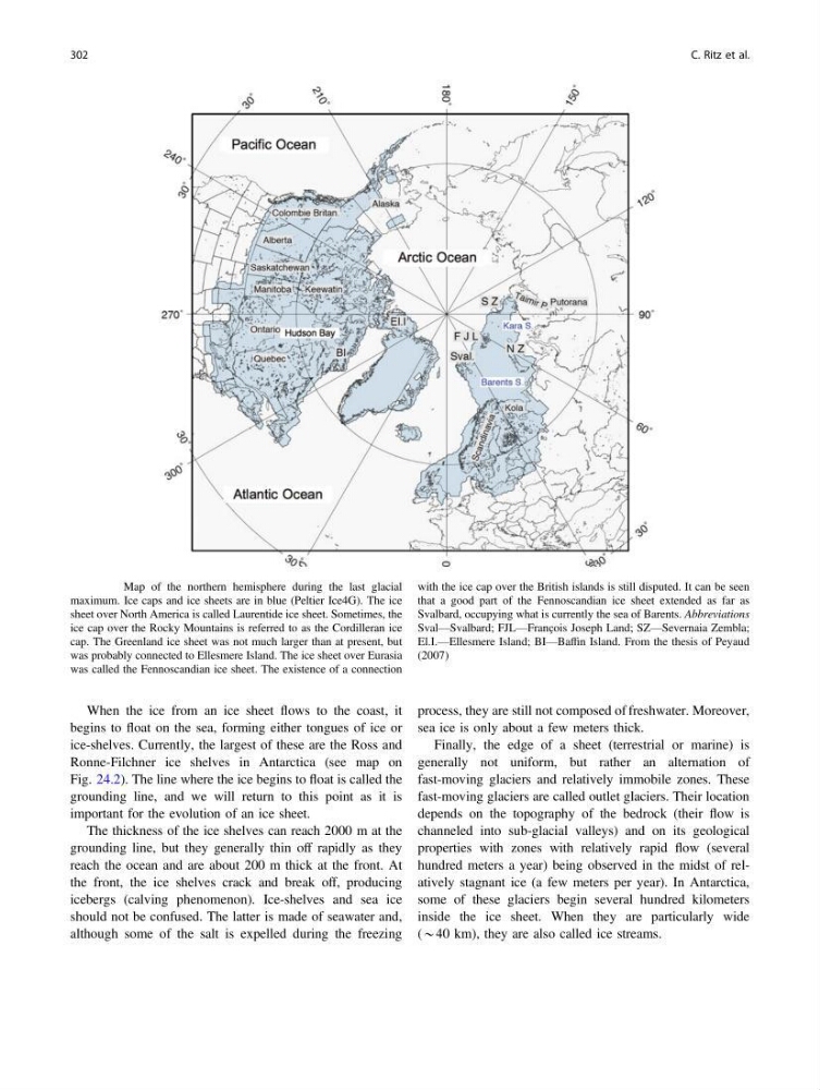
Fig. 24.1 Map of the northern hemisphere during the last glacial
maximum. Ice caps and ice sheets are in blue (Peltier Ice4G). The ice
sheet over North America is called Laurentide ice sheet. Sometimes, the
ice cap over the Rocky Mountains is referred to as the Cordilleran ice
cap. The Greenland ice sheet was not much larger than at present, but
was probably connected to Ellesmere Island. The ice sheet over Eurasia
was called the Fennoscandian ice sheet. The existence of a connection
with the ice cap over the British islands is still disputed. It can be seen
that a good part of the Fennoscandian ice sheet extended as far as
Svalbard, occupying what is currently the sea of Barents. Abbreviations
Sval—Svalbard; FJL—François Joseph Land; SZ—Severnaia Zembla;
El.I.—Ellesmere Island; BI—Baffin Island. From the thesis of Peyaud
(2007)
302
C. Ritz et al.
begins to float on the sea, forming either tongues of ice or
ice-shelves. Currently, the largest of these are the Ross and
Ronne-Filchner ice shelves in Antarctica (see map on
Fig. 24.2). The line where the ice begins to float is called the
grounding line, and we will return to this point as it is
important for the evolution of an ice sheet.
The thickness of the ice shelves can reach 2000 m at the
grounding line, but they generally thin off rapidly as they
reach the ocean and are about 200 m thick at the front. At
the front, the ice shelves crack and break off, producing
icebergs (calving phenomenon). Ice-shelves and sea ice
should not be confused. The latter is made of seawater and,
although some of the salt is expelled during the freezing
process, they are still not composed of freshwater. Moreover,
sea ice is only about a few meters thick.
Finally, the edge of a sheet (terrestrial or marine) is
generally not uniform, but rather an alternation of
fast-moving glaciers and relatively immobile zones. These
fast-moving glaciers are called outlet glaciers. Their location
depends on the topography of the bedrock (their flow is
channeled into sub-glacial valleys) and on its geological
properties with zones with relatively rapid flow (several
hundred meters a year) being observed in the midst of relatively stagnant ice (a few meters per year). In Antarctica,
some of these glaciers begin several hundred kilometers
inside the ice sheet. When they are particularly wide
(*40 km), they are also called ice streams.
Fig. 24.1 Map of the northern hemisphere during the last glacial
maximum. Ice caps and ice sheets are in blue (Peltier Ice4G). The ice
sheet over North America is called Laurentide ice sheet. Sometimes, the
ice cap over the Rocky Mountains is referred to as the Cordilleran ice
cap. The Greenland ice sheet was not much larger than at present, but
was probably connected to Ellesmere Island. The ice sheet over Eurasia
was called the Fennoscandian ice sheet. The existence of a connection
with the ice cap over the British islands is still disputed. It can be seen
that a good part of the Fennoscandian ice sheet extended as far as
Svalbard, occupying what is currently the sea of Barents. Abbreviations
Sval—Svalbard; FJL—François Joseph Land; SZ—Severnaia Zembla;
El.I.—Ellesmere Island; BI—Baffin Island. From the thesis of Peyaud
(2007)
302
C. Ritz et al.