

15.1 The First 100 Min
169
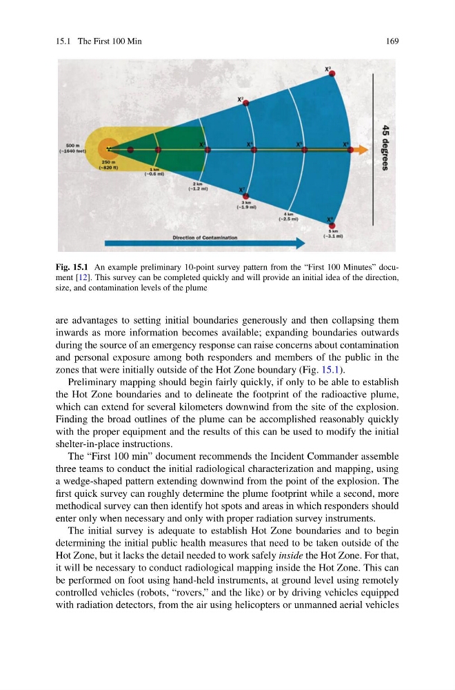
Fig. 15.1 An example preliminary 10-point survey pattern from the “First 100 Minutes” document [12]. This survey can be completed quickly and will provide an initial idea of the direction,
size, and contamination levels of the plume
are advantages to setting initial boundaries generously and then collapsing them
inwards as more information becomes available; expanding boundaries outwards
during the source of an emergency response can raise concerns about contamination
and personal exposure among both responders and members of the public in the
zones that were initially outside of the Hot Zone boundary (Fig. 15.1).
Preliminary mapping should begin fairly quickly, if only to be able to establish
the Hot Zone boundaries and to delineate the footprint of the radioactive plume,
which can extend for several kilometers downwind from the site of the explosion.
Finding the broad outlines of the plume can be accomplished reasonably quickly
with the proper equipment and the results of this can be used to modify the initial
shelter-in-place instructions.
The “First 100 min” document recommends the Incident Commander assemble
three teams to conduct the initial radiological characterization and mapping, using
a wedge-shaped pattern extending downwind from the point of the explosion. The
first quick survey can roughly determine the plume footprint while a second, more
methodical survey can then identify hot spots and areas in which responders should
enter only when necessary and only with proper radiation survey instruments.
The initial survey is adequate to establish Hot Zone boundaries and to begin
determining the initial public health measures that need to be taken outside of the
Hot Zone, but it lacks the detail needed to work safely inside the Hot Zone. For that,
it will be necessary to conduct radiological mapping inside the Hot Zone. This can
be performed on foot using hand-held instruments, at ground level using remotely
controlled vehicles (robots, “rovers,” and the like) or by driving vehicles equipped
with radiation detectors, from the air using helicopters or unmanned aerial vehicles
169
Fig. 15.1 An example preliminary 10-point survey pattern from the “First 100 Minutes” document [12]. This survey can be completed quickly and will provide an initial idea of the direction,
size, and contamination levels of the plume
are advantages to setting initial boundaries generously and then collapsing them
inwards as more information becomes available; expanding boundaries outwards
during the source of an emergency response can raise concerns about contamination
and personal exposure among both responders and members of the public in the
zones that were initially outside of the Hot Zone boundary (Fig. 15.1).
Preliminary mapping should begin fairly quickly, if only to be able to establish
the Hot Zone boundaries and to delineate the footprint of the radioactive plume,
which can extend for several kilometers downwind from the site of the explosion.
Finding the broad outlines of the plume can be accomplished reasonably quickly
with the proper equipment and the results of this can be used to modify the initial
shelter-in-place instructions.
The “First 100 min” document recommends the Incident Commander assemble
three teams to conduct the initial radiological characterization and mapping, using
a wedge-shaped pattern extending downwind from the point of the explosion. The
first quick survey can roughly determine the plume footprint while a second, more
methodical survey can then identify hot spots and areas in which responders should
enter only when necessary and only with proper radiation survey instruments.
The initial survey is adequate to establish Hot Zone boundaries and to begin
determining the initial public health measures that need to be taken outside of the
Hot Zone, but it lacks the detail needed to work safely inside the Hot Zone. For that,
it will be necessary to conduct radiological mapping inside the Hot Zone. This can
be performed on foot using hand-held instruments, at ground level using remotely
controlled vehicles (robots, “rovers,” and the like) or by driving vehicles equipped
with radiation detectors, from the air using helicopters or unmanned aerial vehicles