

Non-transitory uses include:
• Commercial fishing (traps/pots, weirs)
• Navigation channels
• Deepwater ports
• Wind farms
• Aquaculture sites
• Ocean dumping sites
• Shipwrecks
• Pipelines
• Marine protected areas
• Aesthetic viewsheds
The characteristics of a given area of ocean space make it more or less valuable
to different uses. For example, the characteristics that determine the value of an area
of ocean for marine aquaculture include distance from shore facilities (ports),
nutrient fluxes, plankton densities, water temperature ranges, wind and wave conditions, current flows and flushing rates, prevalence of predators and parasites,
marine contaminants, etc.
Because ocean space is of varying quality in this sense, it will produce a gradient
of (potential) resource rents from alternative uses. At the same time, those uses may
result in external effects if resources are degraded due to pollution, for example, or
if opportunity costs arise due to forgone other uses of the space.
Historically, ocean space has not been allocated through private markets, but has
instead been assigned to competing uses by pre-existing policies, implied legal
8°30'0"E
8°30'0"E
8°0'0"E
8°0'0"E
7°30'0"E
7°30'0"E
7°0'0"E
7°0'0"E
6°30'0"E
6°30'0"E
6°0'0"E
6°0'0"E
5°30'0"E
5°30'0"E
5°0'0"E
5°0'0"E
4°30'0"E
4°30'0"E
4°0'0"E
4°0'0"E
3°30'0"E
3°30'0"E
55°30'0"N
55°30'0"N
55°0'0"N
55°0'0"N
54°30'0"N
54°30'0"N
54°0'0"N
54°0'0"N
Detail A
Detail B
Regulations
Shipping
Priority Area Shipping
Reservation Area Shipping
Pipelines
Priority Area Pipelines
Reservation Area Pipelines
Submarine Cables
Gate
Research
Reservation Area Research
Energy
Priority Areas for Offshore Wind Energy
6° 36' 00,33" E / 54°12' 39,02" N
6° 35' 23,83" E / 54° 12' 38,57" N
6° 42' 57,16" E / 54° 07' 44,12" N
Detail A
6° 55' 50,17" E / 53° 56' 22,61" N
6° 56' 55,14" E / 53° 56' 31,84" N
8° 00° 56,64" E / 54° 22' 59,90" N
8° 01' 18,60" E / 54° 23' 06,72" N
8° 01' 45,79" E / 54° 22' 50,85" N
Detail C
For Information Only
Shipping
Traffic Separation Scheme
Precautionary Area
Deep Water Road
Anchoring Area
Exploitation of Natural Resources
Sand / Gravel - Plan approved
Sand / Gravel - Project in Approval Procedure
Sand / Gravel - Licence
Natural Gas - Licence
Pipelines
Natural Gas (in use)
Submarine Cables
High Voltage Cable (in use)
High Voltage Cable (approved)
Data Cable (in use)
Data Cable (out of use)
Energy
Offshore Wind Farms approved by 14.08.2009
Reference Area Offshore Wind Energy
Nature Conservation
Natura 2000 - SCI Habitat Directive
Natura 2000 - SPA Bird Directive
Military Use
Military Exercise Area
Miscellaneous
Previous Ammunition Area
Measurement / Converter Platform
Boundaries
Continental Shelf/EEZ
Territorial Sea/12 nm Zone
International Border
Planning Area
Boundaries of Planning Area
0
1 0
2 0
3 0
40
5
km
Norden
NORDERNEY
Wilhelmshaven
Bremerhaven
3.1
3.3
3.3
3.4
3.5
3.2
(Details A - C)
6° 59' 17,8'' E / 53° 53' 29,1'' N
6° 58' 17,3'' E / 53° 53' 13,1'' N
6° 43' 33,55" E / 54° 07' 44,56" N
Jade
Elbe
BORKUM
3.5
3.3
3.3
4.1
3.1
4.4
Denmark
Text-Nr.
3.7
Spatial Plan for the German Exclusive
Economic Zone of the North Sea
- Map -
Map projection:
Mercator (54° N), WGS 84
Federal Maritime and Hydrographic Agency
Hamburg and Rostock
Scale 1:400.000
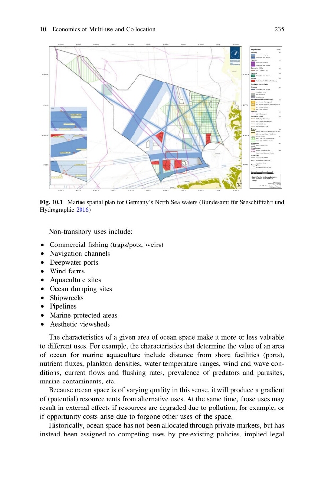
Fig. 10.1 Marine spatial plan for Germany’s North Sea waters (Bundesamt für Seeschifffahrt und
Hydrographie 2016)
10 Economics of Multi-use and Co-location
235
• Commercial fishing (traps/pots, weirs)
• Navigation channels
• Deepwater ports
• Wind farms
• Aquaculture sites
• Ocean dumping sites
• Shipwrecks
• Pipelines
• Marine protected areas
• Aesthetic viewsheds
The characteristics of a given area of ocean space make it more or less valuable
to different uses. For example, the characteristics that determine the value of an area
of ocean for marine aquaculture include distance from shore facilities (ports),
nutrient fluxes, plankton densities, water temperature ranges, wind and wave conditions, current flows and flushing rates, prevalence of predators and parasites,
marine contaminants, etc.
Because ocean space is of varying quality in this sense, it will produce a gradient
of (potential) resource rents from alternative uses. At the same time, those uses may
result in external effects if resources are degraded due to pollution, for example, or
if opportunity costs arise due to forgone other uses of the space.
Historically, ocean space has not been allocated through private markets, but has
instead been assigned to competing uses by pre-existing policies, implied legal
8°30'0"E
8°30'0"E
8°0'0"E
8°0'0"E
7°30'0"E
7°30'0"E
7°0'0"E
7°0'0"E
6°30'0"E
6°30'0"E
6°0'0"E
6°0'0"E
5°30'0"E
5°30'0"E
5°0'0"E
5°0'0"E
4°30'0"E
4°30'0"E
4°0'0"E
4°0'0"E
3°30'0"E
3°30'0"E
55°30'0"N
55°30'0"N
55°0'0"N
55°0'0"N
54°30'0"N
54°30'0"N
54°0'0"N
54°0'0"N
Detail A
Detail B
Regulations
Shipping
Priority Area Shipping
Reservation Area Shipping
Pipelines
Priority Area Pipelines
Reservation Area Pipelines
Submarine Cables
Gate
Research
Reservation Area Research
Energy
Priority Areas for Offshore Wind Energy
6° 36' 00,33" E / 54°12' 39,02" N
6° 35' 23,83" E / 54° 12' 38,57" N
6° 42' 57,16" E / 54° 07' 44,12" N
Detail A
6° 55' 50,17" E / 53° 56' 22,61" N
6° 56' 55,14" E / 53° 56' 31,84" N
8° 00° 56,64" E / 54° 22' 59,90" N
8° 01' 18,60" E / 54° 23' 06,72" N
8° 01' 45,79" E / 54° 22' 50,85" N
Detail C
For Information Only
Shipping
Traffic Separation Scheme
Precautionary Area
Deep Water Road
Anchoring Area
Exploitation of Natural Resources
Sand / Gravel - Plan approved
Sand / Gravel - Project in Approval Procedure
Sand / Gravel - Licence
Natural Gas - Licence
Pipelines
Natural Gas (in use)
Submarine Cables
High Voltage Cable (in use)
High Voltage Cable (approved)
Data Cable (in use)
Data Cable (out of use)
Energy
Offshore Wind Farms approved by 14.08.2009
Reference Area Offshore Wind Energy
Nature Conservation
Natura 2000 - SCI Habitat Directive
Natura 2000 - SPA Bird Directive
Military Use
Military Exercise Area
Miscellaneous
Previous Ammunition Area
Measurement / Converter Platform
Boundaries
Continental Shelf/EEZ
Territorial Sea/12 nm Zone
International Border
Planning Area
Boundaries of Planning Area
0
1 0
2 0
3 0
40
5
km
Norden
NORDERNEY
Wilhelmshaven
Bremerhaven
3.1
3.3
3.3
3.4
3.5
3.2
(Details A - C)
6° 59' 17,8'' E / 53° 53' 29,1'' N
6° 58' 17,3'' E / 53° 53' 13,1'' N
6° 43' 33,55" E / 54° 07' 44,56" N
Jade
Elbe
BORKUM
3.5
3.3
3.3
4.1
3.1
4.4
Denmark
Text-Nr.
3.7
Spatial Plan for the German Exclusive
Economic Zone of the North Sea
- Map -
Map projection:
Mercator (54° N), WGS 84
Federal Maritime and Hydrographic Agency
Hamburg and Rostock
Scale 1:400.000
Fig. 10.1 Marine spatial plan for Germany’s North Sea waters (Bundesamt für Seeschifffahrt und
Hydrographie 2016)
10 Economics of Multi-use and Co-location
235