

5.4 The Alboran Basin
The Alboran Sea is about 350 km long and 150 km wide, exhibiting a complex
seafloor physiography with several ridges and seamounts (Chap. 6). It currently
hosts three main sub-basins named after their respective geographic locations: the
Western Alboran Basin (hereafter WAB), Eastern Alboran Basin (EAB), and Southern Alboran Basin (SAB). The basins are separated at seafloor by morphostructural
features (Fig. 5.4).
5.4.1 Input from Potential Field Data
Gravity and magnetic data constitute what is known as “potential fields” and provide
information about the deep structure of a basin. In this case, Bouguer gravity
anomalies (Fig. 5.7) were obtained from a global free air dataset (Sandwell et al.
2014) with a resolution of 1 nautical mile. Magnetic anomalies correspond to the
second version of the World Digital Magnetic Anomaly Map Project at sea level,
which has a resolution of 3 nautical miles (Catalán et al. 2016) (Fig. 5.8). The
Analytic Signal (AS) of the magnetic field anomaly is a mathematical expression that
highlights the location of magnetic contacts (Roest et al. 1992; Roest and Pilkington
1993; Salem et al. 2002).
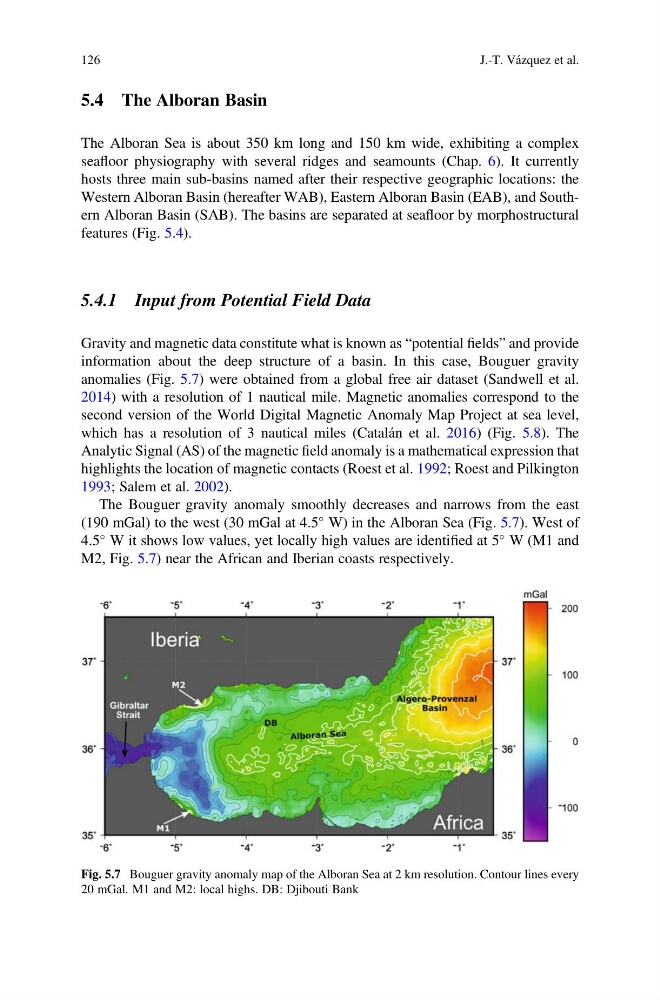
The Bouguer gravity anomaly smoothly decreases and narrows from the east
(190 mGal) to the west (30 mGal at 4.5
W) in the Alboran Sea (Fig. 5.7). West of
4.5
W it shows low values, yet locally high values are identified at 5
W (M1 and
M2, Fig. 5.7) near the African and Iberian coasts respectively.
Fig. 5.7 Bouguer gravity anomaly map of the Alboran Sea at 2 km resolution. Contour lines every
20 mGal. M1 and M2: local highs. DB: Djibouti Bank
126
J.-T. Vázquez et al.
The Alboran Sea is about 350 km long and 150 km wide, exhibiting a complex
seafloor physiography with several ridges and seamounts (Chap. 6). It currently
hosts three main sub-basins named after their respective geographic locations: the
Western Alboran Basin (hereafter WAB), Eastern Alboran Basin (EAB), and Southern Alboran Basin (SAB). The basins are separated at seafloor by morphostructural
features (Fig. 5.4).
5.4.1 Input from Potential Field Data
Gravity and magnetic data constitute what is known as “potential fields” and provide
information about the deep structure of a basin. In this case, Bouguer gravity
anomalies (Fig. 5.7) were obtained from a global free air dataset (Sandwell et al.
2014) with a resolution of 1 nautical mile. Magnetic anomalies correspond to the
second version of the World Digital Magnetic Anomaly Map Project at sea level,
which has a resolution of 3 nautical miles (Catalán et al. 2016) (Fig. 5.8). The
Analytic Signal (AS) of the magnetic field anomaly is a mathematical expression that
highlights the location of magnetic contacts (Roest et al. 1992; Roest and Pilkington
1993; Salem et al. 2002).
The Bouguer gravity anomaly smoothly decreases and narrows from the east
(190 mGal) to the west (30 mGal at 4.5
W) in the Alboran Sea (Fig. 5.7). West of
4.5
W it shows low values, yet locally high values are identified at 5
W (M1 and
M2, Fig. 5.7) near the African and Iberian coasts respectively.
Fig. 5.7 Bouguer gravity anomaly map of the Alboran Sea at 2 km resolution. Contour lines every
20 mGal. M1 and M2: local highs. DB: Djibouti Bank
126
J.-T. Vázquez et al.