

124
S. Sahai et al.
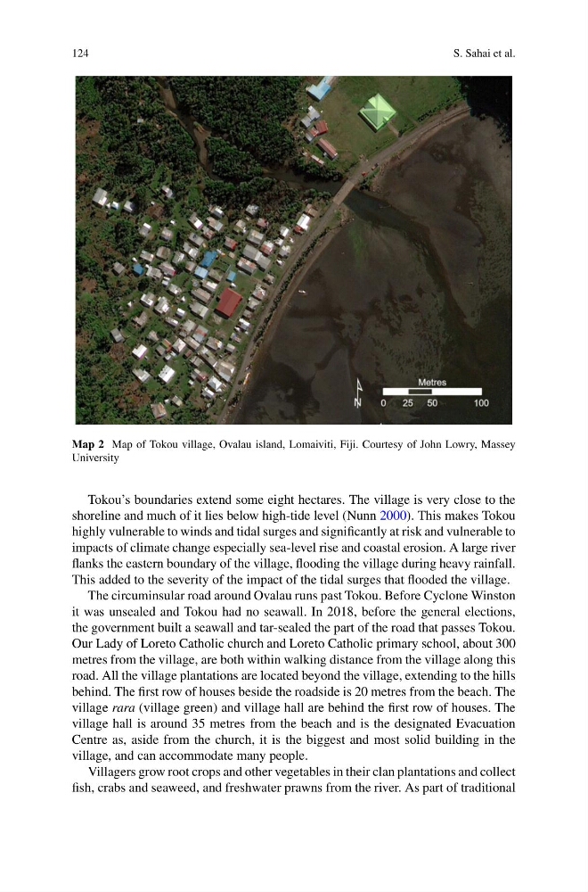
Map 2 Map of Tokou village, Ovalau island, Lomaiviti, Fiji. Courtesy of John Lowry, Massey
University
Tokou’s boundaries extend some eight hectares. The village is very close to the
shoreline and much of it lies below high-tide level (Nunn 2000). This makes Tokou
highly vulnerable to winds and tidal surges and significantly at risk and vulnerable to
impacts of climate change especially sea-level rise and coastal erosion. A large river
flanks the eastern boundary of the village, flooding the village during heavy rainfall.
This added to the severity of the impact of the tidal surges that flooded the village.
The circuminsular road around Ovalau runs past Tokou. Before Cyclone Winston
it was unsealed and Tokou had no seawall. In 2018, before the general elections,
the government built a seawall and tar-sealed the part of the road that passes Tokou.
Our Lady of Loreto Catholic church and Loreto Catholic primary school, about 300
metres from the village, are both within walking distance from the village along this
road. All the village plantations are located beyond the village, extending to the hills
behind. The first row of houses beside the roadside is 20 metres from the beach. The
village rara (village green) and village hall are behind the first row of houses. The
village hall is around 35 metres from the beach and is the designated Evacuation
Centre as, aside from the church, it is the biggest and most solid building in the
village, and can accommodate many people.
Villagers grow root crops and other vegetables in their clan plantations and collect
fish, crabs and seaweed, and freshwater prawns from the river. As part of traditional
S. Sahai et al.
Map 2 Map of Tokou village, Ovalau island, Lomaiviti, Fiji. Courtesy of John Lowry, Massey
University
Tokou’s boundaries extend some eight hectares. The village is very close to the
shoreline and much of it lies below high-tide level (Nunn 2000). This makes Tokou
highly vulnerable to winds and tidal surges and significantly at risk and vulnerable to
impacts of climate change especially sea-level rise and coastal erosion. A large river
flanks the eastern boundary of the village, flooding the village during heavy rainfall.
This added to the severity of the impact of the tidal surges that flooded the village.
The circuminsular road around Ovalau runs past Tokou. Before Cyclone Winston
it was unsealed and Tokou had no seawall. In 2018, before the general elections,
the government built a seawall and tar-sealed the part of the road that passes Tokou.
Our Lady of Loreto Catholic church and Loreto Catholic primary school, about 300
metres from the village, are both within walking distance from the village along this
road. All the village plantations are located beyond the village, extending to the hills
behind. The first row of houses beside the roadside is 20 metres from the beach. The
village rara (village green) and village hall are behind the first row of houses. The
village hall is around 35 metres from the beach and is the designated Evacuation
Centre as, aside from the church, it is the biggest and most solid building in the
village, and can accommodate many people.
Villagers grow root crops and other vegetables in their clan plantations and collect
fish, crabs and seaweed, and freshwater prawns from the river. As part of traditional