

if the chosen error distribution model is wrong (i.e. flow uncertainty bands become
too wide or too narrow), it can lead to false conclusions regarding the adequacy of
the input datasets, the hydrological model, and its parameters. Furthermore, understanding the uncertainty features of remotely sensed soil moisture is also useful in
controlling and correcting the soil moisture status in a hydrological model after
dry periods, so that error accumulation impact can be reduced. Therefore, error
distribution modelling of satellite soil moisture measurements is vital to the data
application in the hydrological community.
A study by [11] has attempted for the first time in modelling satellite soil moisture
error distribution in hydrological applications. It uses the SMOS soil moisture
product [58] and a hydrological model called Xinanjiang (XAJ) [100] as a case
study. In this study four commonly used probability distributions (Gaussian, extreme
value (EV), general extreme value (GEV), and logistic) are adopted to describe the
uncertainties of satellite soil moisture data, which are extensively evaluated by
using the chi-square statistical test and the bootstrapping resampling technique.
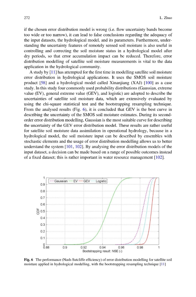
From the analysed results (Fig. 6), it is concluded that GEV is the best curve in
describing the uncertainty of the SMOS soil moisture estimates. During its secondorder error distribution modelling, Gaussian is the most suitable curve for describing
the uncertainty of the GEV error distribution model. These results are rather useful
for satellite soil moisture data assimilation in operational hydrology, because in a
hydrological model, the soil moisture input can be described by ensembles with
stochastic elements and the usage of error distribution modelling allows us to better
understand the system [101, 102]. By analysing the error distribution models of the
input dataset, a decision can be made based on a range of possible outcomes instead
of a fixed dataset; this is rather important in water resource management [102].
Fig. 6 The performance (Nash-Sutcliffe efficiency) of error distribution modelling for satellite soil
moisture applied in hydrological modelling, with the bootstrapping resampling technique [11]
272
L. Zhuo
too wide or too narrow), it can lead to false conclusions regarding the adequacy of
the input datasets, the hydrological model, and its parameters. Furthermore, understanding the uncertainty features of remotely sensed soil moisture is also useful in
controlling and correcting the soil moisture status in a hydrological model after
dry periods, so that error accumulation impact can be reduced. Therefore, error
distribution modelling of satellite soil moisture measurements is vital to the data
application in the hydrological community.
A study by [11] has attempted for the first time in modelling satellite soil moisture
error distribution in hydrological applications. It uses the SMOS soil moisture
product [58] and a hydrological model called Xinanjiang (XAJ) [100] as a case
study. In this study four commonly used probability distributions (Gaussian, extreme
value (EV), general extreme value (GEV), and logistic) are adopted to describe the
uncertainties of satellite soil moisture data, which are extensively evaluated by
using the chi-square statistical test and the bootstrapping resampling technique.
From the analysed results (Fig. 6), it is concluded that GEV is the best curve in
describing the uncertainty of the SMOS soil moisture estimates. During its secondorder error distribution modelling, Gaussian is the most suitable curve for describing
the uncertainty of the GEV error distribution model. These results are rather useful
for satellite soil moisture data assimilation in operational hydrology, because in a
hydrological model, the soil moisture input can be described by ensembles with
stochastic elements and the usage of error distribution modelling allows us to better
understand the system [101, 102]. By analysing the error distribution models of the
input dataset, a decision can be made based on a range of possible outcomes instead
of a fixed dataset; this is rather important in water resource management [102].
Fig. 6 The performance (Nash-Sutcliffe efficiency) of error distribution modelling for satellite soil
moisture applied in hydrological modelling, with the bootstrapping resampling technique [11]
272
L. Zhuo