

surface is scanned a number of times at various incidence angles, depending on the
location with respect to the satellite subtrack: the further away, the fewer the angular
acquisitions [72]. SMOS offers a global coverage at the equator crossing the times
of 6 a.m. (ascending) and 6 p.m. (descending), both at the local solar time [75].
SMAP is one of the first Earth observation satellites developed by the National
Aeronautics and Space Administration (NASA). It is able to monitor global soil
moisture at the land surface, as well as distinguish freeze/thaw land surface state.
In SMAP, a 40
constant incidence angle is adopted which enables the satellite
to scan the whole Earth in 2–3 days with ascending and descending overpasses
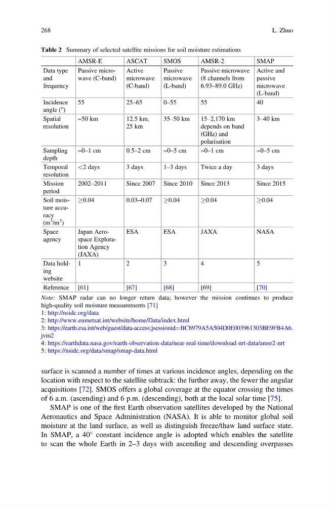
Table 2 Summary of selected satellite missions for soil moisture estimations
AMSR-E
ASCAT
SMOS
AMSR-2
SMAP
Data type
and
frequency
Passive microwave (C-band)
Active
microwave
(C-band)
Passive
microwave
(L-band)
Passive microwave
(8 channels from
6.93–89.0 GHz)
Active and
passive
microwave
(L-band)
Incidence
angle (
o
)
55
25–65
0–55
55
40
Spatial
resolution
~50 km
12.5 km,
25 km
35–50 km
15–2,170 km
depends on band
(GHz) and
polarisation
3–40 km
Sampling
depth
~0–1 cm
0.5–2 cm
~0–5 cm
~0–1 cm
~0–5 cm
Temporal
resolution
<2 days
3 days
1–3 days
Twice a day
3 days
Mission
period
2002–2011
Since 2007 Since 2010 Since 2013
Since 2015
Soil moisture accuracy
(m
3
/m
3
)
0.04
0.03–0.07
0.04
0.04
0.04
Space
agency
Japan Aerospace Exploration Agency
(JAXA)
ESA
ESA
JAXA
NASA
Data holding
website
1
2
3
4
5
Reference [61]
[ 67]
[ 68]
[ 69]
[ 70]
Note: SMAP radar can no longer return data; however the mission continues to produce
high-quality soil moisture measurements [71]
1: http://nsidc.org/data
2: http://www.eumetsat.int/website/home/Data/index.html
3: https://earth.esa.int/web/guest/data-access;jsessionid¼BC8979A5A504D0E003961303BE9FB4A6.
jvm2
4: https://earthdata.nasa.gov/earth-observation-data/near-real-time/download-nrt-data/amsr2-nrt
5: https://nsidc.org/data/smap/smap-data.html
268
L. Zhuo
location with respect to the satellite subtrack: the further away, the fewer the angular
acquisitions [72]. SMOS offers a global coverage at the equator crossing the times
of 6 a.m. (ascending) and 6 p.m. (descending), both at the local solar time [75].
SMAP is one of the first Earth observation satellites developed by the National
Aeronautics and Space Administration (NASA). It is able to monitor global soil
moisture at the land surface, as well as distinguish freeze/thaw land surface state.
In SMAP, a 40
constant incidence angle is adopted which enables the satellite
to scan the whole Earth in 2–3 days with ascending and descending overpasses
Table 2 Summary of selected satellite missions for soil moisture estimations
AMSR-E
ASCAT
SMOS
AMSR-2
SMAP
Data type
and
frequency
Passive microwave (C-band)
Active
microwave
(C-band)
Passive
microwave
(L-band)
Passive microwave
(8 channels from
6.93–89.0 GHz)
Active and
passive
microwave
(L-band)
Incidence
angle (
o
)
55
25–65
0–55
55
40
Spatial
resolution
~50 km
12.5 km,
25 km
35–50 km
15–2,170 km
depends on band
(GHz) and
polarisation
3–40 km
Sampling
depth
~0–1 cm
0.5–2 cm
~0–5 cm
~0–1 cm
~0–5 cm
Temporal
resolution
<2 days
3 days
1–3 days
Twice a day
3 days
Mission
period
2002–2011
Since 2007 Since 2010 Since 2013
Since 2015
Soil moisture accuracy
(m
3
/m
3
)
0.04
0.03–0.07
0.04
0.04
0.04
Space
agency
Japan Aerospace Exploration Agency
(JAXA)
ESA
ESA
JAXA
NASA
Data holding
website
1
2
3
4
5
Reference [61]
[ 67]
[ 68]
[ 69]
[ 70]
Note: SMAP radar can no longer return data; however the mission continues to produce
high-quality soil moisture measurements [71]
1: http://nsidc.org/data
2: http://www.eumetsat.int/website/home/Data/index.html
3: https://earth.esa.int/web/guest/data-access;jsessionid¼BC8979A5A504D0E003961303BE9FB4A6.
jvm2
4: https://earthdata.nasa.gov/earth-observation-data/near-real-time/download-nrt-data/amsr2-nrt
5: https://nsidc.org/data/smap/smap-data.html
268
L. Zhuo