

2.4 Variations in the Vertical Profile of Reflectivity
Microphysics determines the hydrometeors present in the atmosphere by affecting
their growth or evaporation and thermodynamic phase, which in turn shapes the
structure of the reflectivity with height [1]. This is known as the vertical profile of
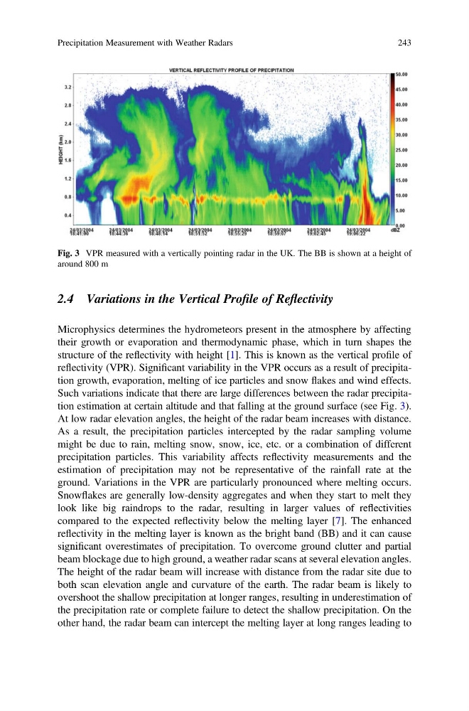
reflectivity (VPR). Significant variability in the VPR occurs as a result of precipitation growth, evaporation, melting of ice particles and snow flakes and wind effects.
Such variations indicate that there are large differences between the radar precipitation estimation at certain altitude and that falling at the ground surface (see Fig. 3).
At low radar elevation angles, the height of the radar beam increases with distance.
As a result, the precipitation particles intercepted by the radar sampling volume
might be due to rain, melting snow, snow, ice, etc. or a combination of different
precipitation particles. This variability affects reflectivity measurements and the
estimation of precipitation may not be representative of the rainfall rate at the
ground. Variations in the VPR are particularly pronounced where melting occurs.
Snowflakes are generally low-density aggregates and when they start to melt they
look like big raindrops to the radar, resulting in larger values of reflectivities
compared to the expected reflectivity below the melting layer [7]. The enhanced
reflectivity in the melting layer is known as the bright band (BB) and it can cause
significant overestimates of precipitation. To overcome ground clutter and partial
beam blockage due to high ground, a weather radar scans at several elevation angles.
The height of the radar beam will increase with distance from the radar site due to
both scan elevation angle and curvature of the earth. The radar beam is likely to
overshoot the shallow precipitation at longer ranges, resulting in underestimation of
the precipitation rate or complete failure to detect the shallow precipitation. On the
other hand, the radar beam can intercept the melting layer at long ranges leading to
Fig. 3 VPR measured with a vertically pointing radar in the UK. The BB is shown at a height of
around 800 m
Precipitation Measurement with Weather Radars
243
Microphysics determines the hydrometeors present in the atmosphere by affecting
their growth or evaporation and thermodynamic phase, which in turn shapes the
structure of the reflectivity with height [1]. This is known as the vertical profile of
reflectivity (VPR). Significant variability in the VPR occurs as a result of precipitation growth, evaporation, melting of ice particles and snow flakes and wind effects.
Such variations indicate that there are large differences between the radar precipitation estimation at certain altitude and that falling at the ground surface (see Fig. 3).
At low radar elevation angles, the height of the radar beam increases with distance.
As a result, the precipitation particles intercepted by the radar sampling volume
might be due to rain, melting snow, snow, ice, etc. or a combination of different
precipitation particles. This variability affects reflectivity measurements and the
estimation of precipitation may not be representative of the rainfall rate at the
ground. Variations in the VPR are particularly pronounced where melting occurs.
Snowflakes are generally low-density aggregates and when they start to melt they
look like big raindrops to the radar, resulting in larger values of reflectivities
compared to the expected reflectivity below the melting layer [7]. The enhanced
reflectivity in the melting layer is known as the bright band (BB) and it can cause
significant overestimates of precipitation. To overcome ground clutter and partial
beam blockage due to high ground, a weather radar scans at several elevation angles.
The height of the radar beam will increase with distance from the radar site due to
both scan elevation angle and curvature of the earth. The radar beam is likely to
overshoot the shallow precipitation at longer ranges, resulting in underestimation of
the precipitation rate or complete failure to detect the shallow precipitation. On the
other hand, the radar beam can intercept the melting layer at long ranges leading to
Fig. 3 VPR measured with a vertically pointing radar in the UK. The BB is shown at a height of
around 800 m
Precipitation Measurement with Weather Radars
243