

400
A. Amani et al.
0
1
2
3
4
5
6
0.0
0.2
0.4
0.6
0.8
1.0
Spatial Correlation 20180502
Lead time (days)
Scorr
Prec
SM1
Totrun
0
1
2
3
4
5
6
0.0
0.2
0.4
0.6
0.8
1.0
Spatial Correlation 20180619
Lead time (days)
Scorr
Prec
SM1
Totrun
0
1
2
3
4
5
6
0.0
0.2
0.4
0.6
0.8
1.0
Spatial Correlation 20180707
Lead time (days)
Scorr
Prec
SM1
Totrun
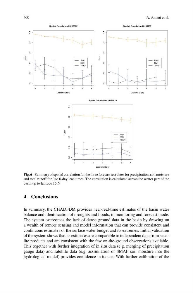
Fig. 6 Summary of spatial correlation for the three forecast test dates for precipitation, soil moisture
and total runoff for 0 to 6-day lead times. The correlation is calculated across the wetter part of the
basin up to latitude 15 N
4 Conclusions
In summary, the CHADFDM provides near-real-time estimates of the basin water
balance and identification of droughts and floods, in monitoring and forecast mode.
The system overcomes the lack of dense ground data in the basin by drawing on
a wealth of remote sensing and model information that can provide consistent and
continuous estimates of the surface water budget and its extremes. Initial validation
of the system shows that its estimates are comparable to independent data from satellite products and are consistent with the few on-the-ground observations available.
This together with further integration of in situ data (e.g. merging of precipitation
gauge data) and satellite data (e.g. assimilation of SMAP soil moisture into the
hydrological model) provides confidence in its use. With further calibration of the
A. Amani et al.
0
1
2
3
4
5
6
0.0
0.2
0.4
0.6
0.8
1.0
Spatial Correlation 20180502
Lead time (days)
Scorr
Prec
SM1
Totrun
0
1
2
3
4
5
6
0.0
0.2
0.4
0.6
0.8
1.0
Spatial Correlation 20180619
Lead time (days)
Scorr
Prec
SM1
Totrun
0
1
2
3
4
5
6
0.0
0.2
0.4
0.6
0.8
1.0
Spatial Correlation 20180707
Lead time (days)
Scorr
Prec
SM1
Totrun
Fig. 6 Summary of spatial correlation for the three forecast test dates for precipitation, soil moisture
and total runoff for 0 to 6-day lead times. The correlation is calculated across the wetter part of the
basin up to latitude 15 N
4 Conclusions
In summary, the CHADFDM provides near-real-time estimates of the basin water
balance and identification of droughts and floods, in monitoring and forecast mode.
The system overcomes the lack of dense ground data in the basin by drawing on
a wealth of remote sensing and model information that can provide consistent and
continuous estimates of the surface water budget and its extremes. Initial validation
of the system shows that its estimates are comparable to independent data from satellite products and are consistent with the few on-the-ground observations available.
This together with further integration of in situ data (e.g. merging of precipitation
gauge data) and satellite data (e.g. assimilation of SMAP soil moisture into the
hydrological model) provides confidence in its use. With further calibration of the